Quantcast
Channel: WORLD, COME TO MY HOME!
Viewing all 2426 articles
Browse latest View live

0976 GERMANY (Hesse) - A Bembel of Apfelwein, please, and Handkäse mit Musik!

$
0
0

Cider or cyder (named also "apple wine" in some regions) is a fermented alcoholic beverage made from fruit juice, traditionally apple juice, which varies in alcohol content from 1.2% ABV to 8.5% or more. Can be classified from dry to sweet, its appearance ranges from cloudy with sediment to completely clear, and its colour from light yellow through orange to brown,  the variations in clarity and colour being mostly due to filtering between pressing and fermentation. Is popular in the United Kingdom, that has the highest per capita consumption, as well as the largest producing companies in the world, but is also traditional in other European countries, such as Ireland, France (Brittany and Normandy), Spain (Asturias, Basque Country and Galicia), Poland or Germany (Rhineland-Palatinate and Hesse).

Read more »

0977 MOROCCO (Souss-Massa-Drâa) - Aït Larbi Kasbah on Dadès River valley

$
0
0

A kasbah is a type of fortress (citadel) in the Islamic cities, built by local leaders to live in it, and as defense when the city was under attack. On the valley of Dadès River, which rises in the High Atlas and then turns south crossing through the Dadès Gorge, then westward between the High Atlas and Anti-Atlas mountain ranges, are many such kasbahs. One of them is Aït Larbi, located near of Dadès Gorge, not far from Boumalne Dades, a town situated at the edge of a desert plateau. Built in the late 19th century, it consists actually of three kasbahs: Aït Hamid, Aït Amer, and Aït Juia Ali. The landscape that surrounds further increases their artistic value, by providing one of the most spectacular in the region settings.

Read more »

0706, 0978 UNITED STATES (California) - San Francisco cable car system

$
0
0

Posted on 28.06.2013, completed on 21.01.2014
It is said that there is no better way to experience the hills and views of San Francisco than aboard one of the city’s famous open-air cable cars, the world's last manually operated such system, and the only mobile National Monument in the United States. Of the 23 lines established between 1873 and 1890, have remained three and all three cross Nob Hill, which lies just north of downtown: the Powell-Hyde Line (the most scenic - it is in the postcard), the Powell-Mason Line, and the California Street Line.

As I said before, cable cars were introduced in San Francisco in 1873 by Andrew Smith Hallidie and the Clay Street Railroad company, and until the time of the great fire of 1906, they criss-crossed the entire city. After that, many of the cable car lines where re-opened using cheaper and more energy efficient electric streetcars, but however the cable cars were still much better at navigating the steep slopes of the downtown hills (in 1912 there were only eight lines). In the 1940's, the cable cars were almost destroyed again, making way for automobiles, but the Citizens Committee to Save the Cable Cars managed to defeat the corrupt politicians, who backed the auto industry. Since 1984, Muni (San Francisco Municipal Railway) has continued to upgrade the system.


This system is served today by two type of cable cars: single-ended (as those in the postcards) and double-ended. The first ones, which serve the Powell-Hyde and Powell-Mason lines, have an open-sided front section, with outward-facing seats flanking the gripman. The rear half of the car is enclosed, with seats facing inward and entrances at each end and the car has a small platform at the rear. These cars must be rotated to reverse direction at each end of the line, an operation performed on turntables. Most of these cars (28 in total) were built or rebuilt in the 1990s at Muni's Woods Carpentry Division.

According to Market Street Railway, a nonprofit preservation partner of the Muni, the cable car no. 9 (in the first postcard) "was built as open car No. 542 by Mahoney Bros., 1887. Converted to standard car 1923 and renumbered 509, rebuilt 1952, retired after accident in 1995. Currently in storage; could possibly be restored as open car." In the background of this postcard can be seen the Alcatraz Island, which housed probably the world's most famous prison. In the second postcard is the cable no. 11, operational, rebuilt in 1979-1980.

Read more »

0710, 0979-0984 UNITED STATES (Pennsylvania) - Life in Amish Country

$
0
0

Posted on 30.06.2013, completed on 23.01.2014
"Strolling along a rural road and admiring the flower, this Amish family is the sum total of all who went before. The Amish work with nature, not against it. They live in peace and brotherhood with with both man and nature - and in respecting both they have prospered." Even though I don't know this community than from some books and movies, I think that this description of the postcard is very appropriate. Known for simple living, plain dress, and reluctance to adopt the modern technology, the Amish (a group of traditionalist Christian church fellowships, actually a subgroup of the Mennonite churches) live in closed communities in 27 U.S. states and the Canadian province of Ontario, the largest population being in Ohio, Pennsylvania and Indiana.


The history of the Amish church began with a schism in Switzerland within a group of Swiss and Alsatian Anabaptists in 1693 led by Jakob Ammann. Those who followed Ammann became known as Amish. In the early 18th century, many Amish and Mennonites emigrated to Pennsylvania as a reaction to religious wars, poverty, and religious persecution on the Continent. The rules of the church, the Ordnung (order in German), must be observed by every member and cover most aspects of day-to-day living, including prohibitions or limitations on the use of power-line electricity, telephones, and automobiles, as well as regulations on clothing. Members who don't follow these rules are excommunicated. There is generally a heavy emphasis on church and family relationships, and a large families is considered a blessing from God. The more traditionally minded groups became known as the Old Order Amish. Most of them share a German or Swiss-German ancestry and speak Pennsylvania Dutch.


The Amish clothing is plain, and must not call attention. Hook-and-eye closures or straight pins are used as fasteners on dress clothing. Snaps are used on everyday clothes, and plain buttons for work shirts and trousers. Some groups tend to limit color to black and white, while others allow muted colors. Women wear calf-length plain-cut dresses in a solid color. Aprons are worn at home, usually in white (the unmarried) or purple or black (the married), and are always worn when attending church. Girls in some areas may wear colored bonnets until age nine, and begin wearing a cape for church and dress up occasions at about age eight. Men wear dark-colored trousers, with a dark vest or coat, and broad-rimmed straw hats in the warmer months. Married men and those over forty grow a beard. Mustaches are forbidden, because they are associated with European military officers and militarism in general.


Usually, the Amish don't educate their children past the eighth grade, believing that the knowledge offered up to that point is sufficient to prepare a child for their lifestyle. On the other hand, they believe that the pathway to heaven is paved with modesty, so a person must be separate from the world, forsake self interest and humbly submit to the authority of the church. The public education is considered a springboard toward individual advancement, independence, power, and distancing of the simple life. So the purpose of Amish education isn't to promote individuality and critical thinking, or to create artists, scientists, musicians or actors, but to prepare the children to remain Amish. In many communities, they have their own schools, which are typically one-room schoolhouses with teachers (young unmarried women) from their community.


According to the Amish, "progress" is not assumed to mean "something better", so they don't accept many of the modern conveniences - such as electricity generated by public power lines, TVs, computers and modern tractors - which are considered to be tempting elements from an "outside world", that could lead the Amish away from their close-knit community or weaken the family structure. However is acceptable to use some limited forms of electricity (such as battery power for the lights on their buggies), the phone (only a public one, not private) and some machinery (such as tractors without rubber tires). In this sense one of the icons of the Amish culture is the horse and buggy, though it has been a symbol of separation for only about the last century. It is the prominent mode of transportation, naturally limiting travel, and therefore, interaction with the non-Amish world. But while owning a car isn't permitted, to be a passenger is no compromise to their beliefs. Amish businessmen often have agreements with non-Amish persons to haul materials as needed, or hire a non-Amish employee who provides a vehicle.


Because children aren't counted in local congregation numbers, it's difficult to put an exact figure on the number of Amish, but was estimated that in 2008 were 221,000. In addition, they are among the fastest-growing populations in the world, with an average of seven children per family. There are Old Order communities in 27 U.S. states and the Canadian province of Ontario; Ohio has the largest population (55,000), followed by Pennsylvania (51,000) and Indiana (38,000). One of the largest Amish settlements are in Lancaster County (in south-central Pennsylvania), known since the 18th century as the Garden Spot of America. Even if only around 30,000 Amish people live in this county (6.37% of the total population), Lancaster is synonymous in American popular culture with Amish country, a place of peace, prosperity, and traditional values that has somehow survived unscathed the upheavals of the 20th century.


Amish homes are also plain and modest, though they tend to be sprawling to provide for extended family. Most are painted white, and old order homes are devoid of pictures on the walls and usually have no window curtains. Amish give their main house to the oldest son, when they retire, and, if there are children at home yet, there is a fairly large grandpa house built or if they don’t retire, the son will more than likely buy a farm or stay on the family land. Isn't uncommon for three and sometimes, four generations of a family to live under the same roof. The "family" provides the member with a status within the home and within the community. A person is more of a member of the family, rather than an individual. Each member has a job, a position, a responsibility, and a status.
 
Read more »

0985, 0986 SPAIN (Andalusia) - Alhambra, Generalife and Albayzín, Granada (UNESCO WHS)

$
0
0

Although the area was inhabited from at least the 8th century B.C., the actual founding of present day Granada, at the foot of the Sierra Nevada mountains, at the confluence of four rivers (the Beiro, the Darro, the Genil and the Monachil), took place in the 11th century, during a civil war that ended the Caliphate. In a short time this village was transformed into one of the most important cities of Al-Andalus, spreading across the Darro to reach the hill of the future Alhambra, and included the Albayzín neighborhood. With the Reconquista in full swing after the conquest of Cordoba in 1236, the Nasrids aligned themselves with Ferdinand III of Castile, officially becoming the Emirate of Granada in 1238. In 1492, the last Muslim ruler in Iberia, Emir Muhammad XII, surrendered complete control of the Emirate of Granada to Ferdinand II and Isabella I, Los Reyes Católicos (The Catholic Monarchs), after the last battle of the Granada War. Actually the fall of Granada completed the Reconquista, putting an end to the 800 year-long Islamic rule in the Iberian Peninsula.

Rising above the modern lower town, the Alhambra and the Albaycín, situated on two adjacent hills, form the medieval part of Granada, designated a UNESCO World Heritage Site in 1984 (with an extension in 1994). To the east of the Alhambra fortress and residence are the magnificent gardens of the Generalife, the former rural residence of the emirs. The residential district of the Albaycín is a rich repository of Moorish vernacular architecture, into which the traditional Andalusian architecture blends harmoniously.


The Alhambra was originally constructed as a small fortress in 889, and then ignored until was rebuilt in the mid 11th century by Mohammed ben Al-Ahmar, and later converted into a royal palace in 1333 by Yusuf I. Moorish poets described it as "a pearl set in emeralds," in allusion to the colour of its buildings and the woods around them. It is organized around two rectangular courts, the Patio de Los Arrayanes and the Patio de Los Lames, and includes a large number of rooms of a highly refined taste, with marble columns, stalactite cupolas, ornamental works in stucco, gaily coloured azulejos, precious wood inlayed and sculpted, and paintings on leather compete with the richness and the delicacy of the natural decor: the water, still and sparkling in immense basins, flows out into the basins of the fountains (the circular fountain of the Court of Lions), glides through narrow canals, and explodes into jets of water or falls in refreshing cascades. The walls are covered by delicate arabesques and about 10,000 inscriptions (verses from the Qur'an, poems, panegyrics of various kings, and aphorisms) which stand atop vibrant, multicoloured wainscotings of ceramic tiles (azulejos).

Read more »

0029, 0987 INDIA (Tamil Nadu) - Great Living Chola Temples - Brihadisvara Temple at Thanjavur (UNESCO WHS)

$
0
0

Posted on 06.11.2011, and completed on 24.01.2014
In both postcards is Brihadisvara temple, also known as Rajarajeswaram or Peruvudaiyar Kovil, located in Thanjavur (formerly Tanjore) in state of Tamil Nadu, in the southern part of India. Dedicated to Lord Shiva and considered as one of the greatest glories of India, this temple reflects the power of its creator, Raja Raja Chola I (985-1014 AD), the greatest of the Chola Monarchs, which has built it between the year 1003 and 1010. It was listed as one of the world heritage site by UNESCO in 1987, and in 2004 was joined other two temples built by kings of the Chola Empire in 11th and 12th centuries, the Brihadisvara Temple at Gangaikondacholisvaram and the Airavatesvara Temple at Darasuram, forming together the site Great Living Chola Temples, which testify to the brilliant achievements of the Chola in architecture, sculpture, painting and bronze casting.

The temple, one of the largest in India and one of India's most prized architectural sites, can be approached from the eastern side through two gateways (or Gopuras - one can be seen in the first postcard). The exterior is decorated with hundreds of painted sculptures and the interior has a massive statue of Nandi Bull (the mount of Lord Shiva), a shrine with octagonal dome known as Chandeshvara, a columned hall, a towered sanctuary and other small shrines. On the walls of the sanctuary are well carved figures of Shiva and other gods (lingams), but also frescoes portraying the mythological episodes of the journey of Sundarar and the Chera King to heaven, the battle scene of Tripurantaka (Lord Shiva) with Asuras (demons). In the frescoe from the second postcard is Chamunda, a fearsome aspect of Devi, the Hindu Divine Mother and one of the seven Matrikas (mother goddesses). The temple stands within a fort, whose walls (also in the first postcard) are later additions built in the 16th century.


In the Hindu religion the elephant represents Lord Ganesha, who became the Lord (Isha) of all existing beings (Gana) after winning a contest from his brother Kartikay. When given the task to race around the universe, Ganesha didn’t start the race as Kartikay did, but simply walked around Shiva and Parvati, his father and mother as the source of all existence. One of the most important Gods, Ganesha is worshipped by virtually every Hindu, whatever his other spiritual preferences. Many large Hindu temples have elephants outside their doors (donated to them to use daily or hire for use during important festivals) to give blessings to visitors (as can be seen in the first postcard). Each blessing costs a nominal fee which is split between the elephant trainer (mahout) and the temple. 

Read more »

0988 SPAIN (Andalusia) - The map of Andalusia

$
0
0

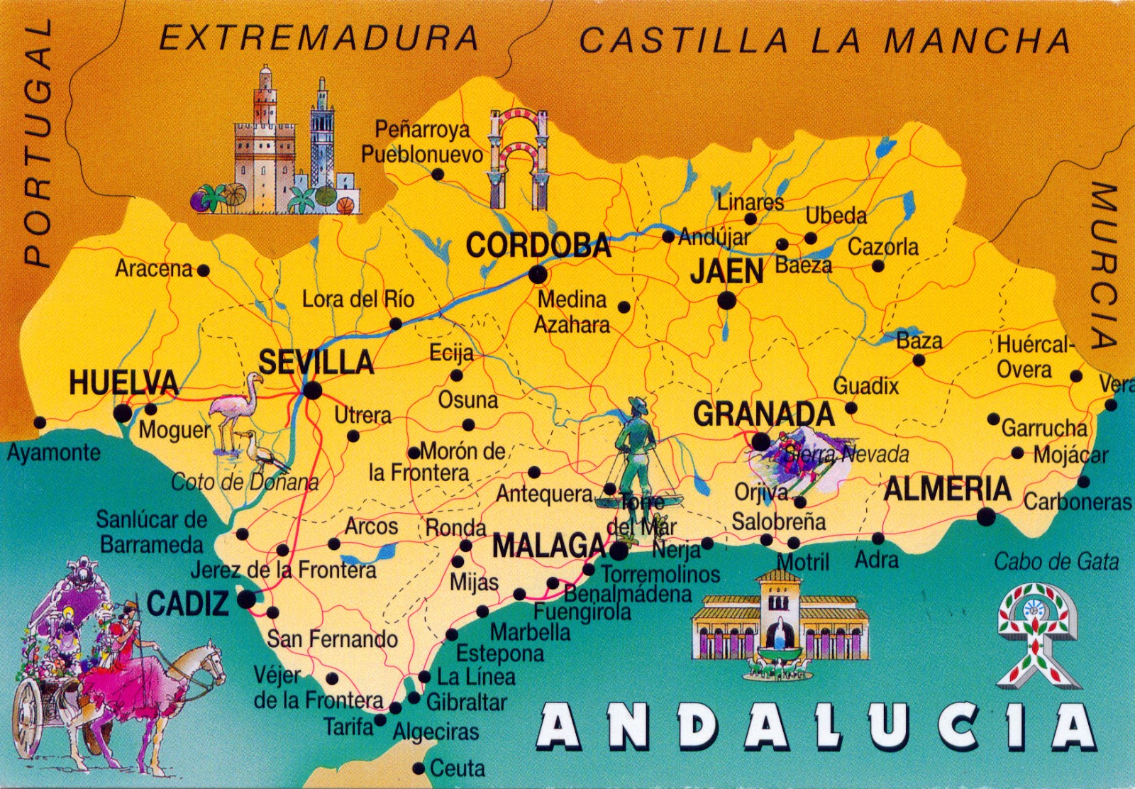
Even if Spain is a highly decentralized state, being composed, in terms of administrative, by 17 autonomous communities and 2 autonomous cities, is, in accordance with the constitution of 1978, a unitary state, not a federation. In other words, the Spanish nation is the common and indivisible homeland of all Spaniards, which is integrated by nationalities and regions to which the constitution recognizes and guarantees the right to self-government. The terms "nationalities", though never defined officially, are territories whose inhabitants have a strong historically constituted sense of identity. Andalusia, which occupies the south of the Iberian peninsula, is one of those nationalities, and its official motto clearly reflects its position relative to the unitary state: "Andalucía por sí, para España y la humanidad"  (Andalusia by herself, for Spain and for Humankind).

Read more »

0989 MOROCCO - Two women, two colours, the same hayek

$
0
0

The Qur'an instructs both Muslim men and women to be modest. According to the Encyclopedia of Islam and Muslim World, this modesty concerns to gaze, gait, garments, and genitalia. The consequence is the hijab (that literally means in Arabic “screen" or "curtain”), which not only refers to the physical body covering, but also embodies a metaphysical dimension, where al-hijab refers to "the veil which separates man or the world from God." As clothing, hijab is a veil that covers the head and chest of the Muslim women beyond the age of puberty in the presence of adult males outside of their immediate family. He may have a broader sense, refering to any head, face, or body covering worn by Muslim women as a symbol of modesty, privacy and morality. A traditional Muslim garment is the abaya, a simple, loose over-garment, essentially a robe-like dress, traditionally black, a large square of fabric draped from the shoulders or head, or a long caftan. The abaya covers the whole body except the face, feet, and hands. It can be worn with the niqāb, a face veil covering all but the eyes.

Read more »

0990-0995 UNITED STATES (New York) - The bridges in New York City

$
0
0
Brooklyn Bridge & Downtown Manhattan

New York City is home to over 2,000 bridges and tunnels, some of which were premieres or set records. For example the Holland Tunnel was the world's first vehicular tunnel when it opened in 1927, and the Brooklyn, Williamsburg, George Washington, and Verrazano-Narrows bridges were the world's longest suspension bridges when were opened in 1883, 1903, 1931, and 1964 respectively. The first bridge in New York, King's Bridge, was constructed in 1693, over Spuyten Duyvil Creek between Manhattan and the Bronx. Now the oldest crossing still standing is High Bridge, which connects Manhattan to the Bronx over the Harlem River. On the other hand, the George Washington, High Bridge, Hell Gate, Queensboro, Brooklyn, Manhattan, Macombs Dam, Carroll Street, University Heights and Washington bridges have all received landmark status.

Brooklyn Bridge and Lower Manhattan

New York features bridges of all lengths and types, carrying everything from cars, trucks and subway trains to pedestrians and bicycles. The George Washington Bridge, spanning the Hudson River between New York City and Fort Lee (New Jersey), is the world's busiest bridge in terms of vehicular traffic, but also, togheter with Verrazano Narrows Bridge and the Brooklyn Bridge, is considered among the most beautiful in the world. Others are more well known for their functional importance such as the Williamsburg Bridge, which has two heavy rail transit tracks, eight traffic lanes and a pedestrian sidewalk.

Brooklyn Bridge
 

The Brooklyn Bridge stretches 1.825m over the East River, connecting the New York City boroughs of Manhattan and Brooklyn, is one of the oldest suspension bridges in the United States, and also the first steel-wire suspension bridge constructed. Designed by German immigrant John Augustus Roebling, it was completed in 1883, and has become in a short time an icon of New York City. The architectural style is Neo-Gothic, with characteristic pointed arches above the passageways through the towers, built of limestone, granite blocks (quarried and shaped on Vinalhaven Island, Maine), and Rosendale cement.

Brooklyn Bridge and Lower Manhattan

Roebling designed a bridge and truss system that was six times as strong as he thought it needed to be. Because of this, the Brooklyn Bridge is still standing when many of the bridges built around the same time have vanished into history and been replaced. The paint scheme of the bridge is "Brooklyn Bridge Tan" and "Silver", although it has been argued that the original paint was "Rawlins Red". Since the 1980s, it has been floodlit at night to highlight its architectural features. A bronze plaque is attached to one of the bridge's anchorages, which was constructed on a piece of property occupied by a mansion, the Osgood House, at 1 Cherry Street in Manhattan. It served as the first Presidential Mansion, housing George Washington, his family, and household staff from April 23, 1789 to February 23, 1790, during the two-year period when New York City was the national capital.

Manhattan Bridge at twilight

The Manhattan Bridge is the last of the three suspension bridges built across the lower East River (following the Brooklyn and the Williamsburg bridges), connecting Lower Manhattan (at Canal Street) with Brooklyn (at Flatbush Avenue Extension). Designed by Leon Moisseiff, who later designed the Tacoma Narrows Bridge (that collapsed in 1940), it was opened on December 31, 1909. A year later, Carrère and Hastings drew up preliminary plans for an elaborate grand entry to the bridge on the Manhattan side (in Chinatown), as part of the "City Beautiful" movement. The arch and colonnade were completed in 1915, and the decoration includes pylons sculpted by Carl A. Heber and a frieze called "Buffalo Hunt" by Charles Rumsey. On the Brooklyn side, the bridge ends in the popular neighborhood DUMBO (Down Under the Manhattan Bridge Overpass).

Queensboro Bridge & Midtown Manhattan (aerial view)

The Queensboro Bridge (also known as the 59th Street Bridge) is a double cantilever bridge over the East River, which connects the neighborhood of Long Island City in the borough of Queens with the Upper East Side of Manhattan, passing over Roosevelt Island. The plans were finished in 1903 and construction soon began, but lasted until 1909 to be completed, due to delays from the collapse of an incomplete span during a windstorm and from labor unrest (including an attempt to dynamite one span). The bridge doesn't have suspended spans, so the cantilever arm from each side reaches to the midpoint of the span. Until it was surpassed by the Quebec Bridge in 1917, the span between Manhattan and Roosevelt Island was the longest cantilever span in North America. In December 2010, the bridge was renamed Ed Koch Queensboro Bridge in honor of the former mayor Ed Koch, a decision unpopular among Queens residents and business leaders.

Read more »

0996 FRANCE (Aquitaine) - Bordeaux, Port of the Moon (UNESCO WHS)

$
0
0

Bordeaux is a port city on the Garonne River, in southwestern France, known mainly as the world's wine industry capital. At first a Celtic settlement, it came under Roman rule around 60 BC, being sacked by the Vandals, then by the Visigoths and Franks, who have taken it in possession. It started to play a regional role on the fringes of the Frankish Duchy of Vasconia, being meant to keep in check the Basques and defend the mouth of the Garonne from the Vikings. Between 12th and 15th centuries it regained importance following the marriage of Duchess Eleanor of Aquitaine with Count Henri Plantagenet, the future King Henry II of England. The city flourished, even being for a while the capital of an independent state, but in the end was annexed by France. In the 16th century it became the center of the distribution of sugar and slaves from the West Indies, along with the traditional wine. The 18th century was its golden age, many downtown buildings being built in this period. In 1870, at the beginning of the Franco-Prussian War, the French government relocated to Bordeaux. This happened again during the WWI and again very briefly during the WWII, when it was also a submarine base from Axis powers.

Read more »

0997 INDIA - Mahatma Gandhi, Father of the Indian Nation

$
0
0

In 1869, when was born Mohandas Karamchand Gandhi, had passed 11 years since the British Crown had taken over the direct rule of British Raj (comprising at that time almost all present-day India, Pakistan, Bangladesh, and Myanmar), and in 1948, when he was assassinated by a Hindu nationalist, just had taken place the partition of the British Indian Empire, which had resulted in the creation of the sovereign states of the Dominion of Pakistan (later split into the Islamic Republic of Pakistan and the People's Republic of Bangladesh) and the Union of India (later Republic of India). As though he came into the world just to destroy the British Raj and to bring independence to India. Known in the West as Mahatma (Great Soul in Sanskrit), name given by Rabindranath Tagore, and in India as Bapu (endearment for "father" in Gujarati), he was not only the man who led India to independence, but also the one who inspired movements for civil rights and freedom across the world, his rules about nonviolent civil disobedience  being followed by other important leaders and activists, as Martin Luther King Jr., Nelson Mandela, Aung San Suu Kyi, Cesar Chavez, or Desmond Tutu.

Read more »

0998 GERMANY (Bavaria) - Freight locomotive 86 260 in 1968 at Plattling depot

$
0
0

The DRG Class 86 was a standard goods train tank locomotive with the Deutsche Reichsbahn-Gesellschaft (DRG) (German Imperial Railway Company), intended for duties on branch lines. They were of 2-8-2 wheel arrangement in the Whyte notation, or 1′D1′ h2 in the UIC classification, most often referred to as a Mikado, frequently shortened to Mike, but at times it was also referred as the McAdoo Mikado and, during WWII, the MacArthur. This wheel arrangement allows the locomotive's firebox to be placed behind instead of above the driving wheels, thereby allowing a larger firebox that could be both wide and deep. This supported a greater rate of combustion and thus a greater capacity for steam generation, allowing for more power at higher speeds.

Read more »

0999 INDONESIA (Java) - Being the owner of a cock makes him proud

$
0
0

The truth is that the cock from the postcard is a really beautiful one. At first I believe that is a fighting cock, especially that cockfighting is a very old tradition in Balinese Hinduism, but then I realized that can't be, because it has big comb and wattle, and at the fighting cocks these are removed, because they would be a disadvantage during a match. Moreover, the man is Javanese. Anyway, the rooster is an important animal for many ethnic groups from Indonesia, of different religions. I don't know much about birds, so I can't say precisely what breed is, probably Bekisar or Kedu.

Read more »
0891-0892, 0911-0912, 0943 & 1000 UNITED STATES (Arizona) - Grand Canyon National Park (UNESCO WHS)

$
0
0

Posted on 07.12.2013, 20.12.2013, 06.01.2014, and 31.01.2014
The park's central feature is the Grand Canyon, a gorge carved out by the Colorado River (nearly 1,500m deep, 445.8km long), which is often considered one of the Seven Natural Wonders of the World. Its horizontal strata retrace the geological history of the past 2 billion years, and there are also prehistoric traces of human adaptation to a particularly harsh environment. The primary public areas of the park are the North and South Rims of the Grand Canyon itself. The rest of the park is extremely rugged and remote, although many places are accessible by pack trail and backcountry roads. Only the Navajo Bridge near Page connects the rims by road in Arizona.


"The finest workers in stone are not copper or steel tools, but the gentle touches of air and water working at their leisure with a liberal allowance af time..." writted the poet Henry David Thoreau nearly 200 years ago. And the President Theodore Roosevelt said in 1903 after he visited visited the site: "The Grand Canyon fills me with awe. It is beyond comparison - beyond description; absolutely unparalleled throughout the wide world... Let this great wonder of nature remain as it now is. Do nothing to mar its grandeur, sublimity and loveliness. You cannot improve on it. But what you can do is to keep it for your children, your children's children, and all who come after you, as the one great sight which every American should see."


The floor of the valley is accessible by foot, muleback, or by boat or raft from upriver. Hiking down to the river and back up to the rim in one day is discouraged by park officials because of the distance, steep and rocky trails, change in elevation, and danger of heat exhaustion from the much higher temperatures at the bottom. The most used are the corridor trails, of which perhaps the best known is the Bright Angel, originally built by the Havasupai Native American tribe for access to the perennial water source of present day Garden Creek. In the center of the third postcard can be seen Desert View Watchtower, also known as the Indian Watchtower at Desert View, a 21m) high stone building located on the South Rim. The four-story structure, completed in 1932, was designed by architect Mary Colter.


In the fourth postcard is Havasu Falls, a waterfall located on Havasu Creek, within Havasupai tribal lands. It consists of one main chute that drops over a 27m to 30m vertical cliff into a large pool. Due to the high mineral content of the water, the configuration of the falls is ever-changing and sometimes breaks into two separate chutes of water. The falls are known for their natural pools, created by mineralization, although the configuration of the falls and the pools are damaged or destroyed repeatedly by large floods that wash through the area. High calcium carbonate concentration in the water creates the vivid blue-green color and forms the natural travertine dams that occur in various places near the falls.


Many of the canyon's landmarks were named by geologist Charles Dutton who published one of the earliest detailed geologic studies of the canyon in 1882. He believed that the canyon was such an important feature on the planet, that the names of its features should reflect all the world's cultures and thus he chose many names from mythologies from around the world. This explains the names of the three formations of the fifth postcard, respectively Krishna Temple, Vishnu Temple and Freya Castle. Other geologists named rock layers after surrounding landmarks, so the rock which forms the crystalline basement that underlie the Bass Limestone of the Unkar Group of the Grand Canyon Supergroup and the Tapeats Sandstone of the Tonto Group was named Vishnu Schist, after Vishnu Temple. And is only an example.


Where the North Rim is wild and remote, the South Rim is teaming with activities, sites, lodging and more. Most who visit the Grand Canyon come here and for good reason, because it’s much more accessible, many roads leading here from major cities like Las Vegas or Phoenix, while to the North Rim leads just one road. One of the popular spot on the South Rim for gazing into the canyon is Moran Point, named after the painter and etcher Peter Moran. The sixth postcard depicts "the afternoon sun beyond a snow covered pinyon pine near Moran Point along the South Rim highlights Angel's Gate and Deva Temple."

Read more »

1001 RUSSIA - Lenin

$
0
0

If Mahatma Gandhi was one of the most luminous personalities of the 20th century, Vladimir Ilyich Lenin (1870-1924) was one of the darkest. Born as Vladimir Ilyich Ulyanov to a middle-class family in Simbirsk (renamed Ulyanovsk after his death), Lenin was attracted by the revolutionary leftist politics following the execution of his brother in 1887. Expelled from Kazan State University for his radical attitude, he completed his law degree as an external student in 1891. In 1893 he moved to Saint Petersburg, where he began his career of professional revolutionary as cofounder of the League of Struggle for the Emancipation of the Working Class. Arrested and exiled to Siberia for three years, he married Nadezhda Krupskaya, and fled to Western Europe, where he emerged as a prominent figure in the international revolutionary movement and became the leader of the Bolshevik faction of the Russian Social Democratic Worker's Party.

Read more »

1002 SPAIN (Andalusia) - La Alcazaba in Málaga

$
0
0

Located on the Costa del Sol (Coast of the Sun) of the Mediterranean, at about 100 km east of the Strait of Gibraltar and about 130 km north of Africa, Málaga enjoys a subtropical-mediterranean climate and has a history of about three millennia. Founded by the Phoenicians, reached under the hegemony of Ancient Carthage, then was ruled by the Roman Republic and later the Roman Empire. After the fall of the empire, it was ruled first by the Visigoths and then by the Byzantine Empire, and in the 8th century was conquered by Moors, as most part of the Iberian Peninsula. In 1487 it again came under Christian rule in the Reconquista. The archaeological remains and monuments make the historic center of the city an "open museum", displaying its rich history.

Read more »

1003 NETHERLANDS - Tulip fields & cheese girl

$
0
0

As wrote Wilma, this is, obviously, a touristic postcard, following three clichés about Netherlands: the tulips, the cheese and the Dutch bonnet. But it fully attains its purpose, because the image is catchy, and the bright colors and the pleasant smile, added for diversity, on the house, successfully contribute to the overall impression. From the first glance, you say, dreamy or enthusiastic, "I want to see this country." Am I wrong?

Read more »

0092, 0171, 0534, 1004-1005 CAMBODIA (Siem Reap) - Angkor (UNESCO WHS)

$
0
0

Posted on 06.01.2012, 14.04.2012, 02.03.2013 and 16.02.2014
Subjected to the Indian influences, passed through filters Thai or Lao, for more than 1,000 years, the Khmer have created firstly kingdoms of Funan and Chenla, to achieve peak during the Khmer Empire (centuries 9th-15th), of which greatest material legacy is Angkor, the site of the capital city during the empire's zenith. The spiritual legacy is Theravada Buddhism, introduced to the area through monks from Sri Lanka in the 13th century, considered for centuries an esential element of the khmer's ethnic and cultural identity. If about the early days of the empire we don't know too much, after the 13th century Angkor was visited by many travelers, starting with chinese Zhou Daguan and continuing with Portuguese and Spanish missionaries. The Khmer already constructed the most important architectural masterpieces in the area known as Angkor, the largest preindustrial city in the world, with more than one million inhabitants. .Angkor, located to the north of the Great Lake (Tonlé Sap) and south of the Kulen Hills, near modern-day Siem Reap, is a UNESCO World Heritage Site from 1992.

The principal temple, Angkor Wat (in the first three postcards), was built between 1113 and 1150 by King Suryavarman II, as his personal temple mausoleum. It’s the world's largest religious building and it has become a symbol of Cambodia, appearing on its national flag. Very well preserved, it’s the only one to have remained a significant religious centre since its foundation - first Hindu, dedicated to the god Vishnu, then Buddhist. The most comprehensive presentation of the temple and the most easily accessible to a wide public seems to be that of The Monuments of the Angkor Group by Maurice Glaize, published in 1944 in Saigon. I will quote only a few short, but representative fragments, a "snack" if you like:


"Angkor may be visited in all seasons. However the most favourable period extends from November to March, during the first months of the dry season, when the temperature is particularly clement. […] It is preferable, particularly in the hot season, to leave early in the morning and to return before eleven o'clock, and not to revisit in the afternoon until three or four o'clock - the light at the end of the day being generally more favourable. The majority of the monuments - and in particular Angkor Wat - lose much in being viewed against the light. […] We would especially recommend the setting of the sun at Angkor Wat, where sometimes the spectacle will include the flight of the bats in the fading light, or from the top of Phnom Bakheng or Phnom Krom, or the terrace of the Srah Srang - or else from the beach of the baray, where the bathing is delightful. Finally, if you have the opportunity, do not miss, by the light of the full moon, the second level courtyard of Angkor Wat at the foot of the central tower, or the upper terrace of the Bayon."

"Constructed to the south of the capital (Angkor Thom), Angkor Wat is sited in the south-east corner of the ancient city of Angkor - Yasodharapura - built by Yasovarman I, centred on Phnom Bakheng and which stretched between the Siem Reap river to the east and the dike of the baray to the west. […] Isolated from the forest by its moats, Angkor Wat was, of all the monuments of the group, the best placed to escape the invasion of the jungle and hence ruin. Moreover, following the establishment of Buddhism of the small vehicle, it has always sheltered pagodas, as a place of pilgrimage for the Khmer, within its enclosure - though at one time partially masking the main façade these had to be re-sited in order not to detract from the overall perspective."


Another very interesting work that talks also about Angkor is Voyage dans les royaumes de Siam, de Cambodge, de Laos et autres parties centrales de l'Indo-Chine (Travels in the Central Parts of Indo-China, Cambodia and Laos During the Years 1858,1859, and 1860), by Henri Mouhot, published in 1863 in Paris. Mouhot is the one who popularized Angkor in the West, naming it "the work of the King of Angels."


In the fourth postcard are two Apsaras, females spirits of the clouds and waters in Hindu and Buddhist mythology (also known as Vidhya Dhari or Tep Apsar in Khmer, which means "nymph" or "celestial maiden"). Beautiful, youthful and elegant, often the wives of the Gandharvas (the court musicians of Indra), Apsaras are superb in the art of dancing, seducing equally gods and men. As caretakers of fallen heroes, they may be compared to the valkyries of Norse mythology, and as ethereal beings often depicted taking flight, to angels, but sometimes are also compared to the muses of ancient Greece. Probably due to the association with water, they are able to change their shape at will. Apsaras represent an important motif in the stone bas-reliefs of the Angkorian temples, but not all female images are considered to be apsaras, the ones who have static attitude being called devatas. Angkor Wat features both apsaras and devatas, but the devatas are the most numerous. Khmer classical dance, the indigenous ballet-like performance art, is frequently called "Apsara Dance" and reflects one of the origin myths in Cambodia, depicting the union of Mera, a celestial dancer, and Kambu, a wise man.


Built in the late 12th century or early 13th century as the official state temple of the Mahayana Buddhist King Jayavarman VII, the Bayon Temple (in the fifth postcard) stands at the centre of Jayavarman's capital, Angkor Thom, meaning the intersection of heaven and earth. Following Jayavarman's death, it was modified and augmented by later Hindu and Theravada Buddhist kings in accordance with their own religious preferences. Bayon is known for its huge stone faces of the bodhisattva Avalokiteshvara, with one facing outward and keeping watch at each compass point. The curious smiling image, thought by many to be a portrait of Jayavarman himself, has been dubbed by some the "Mona Lisa of Southeast Asia." There are 51 smaller towers surrounding Bayon, each with four faces of its own. The temple is known also for two impressive sets of bas-reliefs, which present an unusual combination of mythological, historical, and mundane scenes. I have to appeal again to the book The Monuments of the Angkor Group, comprehensive and accessible:

Read more »

1006 BAHRAIN - Pearling, Testimony of an Island Economy (UNESCO WHS)

$
0
0

Located on the island with the same name, Muharraq (literary "burned down" in Arabic) has long been a centre of religiosity, and even the capital of Bahrain until 1923, when it was replaced by Manama. Its origins goes back to the time of Dilmun (Telmun) 5,000 years ago, but the city became important during the era of Tylos, when Bahrain came under domination of the Seleucid Empire. By the 5th century AD, it had become a major centre of Nestorian Christianity. Taken by the Portuguese (1521) and then by the Persians (1602), Al-Muharraq passed to the control of the Āl Khalīfah dynasty in 1783. It developed as a trade centre, its harbour being the chief headquarters for the formerly important Bahraini pearl-diving industry, virtually extinct since the 1930s.

Read more »

1007-1008 INDONESIA (Java) - The Olden Days Indonesia

$
0
0

"The Olden Days Indonesia" is a series comprising wonderful reproductions of postcards issued at the beginning of the 20th century. The couple shown in the first of these was immortalized, undoubtedly, with a special occasion. On the original, published by J. art shop Sigrist from Jogja (today Yogyakarta), is written "Javaansche Bruid en Bruidegom - Temanten laki en prampoean di poelo Djawa" (i.e. "Bride and groom in Java"). Actually the photo don't show an ordinary bridal couple - even if, as far as I know, the two were not identified (nor the photographer) - but a patrician one, and this thing is proven by the clothes, a typical kraton (royal palace) wedding dress of Yogyakarta.

Both of them wears a gold bracelet on arm, with a dragon head. Ornament worn on the chest is a gold necklace with a three objects, called calendar. The ear jewelry, sumping, are shaped like wings and leather images are painted with golden color. The hat worn by the groom, kuluk, is made of glass. Batik patterns are used quite unique as well . The bride is dressed in dodotan (Javanese traditional clothes of batik) and bun bokornya as motif headdress, with a special frilly headdress cassowary feathers, decorated with flowers and jebehan bight.


In the second postcard is a wayang orang performance in the same city, in 1920. Wayang (which means shadow) is a Javanese word for particular kinds of theatre. About wayang kulit, or shadow puppets, I wrote here. Wayang wong (in Javanese), or wayang orang (in Indonesian - literally means "human wayang") is a type of unmasked dance theatrical performance, with themes taken from episode of Ramayana or Mahabharata. Performances are stylised, reflecting Javanese court culture. Garrett Kam, a Hawaii-based teacher and performer of Javanese dance, wrote in a article in 1982: "Wayang wong dance drama in the central Javanese Kraton (royal court) of Yogyakarta represents the epitome of Javanese aesthetic unity. It is total theatre involving dance, drama, music, visual arts, language, and literature. A highly cultured sense of formality permeates every aspect of its presentation". Originally, it was performed only as an aristocratic entertainment in palaces of Yogyakarta and Surakarta, the first court dance drama, Gondorwedoyo (Scent of the Heart), being presented under the personal direction of Hamengku Buwana I in the 18th century. In the course of time, it spread to become a popular and folk form as well.

Read more »
Viewing all 2426 articles
Browse latest View live