Quantcast
Channel: WORLD, COME TO MY HOME!
Viewing all 2426 articles
Browse latest View live

0118, 1227 CROATIA - The map and the flag of the country

$
0
0
 

Posted on 07.02.2012 and 17.09.2014
When Croatia has separated from Yugoslavia and it has declared independence, I thought that its territory's shape (as the jaws of a crocodile - isn't at all a political allusion) will be very difficult to defend. And probably so it's, but the war of four years that followed proved that this mission isn't impossible to accomplish. The upper "jaw" is Slavonia (closely linked with the Croatia itself in the last thousand years), and the lower "jaw" is Dalmatia. In fact the present border between Croatia and Bosnia Herzegovina (located between "jaws") is, with certain approximation, the boundary which separated, for centuries, Austrian Empire and Ottoman Empire.


The area known as Croatia today was inhabited throughout the prehistoric period, fossils of Neanderthals being unearthed in northern Croatia, with the most famous and the best presented site in Krapina. The Iron Age left traces of the early IllyrianHallstatt culture and the CelticLa Tène culture. Much later, the region was settled by Liburnians and Illyrians, the first Greek colonies were established on the islands of Korčula, Hvar and Vis. In 9 AD the territory became part of the Roman Empire. Emperor Diocletian built a large palace in Split when he retired in AD 305. The period ends with Avar and Croat invasions in the first half of the 7th century and destruction of almost all Roman towns. Tomislav became the first king by 925, elevating Croatia to the status of a kingdom, which retained its sovereignty for nearly two centuries. Croatia entered a personal union with Hungary in 1102, and in 1527, faced with Ottoman conquest, the Croatian Parliament electedFerdinand I of the House of Habsburg to the throne.

Read more »

0409, 1228 CHINA (Beijing) - Imperial Palaces of the Ming and Qing Dynasties in Beijing and Shenyang (UNESCO WHS)

$
0
0

Posted on 10.12.2012 and 17.09.2014
Built between 1406 and 1420 by a million of workers, Zijin Cheng (literally Purple Forbidden City), served for almost 500 years as the home of emperors - 14 of the Ming Dynasty and 10 of the Qing Dynasty - as well as the ceremonial and political center of Chinese government.  It's located in the middle of Beijing and covers 720,000 m2 (a rectangle with 961m from north to south and 753m from east to west), on which there is 980 surviving buildings with 8,886 bays of rooms (9,999 including antechambers). It is surrounded by a 7.9m high wall and a 6m deep by 52m wide moat. The walls are 8.62m wide at the base, tapering to 6.66m at the top. At the four corners of the wall sit towers with intricate roofs boasting 72 ridges, reproducing the Pavilion of Prince Teng and the Yellow Crane Pavilion as they appeared in Song Dynasty paintings. These towers are the most visible parts of the palace to commoners outside the walls. In the postcards is (I believe) the northwest corner tower.


The legend say that Emperor Yongle of the Ming Dynasty, ordered the chief project commander to build four fine corner towers, each with 9 girders, 18 posts and 72 ridges. The chief project commander gathered all the carpenters together and gave them three months to fulfill that complicated and delicate mission. A carpenter met an old man selling grasshoppers and bought a grasshopper cage for relief. To his surprise, the cage had 9 girders, 18 posts and 72 ridges so the problem was solved. The Forbidden City is part of the site Imperial Palaces of the Ming and Qing Dynasties in Beijing and Shenyang, which was declared a World Heritage Site in 1987, and is listed by UNESCO as the largest collection of preserved ancient wooden structures in the world.

Read more »

1229 AUSTRALIA - Koala

$
0
0

According to biologist Stephen Jackson: "If you were to take a straw poll of the animal most closely associated with Australia, it's a fair bet that the koala would come out marginally in front of the kangaroo".In 1997 e.g. about 75 percent of European and Japanese visitors to Australia placed the koala at the top of their list of animals to see. Factors that contribute to the koala's popularity in nowadays include its childlike body proportions and teddy bear-like face, even if early European settlers in Australia considered the koala to be a prowling sloth-like animal with a "fierce and menacing look".

Read more »

1229 CAYMAN ISLANDS - Here are Cayman Islands

$
0
0

Located in the western Caribbean Sea, south of Cuba and northwest of Jamaica, the Cayman Islands are a British Overseas Territory which comprises three islands: Grand Cayman, Cayman Brac and Little Cayman. Until the 17th century the islands weren't inhabited than by pirates, refugees and deserters. England took formal control of the Cayman Islands, along with Jamaica, as a result of the Treaty of Madrid of 1670. Following several unsuccessful attempts at settlement, a permanent English-speaking population in the islands dates from the 1730s. After 1734 were brought many black slaves from Africa, even if the slavery was less common on the Cayman Islands than in other parts of the Caribbean. The islands continued to be governed as part of the Colony of Jamaica until 1962, when they became a separate Crown colony.

Read more »

1230 JORDAN (Amman) - King Abdullah I Mosque

$
0
0

Completed in 1989 as a memorial by the late King Hussein (r. 1952-1999) to his grandfather, Abdullah I bin al-Hussein, Emir of Transjordan between 1921 and 1946, and king of Jordan since 1946 until 1951, this unmistakable blue-domed mosque can house up to 7000 worshippers inside, and another 3000 in the courtyard area. This is the only mosque in Amman that openly welcomes non-Muslim visitors. The cavernous, octagonal prayer hall doesn’t have any pillars, yet it’s capped by a massive dome, 35m in diameter. The inscriptions quote verses from the Quran.

Read more »

1152-1154, 1234-1235 ARUBA - The map of the country

$
0
0


Posted on 20.07.2014 and 20.09.2014
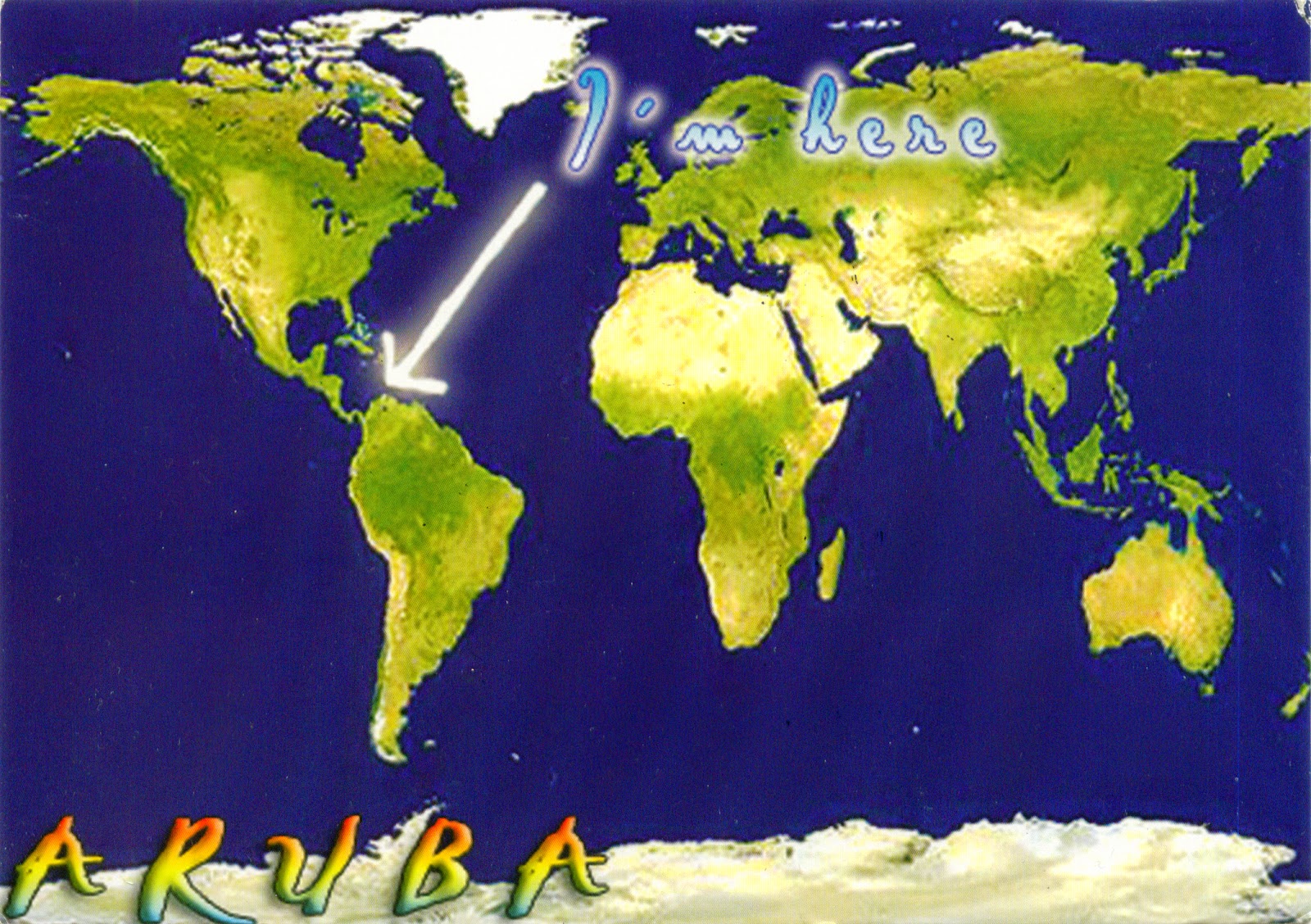
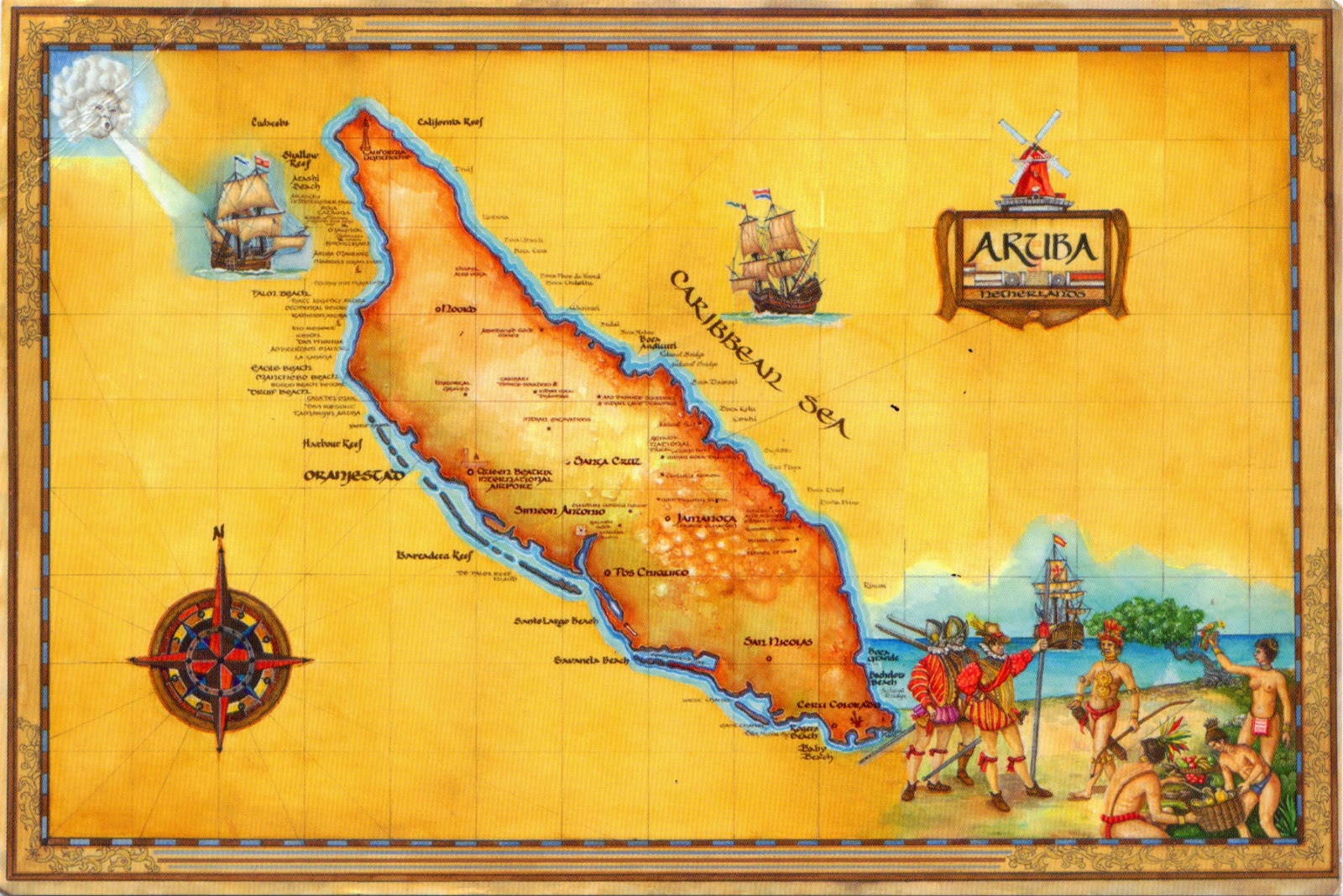
Located about 1,600km west of the Lesser Antilles in the southern Caribbean Sea and 27km north of the coast of Venezuela, Aruba forms, together with Bonaire and Curaçao, a group referred to as the ABC islands. On the other hand, Aruba and the other Dutch islands in the Caribbean are often called the Netherlands Antilles or the Dutch Caribbean. It is one of the four constituent countries that form the Kingdom of the Netherlands, along with the Netherlands (which comprises not only the European land, but also Bonaire, Sint Eustatius, and Saba), Curaçao and Sint Maarten.


A generally flat, it lies outside the hurricane belt, and, unlike much of the Caribbean region, has a dry climate and an arid, cactus-strewn landscape. It has white sandy beaches on the western and southern coasts of the island, relatively sheltered from fierce ocean currents. The population is estimated to be 80% mixed Black/White/Caribbean Amerindian and 20% other ethnicities, and the Arawak heritage is stronger on Aruba than on most Caribbean islands. The official languages are Dutch and - since 2003 - Papiamento, a language derived from African and Portuguese languages with some influences from American Indian languages, English, Dutch and Spanish.


Aruba's first inhabitants were Caquetíos Amerinds from the Arawak tribe, who migrated there from Venezuela, and Europeans first learned of it following the explorations by Amerigo Vespucci and Alonso de Ojeda. Because it had low rainfall, it was not considered profitable for the plantation system and the economics of the slave trade. Since 1636, it has been under Dutch administration, which left the Arawaks to farm and graze livestock, and used the island as a source of meat for other Dutch possessions in the Caribbean.


Aruba has one of the highest standards of living in the Caribbean region, its economy being dominated by tourism, gold mining, phosphate mining, aloe export, and petroleum refining. About three quarters of its gross national product is earned through tourism or related activities. The capital and largest city of Aruba is Oranjestad (Orange Town), located on the southern coast near the western end of the island. The town was built around Fort Zoutman shortly after it was built in 1796, and was named in 1820 after the first King Willem van Oranje-Nassau (William of Orange-Nassau) - the first heir to the Dutch House of Orange.


Read more »

1236 VIETNAM (Northwest) - The pig market in Sa Pa

$
0
0

Located in Lào Cai Province in northwest Vietnam, close to the border with China, at 380 km north-west of Hanoi, Sa Pa is a quiet mountain town and home to a great diversity of ethnic minority peoples. Besides the Kinh (Viet) people (15%) there are mainly 5 ethnic groups in Sapa: Hmong 52%, Dao 25%, Tay 5%, Giay 2% and a small number of Xa Pho. Approximately 7,000 live in Sapa, the other 36,000 being scattered in small communes throughout the district with the same name. The Kinh never originally colonised this highest of Việt Nam’s valleys, which lies in the shadow of Phan-Xi-Pǎng (Fansipan - 3143m), the highest peak in the country. Most of the ethnic minority people work their land on sloping terraces, and the unique climate in Sapa, with sub-tropical summers, temperate winters and 160 days of mist annually, has a major influence on their lives.

Read more »

1237 POLAND (Mazovia) - The Presidential Palace in Warsaw

$
0
0

Located on the Krakowskie Przedmieście, one of the best known and most prestigious streets of Poland's capital, not far from Historic Centre of Warsaw (an UNESCO WHS since 1980) the Presidential Palace is the elegant classicist latest version of a building that has stood on this site since 1643. For its first 175 years, the palace was the private property of several aristocratic families, in 1791 it hosted the authors and advocates of the Constitution, and in 1818 it began its ongoing career as a governmental structure, when it became the seat of the Viceroy of the Polish (Congress) Kingdom under Russian occupation. Following Poland's resurrection after WWI, the building was taken over by the authorities and became the seat of the Council of Ministers. During WWII, it served the country's German occupiers as a Deutsches Haus and survived miraculously the 1944 Warsaw Uprising. After the war, it resumed its function as seat of the Polish Council of Ministers, and in 1955 the Warsaw Treaty was signed here. Since 1994 it has been the official seat of the President of the Republic of Poland.

Read more »

1238 MALDIVES - Vivanta by Taj Coral Reef resort on North Male Atoll

$
0
0

Located in the Indian OceanArabian Sea area, Maldives consists of a double chain of twenty-six atolls, oriented north-south, that lie between Minicoy Island and the Chagos Archipelago. Maldives is the lowest country in the world, with maximum and average natural ground levels of only 2.4m and 1.5m above sea level, respectively. More than 80 per cent of the country's land is composed of coral islands which rise less than one metre above sea level. One of these atolls is Malé, which consists of two separate atolls: North Malé Atoll and South Malé Atoll. North Malé Atoll (Male'atholhu Uthuruburi) is of irregular shape, is 58 km long, and contains about 50 islands (including the capital Malé). There are also sandbanks, coral patches, innumerable farus and submerged shoals (called "haa" in Dhivehi). The general depths of the interior are between 46 and 64m. The bottom is sandy. There are numerous passages on all sides. Seen from space it is considered one of the most beautiful atolls on the planet. Practically all uninhabited islands of this Atoll became tourist resorts during the two final decades of the 20th century.

Read more »

1239 UNITED STATES (New Mexico) - White Sands National Monument (UNESCO WHS - Tentative List)

$
0
0

Located in  the mountain-ringed Tularosa Basin, at about 25 km southwest of Alamogordo, at an elevation of 1,291m, White Sands National Monument comprises the southern part of a 710-km² field of white sand dunes composed of gypsum crystals (the largest gypsum dune field in the world). Gypsum is rarely found in the form of sand because it is water-soluble, and normally rain would dissolve the gypsum and carry it to the sea. The Tularosa Basin is enclosed, so that rain that dissolves gypsum from the surrounding San Andres and Sacramento Mountains is trapped within the basin. Thus water either sinks into the ground or forms shallow pools which subsequently dry out and leave gypsum in a crystalline form, called selenite, on the surface.

Read more »

1240 TUNISIA (Kairouan) - Kairouan (UNESCO WHS)

$
0
0

Located in the centre of Tunisia, in a plain at an almost equal distance from the sea and the mountain, Kairouan (Al Qairawān) was founded around 670, as an Arab military post for the conquest of the West. The site had housed a Byzantine garrison before the Arab conquest, far from the sea - safe from the continued attacks of the Berbers, who had fiercely resisted the Arab invasion. In the period of Caliph Mu'awiya (r. 661-680), it became an important centre for Islamic and Quranic learning, and thus attracting a large number of Muslims, next only to Mecca and Medina. In 745, Kharijite Berbers captured it, but Ibrahim ibn al-Aghlab recaptured it at the end of the 8th century. In 800 Caliph Harun ar-Rashid confirmed Ibrahim as Emir and hereditary  ruler of Ifriqiya. He founded the Aghlabid dynasty, who built the great mosque and established in it a university, whose role can be compared to that of the University of Paris in the Middle Ages. The year 909 saw the establishment of the ShiiteFatimid dynasty, which neglected the city. When the Zirids declared their independence from Cairo and their conversion to Sunni Islam in 1045, the Fatimid Caliph Ma'ad al-Mustansir Billah sent punishment hordes, which destroyed Kairouan in 1057. Despite the transfer of the political capital to Tunis in the 12th century, Kairouan remained the Maghreb's principal holy city.

Read more »

0636-0644, 1241-1242 ROMANIA (Suceava) - Churches of Moldavia (UNESCO WHS)

$
0
0


Posted on 11.05.2013 and 23.09.2014
This series of postcards, named Patrimonio and depicting Churches of Moldavia (listed by UNESCO as a World Heritage Site in 1993 and 2010), has for me and my collection a particular importance, and the reasons are very well founded. It hasn't yet appeared on the market, so I'm the first who had the joy of receiving it, through the courtesy of Marius Vasiliu, author of the photographs, and of Terra Design, the printing house in Gura Humorului which issued them. I must say that the collaboration between Marius and Terra Design is already old, and this isn't the first very special achievement of this tandem, in previous years being edited numerous postcards (normal or folded), related primarily to the Bukovina's traditions, and its cultural and artistic heritage, but also to the present of this historical region and its inhabitants. You can find some of them on the official website of the printing house, here.

The Churches of Moldavia are eight Orthodox churches built between 1487 and 1583, in a time when the increasing threat of the Ottoman Empire and then pressures exerted by the Protestant Reformation were an ongoing concern for the princes of Moldavia, boyars and the Orthodox Church. The architecture of these churches has been developed over the 15th century, in a cultural ambience marked by the influence of Byzantium and Serbia. In terms of the plan were adopted original solutions with a development trend in length, some Gothic elements stressing the originality of this architecture that blends the Byzantine and Gothic traditions. The silhouette of the buildings, strongly individualized by the broken line of the roofs, contributes decisively to define specific aspect of this architecture. But the most distinctive element of these churchs are the external paintings, which cover all the facades, masterpieces of mural painting, with a consummate chromatism and a remarkable elegance of the figures. In addition, not fewer of the topics chosen for the paintings, mostly taken from the Bible and the Holy Scriptures, are encountered only here.

• PROBOTA (Church of St. Nicholas and the Catholicon of the Probota Monastery)


Erected in 1530, Probota Monastery served as the royal necropolis (1522-1677), here being the tombs of the VoivodePetru Rareş (illegitimate son of Ştefan cel Mare, and founder of the monastery) and Ştefan Rareş (son of Petru Rareş), Lady Elena Rareş and other members of the princely family of Moldavia. Plundered in 1622 by thieves, was later restored by Voivode Vasile Lupu, and in 1677 was dedicated to the Church of the Holy Sepulchre in Jerusalem. Greeks monks who were installed there totally neglected the conservation of the ensemble. After secularization of monastic estates (1863), the buildings have been degraded further, the cells and princely houses being consumed by fire in the early 20th century. It was restored in several stages, 1934-1937, 1986, 1992-2001, and in 1993 the monastery was re-established, as a nuns community. Recent restoration revealed, under a layer of newer painting, the original painting of great artistic value. The church's distinctive note is given by the vault painted, which remind of the vault of the Sistine Chapel in the Vatican.

ARBORE (Church of the Beheading of St. John the Baptist)


Erected in 1503, was the court chapel of Luca Arbore, pârcălab (burgrave) of Suceava, one of the great boyars of Ştefan cel Mare, beheaded in 1523 from the command of Ştefăniţă Vodă. Being founded by a boyar, it has no towers, and was designed in a simple form, stunning  through its great stylization, but in its construction can be observed some architectural innovation and a great equilibrium of proportions. Mural painting, executed in 1541 by Dragoş Coman from Iaşi, is characterized by the exceptional durability of the blue pigment. Was preserved the tomb's ark of the monastery's founder, considered the most valuable funeral mark in Gothic style in Bukovina. Instead, the boyar's court completely crumbled over time, being destroyed by fire. The interior painting was severely damaged, but however can be seen clearly enough, and the exterior one, including scenes populated by many characters in constant motion, has a rare artistic value.

MOLDOVIŢA (The Church of the Annunciation of the Moldoviţa Monastery)


Built by Petru Rareş in 1532, Moldoviţa Monastery is surrounded by walls and towers for defence, as a fortress, in that time being situated at the northern border of Moldavia. Between 1610 and 1612 was built clişarniţa (the abbot's house), where were kept the treasures of the church, but also operated a school of copyists and miniaturists. Moldoviţa's frescoes were painted by Toma of Suceava in 1537. The predominantly yellow-and-blue paintings on its exterior represent recurring themes in Christian Orthodox art: a procession of saints leads up to the Virgin enthroned with the Child in her lap, the Tree of Jesse, the Siege of Constantinople, which commemorates the intervention of the Virgin in saving the city of Constantinople from Persian attack in A.D. 626. The Last Judgment covers the entire surface of the west wall. Sister Maika, who has been living in the monastery for more than 50 years, says that it is "the holy scriptures in color". Moldoviţa and Humor are the last churches built with an open porch, a hidden place above the burial-vault, and with Gothic-style windows and doors.

HUMOR (Church of the Assumption of the Virgin of the former Humor Monastery)


Erected in 1530 by Petru Rareş and his chancellor Teodor Bubuiog, Humor Monastery was one of the first of Moldavia's painted monasteries to be frescoed and, along with Voroneţ, is the best preserved. The dominant colour of the frescoes, painted in 1535 by Toma of Suceava, is a reddish brown. The subjects of the frescoes, common to the painted monasteries of Bukovina, include the Siege of Constantinople and the Last Judgment. In 1641, Vasile Lupu surrounded the monastery with stone walls and built a massive tower with ground floor and three floors. In 1653 the Cossacks looted and torched it, and in 18th century the church was converted into a parish church. The frescoes was restored in the years 1971-1972, as also the roof and the tower. In 1991 the monastic settlement was reactivated as a monastery for nuns.

PĂTRĂUŢI (Church of the Holy Rood of Pătrăuţi)


Buit in 1487, it's the first definite foundation of Ştefan cel Mare, and her reputation comes from the narthex wall painting with a topic rare: cavalcade Holy Cross. The monastery was abandoned repeatedly, being plundered by the Cossacks, Tartars and then Poles (in 1684). In the early 18th century it was repaired, and in 1711 was reestablished convent of nuns, but only for a few decades. It was closed in 1783 and the church was converted into a parish church, in this situation being even today. In 2003 have started restoration works, being brought to light some fragments of interior fresco of inestimable artistic and historical value. The church has exterior painting only on the west wall, representing the Last Judgement. It was discovered in the 1980s and is considered the oldest exterior religious painting in Moldavia. In 1725 was built a wooden belfry, which exists today. In the churchyard there is a stone round table, also assigned by tradition of Ştefan cel Mare.

VORONEŢ (Church of St George of the former Voroneţ Monastery)


This monastery was built in less than four months in 1488 by Ștefan cel Mare, to commemorate the defeat of the Ottomans at Podul Înalt (the High Bridge) in 1475, a battle described as "the greatest ever secured by the Cross against Islam," with casualties, according to Venetian and Polish records, reaching beyond 40,000 on the Ottoman side. For this Ştefan was awarded the title "Athleta Christi" (Champion of Christ) by Pope Sixtus IV. Often known as the "Sistine Chapel of the East", the frescoes at Voroneţ, made in 1547, feature an intense shade of blue known in Romania as "Voroneţ blue". Another characteristic note is painters' rich creative imagination, who introduced folk elements in the composition. Inside the church hold the attention the pews and the armchair from the 16th century (including a royal armchair, a true masterpiece of wood sculpture), the tomb of Bishop Grigore Roşca, in the porch, and the tomb of Daniil the Hermit, in the narthex. Monastic life was interrupted in 1785 and resumed in 1991 as a nuns community.

SUCEVIŢA (Church of the Resurrection Suceviţa Monastery)


Built in 1585 by Ieremia Movilă, Gheorghe Movilă and Simion Movilă and painted in exterior around 1601, Suceviţa was not only a fortified monastery, but as well a princely residence, surrounded by high (6m), and wide (3m) walls, and guarded at the corners by four towers. The thick walls today shelter a museum that presents an outstanding collection of historical and art objects. The tombs of Ieremia and Simion Movilă - rich portraits embroidered in silver thread - together with ecclesiastical silverware, books and illuminated manuscripts, offer an eloquent testimony to Suceviţa's importance first as a manuscript workshop, then as a printing center. Is the only church of the eight which was inscribed on the UNESCO list in 2010. Like to the others, exterior and interior mural paintings is of great artistic value, being a comprehensive biblical narrative of the Old and New Testaments.

SUCEAVA (Church of St. George of the Saint John the New Monastery)


The present church of the monastery was started in 1514 by the son of Ştefan cel Mare, Bogdan Chiorul, and finished by Ştefăniţă Vodă in 1522. It was intended to be the new headquarters of the Metropolitan Church of Moldavia and was painted both inside and outside between 1532-1534, during the reign of Petru Rareş, the iconography being characteristic to the monuments builded ​​during this period. In 1589 they were brought relics of St. John the New of the old metropolitan. The iconostasis dates from 1796 and belongs to Moldavian Baroque style, remarking from the impressive sizes, ornamental and chromatic richness. The frescoes are the work of Moldavian craftsmen from the time of Petru Rareş.

Read more »

1243 PORTUGAL (Lisbon) - A shoeshiner in Lisbon in 1987

$
0
0

In Western civilization, the occupation of shoeshiner was probably one of the most ephemeral, appearing in the early 20th century and disappearing in most European countries before its conclusion. However, shining shoes still is an important source of income for many children and families throughout the world. Some shoeshiners offer extra services, such as shoe repairs and general tailoring. Although this occupation is generally regarded with condescension, quite a lot well-known and high profile people started their working life as shoeshiners, including singers and presidents, such as James Brown, The Godfather of Soul, the human rights activist Malcolm X, or the brazilian president Luiz Inácio Lula da Silva.

Read more »

1244 BRUNEI - Sultan Omar Ali Saifuddin Mosque

$
0
0

Built on an artificial lagoon on the banks of the river Brunei, Sultan Omar Ali Saifuddin Mosque dominates not only so-called village in the water, Kampong Ayer, but even the skyline of  Bandar Seri Begawan, the capital of the sultanat. The mosque initially seems more attraction than place of worship. However, this could not be farthest from the truth, and the grandiose mosque was in fact designed solely for prayer to Allah. Completed in 1958 and named after Omar Ali Saifuddien III, the 28th Sultan of Brunei who also initiated its construction, the mosque serves as a symbol of the Islamic faith in Brunei, the official religion of the state. Formally, the freedom of religion is guaranteed, but more recently the Sultan has announced strict penalties for those who leave Islam.

Read more »

1245 ROMANIA (Sălaj) - Baking moşoroane at House-Museum of Ligia Bodea

$
0
0

Although in nowadys it has a population only slightly more than 800 inhabitants, the village Iaz in the commune Plopiş (Sălaj County) is known throughout the country due to the House-Museum of Ligia Bodea, which hosts an ethnographic collection with hundreds of folk costumes, thousands of ceramic pots, glass icons and dowry chests, and other traditional objects. The museum has a short history, but very special. In 2003, at the death of his grandmother, Ligia Bodea, who was then only 12 years old, persuaded his parents to not demolish the old house, built around 1880. She also kept in good condition the objects with which had grown, as ordained them her grandmother, and began to gather other from the village. Amazed by the girl's tenacity, her parents were also involved and thus the house became a museum, extending then on the yard, where, in an gazebo, are exposed various agricultural machines. Ligia dreams of a ecomuzeu and, until be able to fulfill this dream, participates in exhibitions and cultural projects, teaches children to paint icons on glass, and talks to the elders, because the memories of the old world must not disappear along with them.

Read more »

1246 AFGHANISTAN - Paghman Valley

$
0
0

Located very near for the capital Kabul, west of the city, the fertile Paghman Valley is one of the most visited places, mostly for the Paghman Gardens, arranged by King Amanullah after his 1927-1928 tour of Europe, India and Iran. Paghman, a small village at the bottom of the Hindu Kush, became a holiday retreat with villas and chalets as well as the summer capital. The region seriously suffered during the soviet war in Afghanistan, but also after becoming a Mujaheddin battleground at the close of the 20th century.

Read more »

1247 UNITED STATES (North Carolina) - The map and the flag of State of North Carolina

$
0
0

Located on the Atlantic coast, between South Carolina, Georgia, Tennessee, and Virginia, and known as the Tar Heel State and the Old North State, North Carolina has a wide range of elevations, from sea level to 2,037m at Mount Mitchell (the highest point in the Eastern US), consisting of three main geographic sections: the Atlantic Coastal Plain, the Piedmont region, and the Appalachian Mountains and foothills. Its capital is Raleigh, founded in 1792 specifically for this purpose, and its largest city is Charlotte. Most of the state falls in the humid subtropical climate zone. In the past five decades, North Carolina's economy has undergone a transition from heavy reliance upon tobacco, textiles, and furniture-making to a more diversified economy with engineering, energy, biotechnology, and finance sectors.

Read more »

1248 GUERNSEY - Saint Peter Port Harbour at down

$
0
0
 

Saint Peter Port is the capital of Guernsey, one of the two british bailiwick located in the English Channel, possession of the Crown and part of the Channel Islands. It is a small town, with a population of about 16,500, consisting mostly of steep narrow streets and steps on the overlooking slopes. A trading post existed here since before Roman times, but its pre-Christian name hasn't survived into the modern era. On the seaward side it faces Herm to the east, across the Little Roussel, and Sark and Brecqhou even further east across the Big Roussel between them and Herm. The Bréhon Tower sits in the Little Roussel between St Peter Port and Herm. Saint Peter Port Harbour, a natural anchorage used by the Romans, is now Guernsey's main port for passengers.

Read more »

1249 PHILIPPINES (Luzon) - Kumintang

$
0
0

The kumintang is the name given to several distinct styles, techniques and forms in music and dance, probably originating in the areas used by early Spanish chronicles to denote a province centering around what is known as Batangas, on the southwestern part of Luzon. Early 19th-century travelers' accounts often mention the kumintang as a Tagalog"chant national", describing them as dance-songs performed by pairs of men and women, with texts concerning love and courtship. All accounts mention a glass of coconut wine passed from hand to hand by the dancers as they sing. Jean Baptiste Mallat describes it as a pantomimic dance where the man runs around and gestures to a woman, and finally pretends illness to get the woman's full attention. In the 20th century, Francisca Reyes-Aquino dubbed as kumintang the circular hand and wrist movement also known as the kunday. Among present-day afficinados of musical and dance events called awitan and pandangguhan in and around the city of Batangas, kumintang also refers to a guitar-plucking style, considered the most melodious and beautiful of all guitar styles accompanying the old kinanluran style of pandangguhan dance songs.

Read more »

1250 MEXICO (Querétaro) - Historic Monuments Zone of Querétaro (UNESCO WHS)

$
0
0

Santiago de Querétaro, the capital and largest city of the state of Querétaro, located in central Mexico, at 213km northwest of Mexico City, was founded on 25 July 1531, when during a battle between the Spanish and the natives of the area, an eclipse occurred during which Saint James on a white horse carrying a pink cross supposedly appeared, causing the natives of the areas to surrender. The old colonial town of Querétaro is unusual in having retained the geometric street plan of the Spanish conquerors side by side with the twisting alleys of the Indian quarters. The Otomi, the Tarasco, the Chichimeca and the Spanish lived together peacefully in the town, which is notable for the many ornate civil and religious Baroque monuments from its golden age in the 17th and 18th centuries.

Read more »
Viewing all 2426 articles
Browse latest View live