Quantcast
Channel: WORLD, COME TO MY HOME!
Viewing all 2426 articles
Browse latest View live

1315 PAKISTAN (Punjab) - Taxila (UNESCO WHS)

$
0
0

Now, Taxila (in Sanskrit Takshashila, literally meaning City of Cut Stone or Rock of Taksha) is a small town situated about 32km north-west of  Islamabad, but the ancient settlement was a noted centre of learning at least several centuries BC, and continued to attract students from around the old world until its destruction in the 5th century by the Huns. Generally, a student entered Takshashila at the age of sixteen. The Vedas, the ancient and the most revered Hindu scriptures, and the Eighteen Silpas or Arts, which included skills such as archery, hunting, and elephant lore, were taught, in addition to its law school, medical school, and school of military science. Situated at the pivotal junction of India, western Asia and Central Asia, Taxila also illustrates the different stages in the development of a city on the Indus that was alternately influenced by Persia, Greece and Central Asia. It is a vast serial site, that includes a Mesolithic cave and the archaeological remains of four early settlement sites, Buddhist monasteries, and a Muslim mosque and madrassa.

Read more »

1316 UNITED NATIONS - Ban Ki-moon, the eighth Secretary-General of the UN

$
0
0

The Secretary-General of the United Nations (UNSG) is the head of the UN Secretariat, and acts as the de facto spokesperson and leader of the organization. He is appointed by the General Assembly upon the recommendation of the Security Council, and serves for five-year terms that can be renewed indefinitely, although none so far has held office for more than two terms. The selection is subject to the veto of any of the five permanent Members of the Security Council (China, France, Russia, the United Kingdom, and the United States). The current UNSG is Ban Ki-moon, elected in 2006, and re-elected in 2010. He was named the world's 32nd most powerful person by Forbes Magazine's List of The World's Most Powerful People in 2013, the highest among Koreans.

Read more »

1317 IRAQ - The Dominican Clock Church in Mosul

$
0
0

With a rich ancient history, Mosul was an important trade center which linked Persia and the Mediterranean, so it was allways a cosmopolitan city. Christianity was present among the indigenous Assyrian people as early as the 2nd century, and later the city became a center for the Nestorian Christianity (it contains the tombs of several Old Testament prophets such as Jonah). After the annexation to the Rashidun Caliphate, the Islam became the dominant religion, but the city maintained, more than 1300 years, until Islamic State of Iraq and Syria (ISIS) took over it in 2014, a multicultural and multi-religious mosaic, despite the institutional ethnic persecution by various political powers.

Read more »

1318 KENYA - Maasai morans

$
0
0

The Maasai are a Nilotic ethnic group of semi-nomadic people inhabiting southern Kenya (840,000) and northern Tanzania (430,000), in the African Great Lakes region. According to their own oral history, they originated from the lower Nile valley north of Lake Turkana and began migrating south around the 15th century. As with the Bantu, the Maasai and other Nilotes in Eastern Africa have adopted many customs and practices from the Cushitic groups, including the age set system of social organization, circumcision, and vocabulary terms. They are herdsmen, and had a fearsome reputation as warriors and cattle-rustlers. The raiders used spears and shields, but were most feared for throwing clubs (orinka) which could be accurately thrown from up to 100m. In modern time they have resisted the urging of the Tanzanian and Kenyan governments to adopt a more sedentary lifestyle.

Read more »

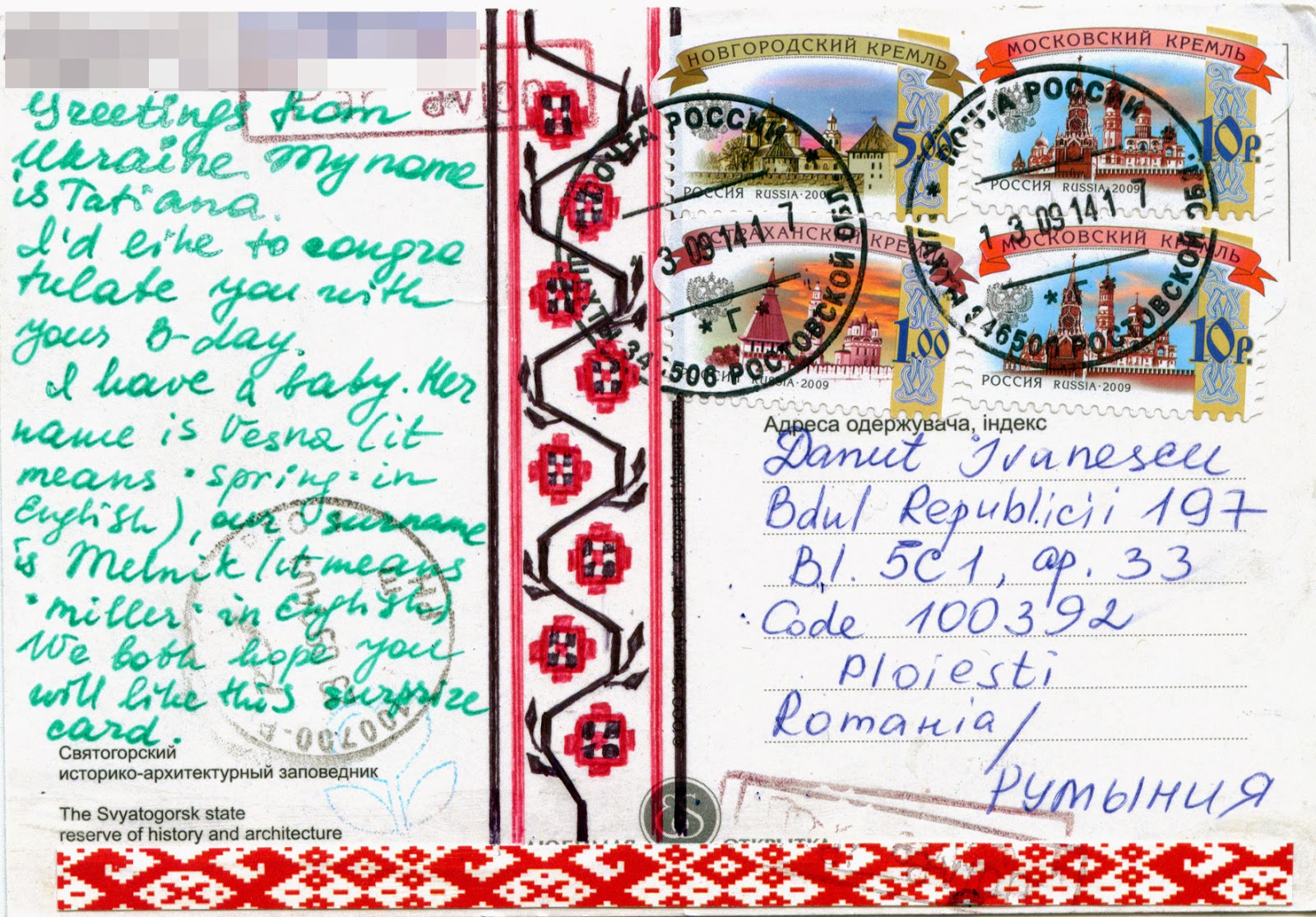
1319 UKRAINE (Donetsk Oblast) - Sviatohirsk Lavra

$
0
0

Named also the Holy Mountains Lavra, due to the surrounding mountains, Sviatohirsk Lavra is a historic Orthodox Christian monastery (a lavra) located on the right bank of the Seversky Donets River. The first monks settled in the area in the 14th century, but the first written mention of the monastery was in 1526, and in 1624 it was officially recognized as the Sviatohirsk Uspensky Monastery. During times of the Crimean Khanate it was invaded a couple of times, being restored in 1787, and in 1844. The lavra's main Dormition Cathedral was designed by Alexey Gornostaev, who included a traditional Byzantine tower. Before WWI It was inhabited by approximately 600 monks, in 1922 it was rebuilt and converted into a residence, and during the 1930s it was destroyed by the Soviets. After the fall of the Soviet Union the monastery was restored again.

Read more »

1320 VIETNAM - Hồ Chí Minh

$
0
0

Hồ Chí Minh led the Vietnamese nationalist movement for more than three decades, fighting first against the Japanese, afterwards against the French colonial power and then against the US-backed South Vietnam. He was a key figure in the foundation of the Democratic Republic of Vietnam (DRV) in 1945, becoming also its prime minister (1945-1955) and its president (1945-1969). Today, he has in Vietnam an almost god-like status, still being called Uncle Ho. In 1987, UNESCO officially recommended to Member States that they "join in the commemoration of the centenary of the birth of President Ho Chi Minh by organizing various events as a tribute to his memory", considering "the important and many-sided contribution of President Ho Chi Minh in the fields of culture, education and the arts" and that Ho Chi Minh "devoted his whole life to the national liberation of the Vietnamese people, contributing to the common struggle of peoples for peace, national independence, democracy and social progress". In his honor, after the Communist conquest of the South in 1975, Saigon was renamed Ho Chi Minh City.

Read more »

1321 GUYANA - Kaieteur Falls

$
0
0

Located on the Potaro River, in Kaieteur National Park, Kaieteur Falls were discovered in1870 by the British geologist Charles Barrington Brown. They have 226m high from its plunge over a sandstone and conglomerate cliff to the first break, and are among the most powerful waterfalls in the world, with an average flow rate of 663 cubic metres per second. In other words, this single drop waterfall is about four times higher than the Niagara Falls, and about twice the height of the Victoria Falls. In terms of the human heritage of this area, it was said to still be inhabited by native Amerindians. In fact, Kaieteur Falls was said to be named after an Amerindian chief by the name of Kai who gave his life by canoeing over the falls. Apparently he did this in order to protect his tribe from a rival Carib tribe by means of divine intervention (i.e. I guess the Great Spirit would intervene if Chief Kai sacrificed himself). The word "teur" meant falls in the native Amerindian language so technically it would be redundant to include the word "Falls" in Kaieteur.

Read more »

1322, 1323 NETHERLANDS (North Holland) - Zuiderkerk and Westerkerk in Amsterdam

$
0
0

Built between 1603 and 1611 in AmsterdamRenaissance style, as a pseudo-basilica in Gothic style, after a design by Hendrick de Keyser (buried in the church in 1621), the Zuiderkerk (Southern church) was the city's first church built specifically for Protestant services. It was used for church service until 1929, since 1988 serving as a municipal information centre. The distinctive church tower, which dominates the surrounding area (it has around 75m high including the wooden spire), wasn't completed until 1614 and contains a carillon of bells built by the brothers Hemony, installed in 1656 along with four bells which are rang monthly. Three of Rembrandt's children, and also Ferdinand Bol, one of Rembrandt's most famous pupils, were buried in the Zuiderkerk, which is very near to Rembrandt's house in the Jodenbreestraat. French Impressionist painter Claude Monet painted the church during a visit to the Netherlands. The composition is centred on the church spire, with the Groenburgwal canal leading up to it in the foreground. The painting is now in the Philadelphia Museum of Art.


Westerkerk (Western Church) was the city's third church built specifically for Protestant services (after Zuiderkerk and Noorderkerk), and today it remains the largest church in the Netherlands that was built for Protestants. Erected between 1620 and 1631 by the same Hendrick de Keyser, it has the highest church tower in Amsterdam, at 85m. The spire, called the Westertoren (Western tower) has in top the Imperial Crown of Austria of Maximilian I. 14 of the 50 church bells were made by François Hemony in 1658. Here was buried Rembrandt, who at the end of his life lived nearby, at Rozengracht 184. When he died in 1669, the painter was so poor, that he was buried in an unmarked church grave, with several other people, where human remains were buried only for 20 years, to make place for other poor people. That is why the exact place of Rembrandt’s grave remains unknown. His lover Hendrickje Stoffels is also buried here, as is his son Titus van Rijn. The Westerkerk is located also close to the Achterhuis (now Anne Frank House) where the girl, her family and others hid from Nazi persecution for two years during WWII. The Westerkerk is mentioned frequently in her diary - its clock tower could be seen from the attic of the Achterhuis and Anne Frank described the chiming of the clock as a source of comfort. A memorial statue of Frank is located outside the church.

Read more »

1324 NEPAL - Manaslu, Mountain of the Spirit

$
0
0

Manaslu, which means "Mountain of the Spirit", also known as Kutang, or Pung-Gyen (The Bracelet), the eighth highest mountain in the world (8,156m), is located in the Mansiri Himal, in the northern Himalayan range, in the west-central part of Nepal. The mountain's long ridges and valley glaciers offer feasible approaches from all directions, and culminate in a peak that towers steeply above its surrounding landscape, and is a dominant feature when viewed from afar. It was first climbed on May 9, 1956 by Toshio Imanishi and Gyalzen Norbu, members of a Japanese expedition. It is said that "just as the British consider Everest their mountain, Manaslu has always been a Japanese mountain". Until May 2008, the mountain has been climbed 297 times with 53 fatalities.

Read more »

1325 CUBA - Havana

$
0
0

Havana extends mostly westward and southward from the bay with the same name, which is entered through a narrow inlet and which divides into three main harbours: Marimelena, Guanabacoa and Atarés. The sluggish  Almendares River traverses the city from south to north, entering the Straits of Florida a few km west of the bay. Founded by the conquistador Diego Velázquez de Cuéllar in 1514 or 1515, it was originally a trading port and suffered regular attacks by by buccaneers, pirates, and French corsairs, but subsequently, due to its strategic location, it served as a springboard for the Spanish conquest of the continent becoming a stopping point for the treasure laden Spanish Galleons on the crossing between the New World and Spain. King Philip II of Spain granted Havana the title of City in 1592, and walls as well as forts were built to protect it.

Read more »

1326 SINGAPORE - Traditional Chinese street opera players

$
0
0

Wayang (a Malay word meaning "a theatrical performance employing puppets or human dancers") commonly refers to Chinese street opera in Singapore, though it is also used in reference to other forms of opera such as wayang kulit. In Mandarin, Chinese street opera is known as jiexi (street show). This traditional Chinese dramatic form, which incorporates a wide range of art forms like song, dance, mime, acrobatics and martial arts, was brought to Singapore by immigrants from China during the 19th century as part of their religious rites. It became in short time the most accessible form of entertainment for this community, and its popularity rose to such a level, that the large crowds at these performances worried the authorities. It continued to be performed at indoor venues and in the streets through the Japanese Occupation, but after that, as a result of the post-war developments, of the replacement of the dialects with Mandarin among the Chinese, and of the westernisation of the population, it ceased to be a form of mass entertainment, even if it is considered an icon of Chinese heritage and culture.

Read more »

1267, 1327 ITALY (Sicily) - Arab-Norman Palermo and the cathedral churches of Cefalù and Monreale (UNESCO Tentative List)

$
0
0

Posted on 03.10.2014 (1267) - The Cathedral-Basilica of Cefalù
Located on the northern coast of Sicily, Cefalù deserves noted mainly for its Cathedral, begun in 1131, in a style of Norman architecture, which would be more accurately called Sicilian Romanesque. According to tradition, the building was erected after a vow made to the Holy Saviour by the King of Sicily, Roger II, after he escaped from a storm to land on the city's beach. The Cathedral was consecrated in 1267. The exterior is well preserved, and is largely decorated with interlacing pointed arches. On each side of the façade is a massive tower of four storeys. The interior of the cathedral was restored in 1559, though the pointed arches of the nave, borne by ancient granite columns, are still visible; and the only mosaics preserved are those of the apse and the last bay of the choir; they are remarkably fine specimens of the Byzantine art of the period (1148) and, though restored in 1859-1862, have suffered much less than those at Palermo and Monreale from the process. The figure of the Christ Pantocrator gracing the apse is especially noteworthy.


Posted on 08.11.2014 (1327) - The cloister of the abbey of Monreale
Located 15km south of Palermo, on the slope of Monte Caputo, overlooking the very fertile valley called "La Conca d'oro" (the Golden Shell), Monreale was for a long time a mere village, and started its expansion when the Norman Kings of Sicily chose the area as their hunting resort. Under King William II the large monastery of Benedictines coming from Cava de' Tirreni, with its church, was founded. The Cathedral of Monreale, one of the greatest extant examples of Norman architecture in the world, was begun in 1174 by William II, and in 1182 the church was elevated to the rank of a metropolitan cathedral. Enlightened, tolerant and appreciative of many aspects of North African and middle-eastern culture and art, the king employed the very best Arabic and Byzantine, as well as Normans craftsmen to work on the cathedral. The result is a fabulous and fascinating fusion of architectural styles, artistic traditions and religious symbolism.

Read more »

0658, 1328 MEXICO (Veracruz) - El Tajin, Pre-Hispanic City (UNESCO WHS)

$
0
0

Posted on 25.05.2013 and completed on 08.11.2014
In 1785, an official stumbled upon by chance the Pyramid of the Niches, in the highlands of the municipality of Papantla, in the low mountains that lead from the Sierra Madre Oriental to the Gulf coast near the Tecolutla River. It is unclear who built the city, but the site was known to the local Totonac, whose ancestors may also have built it, as El Tajín, which was said to mean "of thunder or lightning bolt". Related to this is their belief that twelve old thunderstorm deities, known as Tajín, still inhabit the ruins. Anyway, between 600 and 1200 C.E. it was a prosperous city, one of the largest and most important of the Classic era of Mesoamerica, that controlled much of what is now modern Veracruz state, advantaged  by its strategic position along the old trade routes.


Considered to be crucial to the understanding of artistic and socio-economic development in the period between the Teotihuacan and Mexico-Tenochtitlan empires, and its architecture, characterized by elaborate carved reliefs on the columns and frieze, being unique in Mesoamerica, was designated a World Heritage Site by UNESCO in 1992, under the name El Tajin, Pre-Hispanic City. The settlement is divided into three areas, each constructed around a number of open spaces (plazas). The focus of the site is Pyramid of the Niches, which rises at 20m in 6 steps to a temple at the top, and has a wide staircase rising up its eastern side. Each storey has rows of square niches with overhanging cornices, 365 in total, one for each day of the solar year. The staircase is bordered by a step-and-fret motif; probably representing lightning.

Read more »

1329 AUSTRALIA (Christmas Island) - The annual red crab mass migration

$
0
0

Located at 500km south of Indonesia, and at 1,560km from the town of Exmouth, the closest point of the Australian mainland, Christmas Island is quite isolated, so had a high level of endemism among its flora and fauna. Unfortunately two species of native rats have become extinct, the endemic Christmas Island Shrew has not been seen since the mid-1980s, while the Christmas Island Pipistrelle (a small bat) is critically endangered and possibly also extinct. Now the land crabs and sea birds are the most noticeable fauna on the island. Twenty terrestrial and intertidal species of crab have been described here, of which thirteen are regarded as true land crabs, being only dependent on the ocean for larval development.

Read more »

0093, 0223, 0774, 1330 UNITED KINGDOM (England) - Stonehenge, Avebury and Associated Sites - Stonehenge (UNESCO WHS)

$
0
0

Posted on 08.01.2012, 26.05.2012, 30.07.2013 and 09.11.2014
I don't know if Stonehenge is the most important megalithic construction which survived the history, but certainly is the best known and most intensively researched. Located in the county of Wiltshire, at about 13km north of Salisbury, in the middle of the most dense complex of Neolithic and Bronze Age monuments in England, including several hundred burial mounds, Stonehenge assembly consists of four concentric circles made of standing stones set within earthworks. The outer circle (33m in diameter) is constructed of 30 sarsen blocks, arranged vertically, above which were placed as lintels some other blocks, circular arc-shaped. Inside is another circle of eggplant stone blocks. They surround a horseshoe-shaped arrangement, built also of eggplant stone, within which is a sandstone slab mecacee called the Altar Stone.


The whole building is surrounded by a circular ditch measuring 104m in diameter. Inside stands a sandbank which contains 56 tombs, known as the Aubrey holes (named after the discoverer). The embankment and the ditch are intersected by a processional path 23m wide and almost 3km long, Stonehenge Avenue, which connects Stonehenge with the River Avon, and the small henge on its bank, discovered in 2008, at West Amesbury. Near the entrance to the Avenue is Slaughter Stone (a fallen sarsen that once stood upright with one or two other stones across the entrance causeway), and on the other side is the Heelstone, a single huge unshaped sarsen boulder. The main axis of the stones is aligned upon the solstitial axis. At midsummer, the sun rises over the horizon to the north-east, close to the Heel Stone. At midwinter, the sun sets in the south-west, in the gap between the two tallest trilithons, one of which has now fallen.


With regard to construction's purpose, opinions are divided, the most important theories circulated claiming that Stonehenge have served as a burial ground, as a place of healing, as part of a ritual landscape or have a celestial observatory function. Even I'm not historian, may have my own opinion, isn't it? Personally I believe that the people who have built it (between 3100 and 1600 BC) just don't thinking like us, ie they not separate the sides of existence as we do, but they viewed things globally. Surrounding universe didn't have for them a sacred dimension and a profran one, but life, death, nature, cosmos, divinity was closely entwined, forming a inseparable whole. As a result I don't think there was a space where they worshiped gods, another in which they buried the dead, another in which they made astronomical observations and so on, but there was only one site (like Stonehenge) which served all these types of activities. Anyway, many aspects of Stonehenge remain subject to debate.


Throughout the twentieth century, Stonehenge began to be revived as a place of religious significance, this time by adherents of Neopagan and New Age beliefs, particularly the Neo-druids. The historian Ronald Hutton would later remark that "it was a great, and potentially uncomfortable, irony that modern Druids had arrived at Stonehenge just as archaeologists were evicting the ancient Druids from it." The first such Neo-druidic group to make use of the megalithic monument was the Ancient Order of Druids, who performed a mass initiation ceremony there in August 1905, in which they admitted 259 new members into their organisation. Between 1972 and 1984, Stonehenge was the site of the Stonehenge Free Festival. After the Battle of the Beanfield in 1985, this use of the site was stopped for several years and ritual use of Stonehenge is now heavily restricted.

About the stamps
On the first three postcard
All three stamps are part of the definitive series issued in 2011, about which I wrote here.

On the fourth postcard 
The first two stamps, depicting a tulipe and a crocus, belong to the set Blumen,about which I wrote here.


The last stamp was issued on September 1st, 2014, to commemorate a great literary work by Antoine de Saint-Exupéry - The Little Prince, published in 1943. It is both the most-read and most-translated book in the French language, and was voted the best book of the 20th century in France.

References
Stonehenge - Official website
Stonehenge, Avebury and Associated Sites - UNESCO official website
Stonehenge - Wikipedia
Stonehenge - english-heritage.org.uk

Sender 1, 2: Jeni & George Dragoman
Sent from London (England / United Kingdom), on 07.12.2011
Photo 1: Skyscan Balloon
Photo 2: James O. Davies 
Sender 3: Maura / fairymin (postcrossing)
Sent from Amesbury (England / United Kingdom), on 25.07.2013
Sender 4: Postcrossing meeting
Sent from Bielefeld (North-Rhine Westphalia / Germany), on 27.10.2014

1331 FRANCE (Provence-Alpes-Côte d'Azur) - Château d'If

$
0
0

The Château d'If is a fortress located on the island of If, the smallest island in the Frioul archipelago situated in the Mediterranean Sea about a mile offshore in the Bay of Marseille. It was built in 1524-1531 on the orders of King François I as a defence against attacks from the sea, and was instantly controversial. Marseille had been annexed to France in 1481, but the city retained in theory the right to provide her own defence. The new Château was to many people an unwelcome reminder of royal authority. Although it successfully repelled an attack on the port by Charles V of Spain in 1536, the cannons gradually proved inadequate to reach invading ships, so it became a prison in the mid-16th century. Subsequent inhabitants over the next 200 years included 3,500 Huguenots and a Monsieur de Niozelles who was given six years for failing to take his hat off in the presence of Louis XIV. Others were imprisoned without trial, for minor misdemeanours. The island became famous in the 19th century when Alexandre Dumas used it as a setting for The Count of Monte Cristo.

Read more »

1125, 1272, 1332 UNITED STATES (Utah) - The map and the flag of State of Utah

$
0
0

Posted on 04.07.2014, 08.10.2014, and 13.11.2014
Bordered by Colorado, Wyoming, Idaho, Arizona and Nevada (and touching a corner of New Mexico), Utah, one of the Four Corners states, is well known as the most religiously homogeneous state in the Union (its nickname is Beehive State), approximately 62% of Utahns being members of The Church of Jesus Christ of Latter-day Saints or LDS (Mormons), which greatly influences the state's culture and daily life. The world headquarters of The Church of Jesus Christ of Latter-day Saints (LDS Church) is located in the state capital, Salt Lake City, founded in 1847 in proximity to the Great Salt Lake. It is a geographically diverse state, located at the convergence of three distinct geological regions: the Rocky Mountains, the Great Basin, and the Colorado Plateau. Utah is known for its natural diversity and is home to features ranging from arid deserts with sand dunes to thriving pine forests in mountain valleys.


Thousands of years before the arrival of European explorers, the Anasazi/Ancestral Pueblo and the Fremont tribes lived in what is now Utah. Around the 18th century, the Navajo settled in the region, and then other Uto-Aztecan tribes, including the Goshute, the Paiute, the Shoshone, and the Ute people (who gave the name of the state). Spaniards explored the region in the 16th century, but weren't interested in colonizing. In 1821 it became part of Mexico (Alta California), and in 1824 Jim Bridger became the first white person to sight the Great Salt Lake. In 1847 Brigham Young and the first band of Mormon pioneers came to the Salt Lake Valley, and over the next 22 years, more than 70,000 pioneers crossed the plains and settled in Utah.


The Mormons wanted to establish a State of Deseret, but many of the members of the U.S. government opposed their polygamous practices. Between May 1857 and July 1858 held an armed confrontation between Mormon settlers and the armed forces of the US government (the Utah War), and beginning in 1865 Utah's Black Hawk War developed into the deadliest conflict in the territory's history. In the 1890 Manifesto, the LDS Church banned polygamy, so when Utah applied for statehood again, it was accepted, it becoming the 45th state admitted to the Union on January 4, 1896.

Read more »

1333 CANADA (Ontario) / UNITED STATES (New York) - Niagara Falls

$
0
0

Located on the Niagara River, which drains Lake Erie into Lake Ontario, on the border between Canada and the United States, between the twin cities of Niagara Falls, Ontario, and Niagara Falls, New York, Niagara Falls is in fact an assembly of three waterfalls: the Horseshoe Falls, the American Falls and the Bridal Veil Falls. The Horseshoe Falls (furthest on the postcard) lie mostly on the Canadian side and the American Falls (closest on the postcard) entirely on the American side, separated by Goat Island. The smaller Bridal Veil Falls are also located on the American side, separated from the other waterfalls by Luna Island. The boundary line was drawn through Horseshoe Falls in 1819, but it has long been in dispute due to natural erosion and construction. The combined falls form the highest flow rate of any waterfall in the world, with a vertical drop of more than 50m.

Read more »

1334, 1335 GERMANY (Berlin) - The Berlin Wall

$
0
0

The Berlin Wall (German: Berliner Mauer) was undoubtedly the most powerful symbol of the Iron Curtain, that separated the Western Bloc (the United States and its NATO allies) and the powers in the Eastern Bloc (the Soviet Union and its allies in the Warsaw Pact) during the Cold War. It was constructed by the German Democratic Republic starting on 13 August 1961, and completely cut off (by land) West Berlin from surrounding East Germany and from East Berlin until it was opened in 1989. The Eastern Bloc claimed that the wall was erected to protect its population from fascist elements conspiring to prevent the "will of the people" in building a socialist state in East Germany, but in practice it served to prevent the massive emigration and defection that marked East Germany and the communist Eastern Bloc during the post-WWII period. Before the Wall's erection, 3.5 million East Germans circumvented Eastern Bloc emigration restrictions and defected from the GDR, but between 1961 and 1989, the wall prevented almost all such emigration. During this period, around 5,000 people attempted to escape over the wall, with an estimated death toll of from 136 to more than 200 in and around Berlin.


In the first postcard is an East German soldier, named Conrad Schumann, leaping over barbed wire into West Berlin. Born in Saxony in 1942, Schumann enlisted in the East German police following his 18th birthday. After a training in Dresden, he was posted to a non-commissioned officers' college in Potsdam, after which he volunteered for service in Berlin. On 15 August 1961, he was sent to the corner of Ruppiner Strasse and Bernauer Strasse to guard the Berlin Wall on its third day of construction. From the other side, West Germans shouted to him, "Komm' rüber!" (Come over!), and a police car pulled up to wait for him. Schumann jumped over the barbed wire fence and was promptly driven away by the West Berlin police. The photo made by Peter Leibing has since become an iconic image of the Cold War era, and was inducted into the UNESCO Memory of the World programme. Schumann settled in Bavaria, where it was married, but his life has never been normal. On 20 June 1998, suffering from depression, he committed suicide by hanging himself.

Read more »

1336 TURKEY - A belly dancer

$
0
0

Belly dance is a translation of the French term "danse du ventre", applied to the dance in the Victorian era, and originally referred to the Ouled Nail dancers of Algeria, whose dance used more abdominal movements than the dances described today as "belly dance". Actually is a misnomer, because every part of the body is involved in the dance; the most featured body part is usually the hips. Belly dance takes many different forms depending on the country and region, both in costume and dance style, and new styles have evolved in the West as its popularity has spread globally. It is believed to have had a long history in the Middle East, but reliable evidence about its origins is scarce. Several Greek and Roman sources describe dancers from Asia Minor and Spain using undulating movements, playing castanets, and sinking to the floor with 'quivering thighs'. Later, particularly in the 18th and 19th centuries, European travellers in the Middle East wrote of the dancers they saw there, particularly in Egypt. In the Ottoman Empire belly dancers used to perform for the harem in the Topkapı Palace.

Read more »
Viewing all 2426 articles
Browse latest View live