Quantcast
Channel: WORLD, COME TO MY HOME!
Viewing all 2426 articles
Browse latest View live

1383 UGANDA - Four animals from the country

$
0
0

Located on the East African plateau, almost completely within the Nile basin, Uganda has an average altitude of about 1,100m, its slopes descending to the Sudanese Plain to the north, while its centre is dominated by  Lake Kyoga, surrounded by extensive marshy areas, and in south occupy a part of the shore of Lake Victoria. Although generally equatorial, the climate is not uniform as large variations in the altitude modify the climate. Therefore, it is no wonder that the country has 60 protected areas, including ten national parks, and two UNESCO World Heritage Sites, being home to a vast number of species of plants and animals. In the postcard are four of the most popular species to live in this country, four of the "big five" (missingonlythe African leopard).

Read more »

1384 MEXICO (Michoacán) - Dance of The Old Men in Janitzio - Indigenous festivity dedicated to the dead (UNESCO ICH)

$
0
0

The town of Janitzio (which means "where it rains") is located atop the hill of the Isla de Janitzio, the main island of Lake Pátzcuaro (on the background of the postcard), whereof the natives believe that is the place where the barrier between life and death is the thinnest. On the island's highest point can be seen a 40m statue of José María Morelos, a great hero of Mexico's independence. The Lake Pátzcuaro basin is home to the Purépecha (Tarascan) people, who in pre-colonial times occupied most of the state of Michoacán, but also some of the lower valleys of Guanajuato and Jalisco. The Tarascan state was never conquered by the Aztec Empire, despite several attempts to do so, probably due to the Purépecha knowledge of metal working, which was superior to that of the Aztecs.

Read more »

1385 ITALY (Veneto) - Teatro La Fenice in Venice

$
0
0

Teatro La Fenice (The Phoenix) is an opera house in Venice, one of "the most famous and renowned landmarks in the history of Italian theatre" as well as those in Europe. Especially in the 19th century, La Fenice became the site of many famous operatic premieres at which the works of several of the four major bel canto era composers - Rossini, Bellini, Donizetti, and Verdi were performed. Its name reflects its role in permitting an opera company to "rise from the ashes" despite losing the use of three theatres to fire, in 1774, 1836, and 1996. Last time La Fenice was rebuilt in 19th century style on the basis of a design by architect Aldo Rossi who, in order to obtain details of its design, used still photographs from the opening scenes of Luchino Visconti's 1954 film Sensowhich had been filmed in the house.

Read more »

1386 CONGO-BRAZZAVILLE - A sandpainting postcard

$
0
0

Handmade postcards aren't among my favorites, but this one received from Brazzaville is an exception, especially that it comes from a country difficult to access and it was achieved by a special technique, namely sandpainting. Sandpainting (or drypainting) is the art of pouring colored sands, powdered pigments from minerals or crystals, and pigments from other natural or synthetic sources onto a surface to make a fixed, or unfixed sand painting. It is practiced by Native Americans in the Southwestern United States, by Tibetan and Buddhist monks, by Australian Aborigines, by Latin Americans on certain Christian holy days, but also by some modern artists worldwide.

Read more »

0344, 1387 ROMANIA (Suceava) - The Old and Lonely Apple-tree

$
0
0

Posted on 27.09.2012, and completed on 31.12.2014
The idea behind my collection is to create a meaningful and (possibly) coherent image of each country, which to contain the people (with their legacies, be they material or cultural, and with the things out of their hands), history and the beauty of the places. All are closely related, because on one hand the things that surround people reflects their way of thinking and feeling (individually or/and collectively), and on the other their minds and souls are influenced both by the place where they live and by what their predecessors left behind. That is why this wonderful picture fits quite well in my collection. The photo is impressive in a natural way, and arouses a indefinite, congenital nostalgia, unrelated to a particular place or an lived event. Nostalgia of loss of something you've never had or simply the sadness of being.


On the first photo is written "Copacul meu bătrân şi singur, mărul fără flori din vârful Runcului", that means "My old and lonely tree, the apple tree without flowers from the top of Runcu". Thus I found out that the subject of the photography isn't a some one, found incidentally, this lonely and tormented apple tree from the (presumably hill) Runcu being a very well known and cherished tree by the photographers from Gura Humorului (town near which it's located, in Suceava county). So cherished, that the local photoclub name is even Mărul (The Apple). Very cool. Therefore you will find on the photoclub site (but also on other sites / blogs / facebook pages) many pictures of this real local "celebrity".

Read more »

1388 UNITED STATES (Arkansas) - The map of the State of Arkansas

$
0
0

Located in the Southern region of the United States, between Louisiana, Texas, Oklahoma, Missouri, Tennessee and Mississippi, nicknamed in the past the Land of Opportunity, Arkansas is often stereotyped as a "poor, banjo-picking hillbilly" state, a reputation dating back to early accounts of the territory by frontiersmen in the early 1800s. Its name is of Siouan derivation, denoting the Quapaw Indians. The state's diverse geography ranges from the mountainous regions of the Ozark and the Ouachita Mountains, which make up the  U.S. Interior Highlands, to the densely forested land in the south known as the  Arkansas Timberlands, to the eastern lowlands along the Mississippi River and the Arkansas Delta. The capital and most populous city is Little Rock, the home city of Bill Clinton, the 42nd President of the U.S.

Read more »

0745, 1346, 1389 INDONESIA (Western New Guinea) - Dani Tribe in Baliem Valley

$
0
0

Posted on 16.07.2013, 30.11.2014, and 01.01.2015
The Dani (also spelled Ndani) are a people from the Grand Valley of the Baliem River, a broad, temperate plain lying 1.800m above the tropical jungles of Papua, of the island of New Guinea. They are one of the most numerous tribes in the highlands, and simultaneously one of the most well-known, despite the fact that were discovered only in 1938. At least 50.000 Dani live on the valley floor, and another 50.000 inhabit scattered settlements along the steep-sided valleys around the Grand Valley. Temperature is mild, rainfall moderate, wildlife harmless and disease rare, so it can said that this is one of the world's most pleasant corners. Sweet potatoes are important in their culture as food, but also as the most important tool used in bartering, especially in dowries, and this is reflected in the over seventy different names used for this vegetable. They grow also ginger, taro, cucumber, carrot, greens, yam, and a single fruit: banana. As most Papuans, they consider pigs the most important living creatures besides people. Pigs mean wealth and social importance. Only the possession of several wives is as important and usually a man who has many pigs will have more than one wife.


Their tools are made of stone and bone, wood and bamboo. A few of the more exotic materials, such as seashells, furs, feathers and the finest woods, reach the Grand Valley along the native trade routes. Metals, and even pottery, were unknown to the Dani, but despite their primitive tools, their houses and gardens are complex. Their settlements are collections of compounds enclosed by a stockade, within which are four kinds of structures, arranged according to a traditional pattern. At one end of the oval courtyard is the circular domed men’s house. On both sides were long rectangular family or cooking houses and smaller circular structures in which each woman slept with certain smaller children and her husband, when he was not in the men’s house. Finally there are houses divided into stables where the pigs were kept. More about their houses I wrote here.


The men only wear long and thin sheaths for penis (kotekas), and the women short skirts woven from orchid fibers, decorated with straw, and woven bags (noken) across their backs. Their fondness for "dressing up" shows the most during the time of war, when put boar tusks in their noses, and headdresses made of Paradise birds feathers. Dani occupied one of the most fertile parts of Papua, so they often had to fight for their territory. Actually ritual small-scale warfare between rival villages is integral to their traditional culture, with much time spent preparing weapons, engaging in both mock and real battle, and treating any resulting injuries. Some sources say that they practiced cannibalism, others the opposite. Anyway, they were the most dreaded head-hunting tribe on the island. The tribe is also notorious for the custom that if someone dies in the village, each of his female relatives will have a segment of their finger cut off.

Read more »

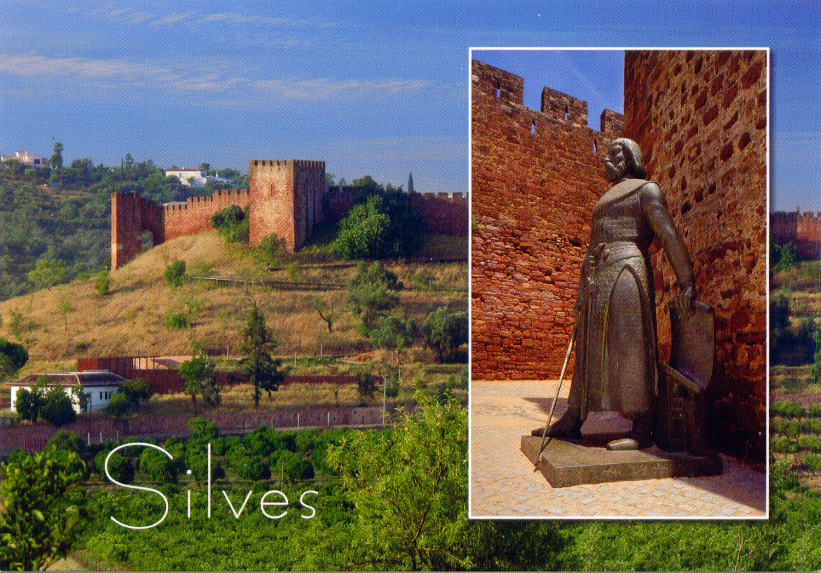
1390 PORTUGAL (Faro) - Castle of Silves

$
0
0

Situated on a hill above the Arade River, navigable in historical times, and bordered to the south by the Atlantic Ocean, Silves was possibly founded during the times of Roman domination. Former capital of the Algarve, it was one of the most important towns of western Al-Andalus. Silves Castle (Castelo dos Mouros, Moorish Castle), located on the top of the hill and built between the 8th and 13th century, is one of the best preserved of the Moorish fortifications in Portugal. In the next hundred years, the fortification was strengthened by Moors and passed twice, for brief periods, under Christian dominion, until  Afonso III of Portugal definitively conquered it.

Read more »

1391 UNITED STATES (Alabama) - The map and the flag of the State of Alabama

$
0
0

Bordered by Tennessee to the north, Georgia to the east, Florida and the Gulf of Mexico to the south, and Mississippi to the west, Alabama (nicknamed The Cotton State) took its name from the Alabama people, a Muskogean-speaking tribe whose members lived just below the confluence of the Coosa and Tallapoosa rivers. About three-fifths of its land area is a gentle plain, and the north region is mostly mountainous, with the Tennessee River cutting a large valley and creating numerous creeks, streams, rivers, mountains, and lakes. The capital city of the state is, from 1846, Montgomery, which was also selected in 1861 as the first capital of the Confederate States of America, until the seat of government moved to Richmond, Virginia.

Read more »

1392 TAIWAN - Queen's Head in Yehliu Geopark

$
0
0

Located in the town of  Wanli, New Taipei, Yehliu Promontory stretches approximately 1,700m into the ocean and was formed as geological forces pushed Datun Mountain out of the sea. A distinctive feature of the cape is the hoodoo stones that dot its surface. A number of rock formations have been given imaginative names based on their shapes. The best known is the Queen's Head, an iconic image in Taiwan and an unofficial emblem for the town of Wanli. Other formations include the Fairy Shoe, the Beehive, the Ginger Rocks, and the Sea Candles.

Read more »

1393 INDONESIA (Lesser Sunda Islands) - Naga Banda in Ngaben Ceremony

$
0
0

Ngaben, or Cremation Ceremony, is a Hindu funeral ritual performed in Bali to send the deceased to the next life. The body of the deceased is placed as if sleeping, and the family continues to treat him as sleeping. No tears are shed, because the deceased is only temporarily absent and will reincarnate or find final rest in  Moksha. To find out the proper day of the ceremony, is consulted a specialist. In this day, the body is placed inside a coffin, placed in its turn inside a sarcophagus resembling a buffalo (Lembu) or in a temple structure (Wadah), made of papier-maché and wood. The sarcophagus is then borne to the cremation site in a procession, which is almost never walked in a straight line, to confuse the evil spirits.

Read more »

1394 UNITED STATES (New York) - Esopus Meadows Lighthouse

$
0
0

Nicknamed Maid of the Meadows, and located on the Hudson River, near the town Esopus (which took its name from the native Esopus tribe), Esopus Meadows Lighthouse stands on the west side of the channel, in the river, and is accessible only by boat. Its purpose was to warn mariners of the mud flats known as the Esopus Meadows, located off the western shore of the river, and its construction began in 1838, when the land was ceded for $1.00 by the town to the US government. The light became active in 1839, and was a twin to the Roundout II lighthouse further north up the river. By 1867, the building was heavily damaged by flood and ice and funds for a new lighthouse were appropriated in 1870.

Read more »

1395 SWEDEN (Stockholm) - The old town hall in Sigtuna

$
0
0

Located not far to Stockholm, at the bay Skarven, Sigtuna is a locality with only approximately 8,500 inhabitants, but, although less significant today, it has an important place in Sweden's early history, because is the oldest inhabitat town in the country, founded in 980. It operated as a royal and commercial centre for some 250 years, and was one of the most important cities of Sweden. During a brief period at the end of the 10th and beginning of the 11th century, Sweden's first coins were minted here. St. Mary's Church, built in the 13th century by the Dominican order, still remains largely intact.

Read more »

1396 UNITED KINGDOM (British Antarctic Territory) - Port Lockroy Historic Site

$
0
0

Port Lockroy is a natural harbour on the north-western shore of Wiencke Island in Palmer Archipelago, a group of islands off the northwestern coast of the Antarctic Peninsula, the northernmost part of the mainland of Antarctica. It was discovered in 1904 and named after Edouard Lockroy, a French politician who assisted Jean-Baptiste Charcot in obtaining government support for his French Antarctic Expedition. After the harbour was used for whaling between 1911 and 1931, during WWII the British military Operation Tabarin established the Port Lockroy base (Station A) on tiny Goudier Island in the bay. The chief reason of this operation was to establish solid British claims to various uninhabited islands and parts of Antarctica, reinforced by Argentine sympathies toward Germany.

Read more »

1397-1401 UNITED STATES (Illinois) - Chicago Skyscrapers

$
0
0

In the 1770s, the Haitian-born Jean Baptiste Point du Sable established a fur trading post in the area which later became known as Fort Dearborn, along the bank of the Chicago River. In 1837, the settlement had a little more than 3,500 inhabitants and was incorporated as a city. Located near a portage between the Great Lakes and the  Mississippi River watershed, Chicago emerged as an important transportation hub between the eastern and western United States, becoming the fastest growing city in the world for several decades. After the Civil War ended in 1865, the American economy was transformed by the industrial revolution, in which the city of Chicago was its leader, becoming America’s second largest city and a leading industrial center. In the 1890’s alone, the city’s population increased by 600,000 people alone.


The Great Chicago Fire, which destroyed most buildings within the downtown area, led to the largest building boom in the history of the nation. In 1885, the first steel-framed high-rise building, the Home Insurance Building, rose in the city as Chicago ushered in the skyscraper era. Moreover, the city gave its name to the Chicago School and was home to the Prairie School, two movements in architecture, being able to say that the architecture of Chicago has influenced and reflected the history of American architecture. Numerous architects have constructed landmark buildings of varying styles in city. Some of these are the so-called "Chicago seven":  James Ingo Freed, Tom Beeby, Larry Booth, Stuart Cohen, James Nagle, Stanley Tigerman, and Ben Weese. Today, the city's skyline is among the world's tallest and most dense.


Willis Tower - built as and still commonly referred to as Sears Tower, is a 108-story, 442m skyscraper completed in 1973. It surpassed the World Trade Center towers in New York to become the tallest building in the world, a title held for nearly 25 years. As of December 2013, the Willis Tower is the second-tallest building in the United States and the eighth-tallest freestanding structure in the world. Its innovative design, structurally efficient and economic, inspired by an advertisement for a package of cigarettes, was realised by the architect Bruce Graham and structural engineer Fazlur Rahman Khan (Skidmore, Owings & Merrill), who used for the first time bundled tube structure. The tower's observation deck (the Skydeck), located on the 103rd floor, is 412m high and is one of the most famous tourist attractions in Chicago.


Presidential Towers - is a series of four nearly identical towers with 49 storeys (141m), each a step back from the leader, and spanning two city blocks. Designed by Solomon Cordwell Buenz & Associates and built between 1985 and 1986, it was one of the pioneering residential projects in the River West neighborhood, an area that was once seen as nothing more than a ramshackle collection of old brick warehouses.

333 West Wacker Drive - is an office building with a height of 149m, designed by Kohn Pederson Fox Associates and completed in 1983. On the side facing the Chicago River, the building features a curved green glass façade, while on the other side the building adheres to the usual rectangular street grid. It’s not the tallest, or the most expensive, but it is still one of the superstars of the Chicago skyline.


James R. Thompson Center - houses offices of the Illinois state government. The building opened in 1985 as the State of Illinois Center was renamed in 1993 to honor former Illinois Governor James R. Thompson. The property takes up one of the 35 full-size city blocks within Chicago's Loop. It was designed by Murphy/Helmut Jahn and opened to mixed reviews by critics, ranging from "outrageous" to "wonderful". The 17-storeys, all-glass exterior does not reflect the building's function, and instead conveys an image of pure postmodernism.

Read more »

1402 ZIMBABWE - Wooden Carvings

$
0
0

Zimbabwe is an ethnically diverse country, but the Shona, the Bantu people considered the oldest in the region (are believed to be the legendary guardians of King Solomon's mines) holds an overwhelming majority of 70%. They are known as skilful and creative sculptors, Zimbabwe being considered the center for stone sculpture in Africa. Besides stone, they also use wood, mainly Ebony, African Teak, and Mukwa. The sculptures depicted in the postcard seem to be made of Mukwa, which is only found in Tanzania, ZambiaMozambique, Zimbabwe and South Africa. It has variable colors such as a pale uniform brown, chocolate brown, brick red or purplish brown and golden brown. The two men depicted in sculptures wear sumptuous headdresses and play drums, probably a ngoma(the one supported on earth), and a calabash(the one hemispherical).

Read more »

1404 BANGLADESH - Mahansthangarh and its Environs (UNESCO WHS - Tentative List)

$
0
0

Located 11km north of Bogra, Mahasthangarh, the ancient capital of Pundravardhana, home of the Pundra, a group of people not speaking languages of the Indo-European family, is one of the earliest urban archaeological sites so far discovered in Bangladesh. Mahasthan means a place that has excellent sanctity and garh means fort. A limestone slab bearing six lines in Prakrit in Brahmi script, discovered in 1931, dates Mahasthangarh to at least the 3rd century BC, and the fortified area was in use till the 18th century AD. The site is protected by the Karatoya River (now only a small stream) on the west and a deep moat on the south, west and part of the north.

Read more »

1405 GHANA - The map of Ghana

$
0
0

Bordered by the Ivory Coast in the west, Burkina Faso in the north, Togo in the east and the Gulf of Guinea and Atlantic Ocean in the south, Ghana (which means "Warrior King") was the first African nation to declare independence from European colonisation, in 1957. Located only a few degrees north of the Equator, it is geographically closer to the "centre" of the Earth than any other country (the notional centre is located in Atlantic, at approximately 614km off the south-east coast of the country). It can be divided into four different geographical ecoregions. The coastline is mostly a low, sandy shore backed by plains and scrub and intersected by several rivers while its northern part features high plains. South-west and south-central is made up of a forested plateau region consisting of the Ashanti uplands and the Kwahu Plateau. The hilly Akwapim-Togo ranges are found along Ghana's eastern border. On its territory is the Lake Volta, the world's largest artificial lake.

Read more »

1406 ROMANIA (Maramureş) - Vaser Valley Mocăniţa

$
0
0

A Mocăniţă is a narrow gauge railway in Romania (most notably in mountainous areas in  Maramureş, Transylvania, and Bukovina), and the locomotives operating on them. The word mocăniţă is a term of endearment, derived from the Romanian word mocan (meaning shepherd or one who lives in the mountains), and suffixed as feminine and diminutive. Many of these forestry railways were built in the era of the  Austro-Hungarian Empire, especially in the Carpathian Mountains. They followed the rivers, often necessitating tight curves, hence the use of the narrow gauge. The tracks were constructed so as to enable small locomotives to pull empty logging wagons up into the mountains and to let heavily loaded trains roll down under gravity to the saw mills.

Read more »

1407 UNITED STATES (Washington) - The map of the State of Washington

$
0
0

Washington is that State located in the upper left corner on the map of the United States, bordered by Oregon on the south, Idaho on the east, the Canadian province of British Columbia on the north, and the Pacific Ocean on the west, not too large nor too small, not too populated nor too uninhabited. That if we talk about average, because if we consider that half of the population is concentrated in Seattle metropolitan area (over 3.6 million inhabitants), the things are changing. Admitted to the Union in 1889 as the 42nd state, Washington remained for long time a forest county, the demand for timber being the one which dictated its economic increase or decrease until WWII, when the place of the forest industry was taken by Boeing Company. It's famous the Skid Road (the road for the timber transport with Seattle as a starting point), became within one generation Skid Row, an proverbial area in America in '90s through his poverty and promiscuity.

Read more »
Viewing all 2426 articles
Browse latest View live