Quantcast
Channel: WORLD, COME TO MY HOME!
Viewing all 2426 articles
Browse latest View live

1033 SPAIN (Cantabria) - Cave of Altamira and Paleolithic Cave Art of Northern Spain (UNESCO WHS)

$
0
0

The Altamira cave, located near the town of Santillana del Mar, 30 km west of the city of Santander, was well known to locals, but had not been given much attention until in 1868, when it was "discovered" by the hunter Modesto Peres. Seven years later, the amateur archaeologist Marcelino Sanz de Sautuola started its exploration, and in 1879 his daughter Maria, nine years old at the time, noticed that the ceiling was covered by images of bisons. Sautuola rightly assumed that the paintings might date from the Stone Age, and engaged an archaeologist from the University of Madrid to help him. Their interpretation that the paintings dates from Paleolithic, was derided by the French specialists, Sautuola being even accused of forgery. Only in 1902 the scientific society retracted their opposition to the Spaniards, but Sautuola had died 14 years earlier, and didn't live to enjoy the restitution of his honour.

Read more »

0166 & 1034 UNITED ARAB EMIRATES (Dubai) - Burj Al Arab, "the power of excessive wealth"

$
0
0

Posted on 06.04.2012, 16.03.2014
The first postcard is very representative and suggestive for the current state of the emirates, combining in a appropriate way the past, the present, and even the future. I said here that in Dubai is the world's only Seven-Star hotel (officially rated Five-Star Deluxe). It's about Burj Al Arab (Tower of the Arabs), which, with its 321m, it's now the fourth tallest hotel in the world. For a decade, since its opening in 1999, until the inauguration of the Rose Rayhaan by Rotana, was the tallest, being exceeded also since then by the JW Marriott Marquis Hotel Dubai (2013) and The Ritz-Carlton Hong Kong (2011). It was built on an artificial island 280m out from Jumeirah beach, and is connected to the mainland by a private curving bridge. Its shape was designed by architect Tom Wright of WS Atkins PLC to mimic the sail of a dhow, a type of Arabian vessel. Two "wings" spread in a V to form a "mast", while the space between them is enclosed in a massive atrium (182m), also the tallest in the world. The wide open balconies flank two sides of te atrium. At the front of the building, and forming the third wall to the atrium, is a geometric double-skin membrane of PTFE-coated fibreglass, which both helps to insulate the atrium space and acts as a canvas for images projected onto the face of the hotel.


At night it's illuminated by choreographed lighting representing water and fire. The hotel have also two restaurants, Al Muntaha (Highest or Ultimate), located 200m (660 ft) above the Persian Gulf, and Al Mahara (Oyster), which is accessed via a simulated submarine voyage, and features a huge seawater aquarium, holding 9,900,000 l. Despite its size, the hotel holds only 28 double-story floors which accommodate 202 bedroom suites. The smallest occupies an area of 169 m2, and the largest covers 780 m2. Three-room apartment where I live has less than 100m2. Prices of rooms vary from approximately $1,000 to $27,000 per night. If I sell the apartment, maybe I would be able to sleep two nights at the Burj Al Arab. What you can offer a hotel in exchange for $ 27,000 I don't know and, frankly, even if I could afford, I wouldn't have the curiosity to find out on my own skin. But you can get an idea visiting the official site of the hotel.

Read more »

1035 UNITED STATES (California) - The GS-5 steam locomotive No. 4459 in 1953, in Los Angeles

$
0
0

This is the first postcard about which there was no need to search informations, because what it is written on its back it is more then enough:

"Four years before this great picture was taken, reproducing the glamorous, glory-days of steam, when a LimaSouthern Pacific"Northern" waltzed a shiny red-orange-and-black Coast Daylight out of Los Angeles - on April 12, 1953 - just four years earlier there were trains prancing all over the Coast Route. She was then the Morning Daylight, this No. 99, this proud beauty - and acknowledged money-maker. There was also a sister train, the Noon Daylight, out of L.A. at a quarter past noon - because this service was so popular. The swank all-Pullman Park skirted the Coast Line at night. Even the well-known Coaster, Nos. 69 and 70, ran in those wonderful days. And 71 and 72, lowliest rattler of all, but once displaying those haughty numerals on the original Daylight Limited in pre-streamlining days - she sill ran.

Read more »

1036 MONGOLIA - The Traditional Naadam festival (UNESCO ICH)

$
0
0

Naadam (literally "games") is a traditional festival in Mongolia (but also in China, in areas in which live Mongols), termed locally Eriin gurvan naadam (the three games of men), which exist, probably, for centuries. The biggest festival (Naadam of the Country) is held in the capital Ulan Bator during the National Holiday from July 11-13, in the National Sports Stadium. It begins with an elaborate ceremony featuring dancers, athletes, horse riders, and musicians, after that follows the competitions in the three games, directly linked with the lifestyles and living conditions of the Mongols: Bökh(Mongolian wrestling), horse racing and archery. Genghis Khan's nine yak tails, representing the nine tribes of the Mongols, are still ceremonially transported from Sukhbaatar Square to the Stadium to open the festivities. Another popular Naadam activity is the playing of games using shagai, sheep anklebones that serve as game pieces and tokens of both divination and friendship. In 2010, Naadam was inscribed by UNESCO on the Representative List of the Intangible Cultural Heritage of Humanity.

Read more »

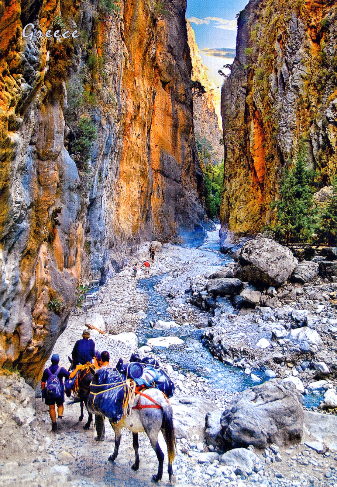
1037 GREECE (Crete) - Gorge of Samaria National Park (UNESCO WHS - Tentative List)

$
0
0

Crete, the largest of the Greek islands, once the center of the Minoan civilization, is mountainous and a land of gorges, the most glamorous being Samariá Gorge, the symbol of the island, which holds a unique and distinguished position in Cretan, Greek and Mediterranean history. Created by a small river running between the White Mountains (Lefká Óri), the largest mountain range of Crete, which dominate the southwest part of the island, and Mount Volakias, it is also identified with the unceasing production of the material and immaterial cultural heritage of Crete through the ages.

Read more »

1038 GUYANA - St. Georges Anglican Cathedral (UNESCO WHS - Tentative List)

$
0
0

Located on Church Street in Georgetown, the capital city of Guyana, this Anglican cathedral, designed by Sir Arthur Blomfield, was consecrated in 1894. At the beginning, the architect Arthur Blomfield designed the plans of a cathedral in stone, with a central tower and two western towers, but these were rejected because of the weight and the expense. His subsequent plans for a wooden cathedral were accepted, a design that kept many of the salient features of his first plan, such as the central tower and the Latin cross formation of nave and transepts. It is characterised mainly by Gothic arches, clustered columns and flying buttresses, but it also has a tropical flavour, ensuring light and air. The interior of the church makes for fascinating history. Any object or structure tell a story, not only about Guyana's history, but glimpses of its Caribbean neighbours are also revealed. A large chandelier, a gift from Queen Victoria, hangs prominently within the cathedral. The wooden Centenary Cross in front of the High Altar marks the 100th anniversary of the Province of the West Indies, founded in 1883.

Read more »

1039 CROATIA (Dubrovnik-Neretva) - Historical-town planning ensemble of Ston with Mali Ston, connecting walls, the Mali Ston Bay nature reserve, Stonsko Polje and the salt pans (UNESCO WHS - Tentative List)

$
0
0

The fertile fields and large protected bays of the south of isthmus of the Pelješac peninsula, where is located the municipality of Ston, favoured always the human settlements, as proved the archaeological excavations, which brought to light a variety of cultural layers since prehistory through antiquity, the Middle Ages to the present day. The sites of the Ston region, blended inseparably with the natural framework, make up a universal civilizational value and link between Nature and Man, and assert the regions and the 2000 years of its history.

Read more »

1040 UNITED STATES (Hawaii) - Merrie Monarch Festival

$
0
0

The early settlement history of Hawaii isn't completely resolved. One hypothesis is that the first Polynesians arrived in Hawaiʻi in the 3rd century from the Marquesas and were followed by Tahitians in 1300, who conquered the original inhabitants. Another is that a single, extended period of settlement populated the islands. Whatever the truth, the fact is that the Native Hawaiians (kānaka maoli) are Polynesian as origin, and their culture is a clear evidence in this regard, even if the different ethnic groups who established on the islands during the past 200 years added elements of its own culture.

Read more »

1041 RUSSIA - A family in traditional clothes

$
0
0

The area now called Russia has always been multicultural. Russian culture started from that of the East Slavs, with their pagan beliefs and specific way of life in the wooded areas of Eastern Europe. It was influenced first by neighbouring Finno-Ugric tribes and by nomadic, mainly Turkic, peoples of the Pontic steppe, then by the Varangians. Kievan Rus' had accepted Orthodox Christianity in 988, and this largely defined the Russian culture of next millennium as the synthesis of Slavic and Byzantine cultures. A gradual process of the melding of pre-Christian practices with those of Orthodoxy consolidated the population which occupied present-day Russia, Ukraine, and Belarus under one political and cultural system.

Read more »

1042, 1043 POLAND (Subcarpathia) - Baranów Sandomierski Castle

$
0
0

Located in southern Poland, on the central section of the Vistula River, the small town Baranów Sandomierski, first mentioned in 1135, was an important center of Calvinism during the Protestant Reformation, and experienced a short period of prosperity before the catastrophic Swedish invasion of Poland (1655 - 1660), when was ransacked and burned. It is well known for its picturesque Renaissance castle, surnamed as "little Wawel". Built around 1591-1606 for Andrzej and Rafał Leszczyński in Poland's Mannerism style, it is the work of the famous architect Santi Gucci, the court artist of King Sigismund II Augustus.


In 1620 the castle was surrounded by bastion fortifications and in 1625 its chambers were adorned with early Baroque decorations. On the end of the 17th century it came into the possession of the Lubomirski family. Prince Józef Karol Lubomirski added the western wing gallery and embellished the interiors with profuse late-baroque stucco decorations. The gallery housed their collection of art, destroyed in massive fires, first in 1848 and finally in 1898. Then the structure was restored by Stanisław Dolański, under the direction of the Cracovian architect Tadeusz Stryjeński. The Chapel was decorated with the impressive stained-glass windows of  Józef Mehoffer as well as an altar with the exceptional painting by Jacek Malczewski"Immaculate Mother of God". It remained in the possession of the Dolański family till the outbreak of WWII.

Read more »

0092, 0171, 0534, 1004, 1005, 1044 CAMBODIA (Siem Reap) - Angkor (UNESCO WHS)

$
0
0

Posted on 06.01.2012, 14.04.2012, 02.03.2013, 16.02.2014 and 03.04.2014
Subjected to the Indian influences, passed through filters Thai or Lao, for more than 1,000 years, the Khmer have created firstly kingdoms of Funan and Chenla, to achieve peak during the Khmer Empire (centuries 9th-15th), of which greatest material legacy is Angkor, the site of the capital city during the empire's zenith. The spiritual legacy is Theravada Buddhism, introduced to the area through monks from Sri Lanka in the 13th century, considered for centuries an esential element of the khmer's ethnic and cultural identity. If about the early days of the empire we don't know too much, after the 13th century Angkor was visited by many travelers, starting with chinese Zhou Daguan and continuing with Portuguese and Spanish missionaries. The Khmer already constructed the most important architectural masterpieces in the area known as Angkor, the largest preindustrial city in the world, with more than one million inhabitants. .Angkor, located to the north of the Great Lake (Tonlé Sap) and south of the Kulen Hills, near modern-day Siem Reap, is a UNESCO World Heritage Site from 1992.

The principal temple, Angkor Wat (in the first three postcards), was built between 1113 and 1150 by King Suryavarman II, as his personal temple mausoleum. It’s the world's largest religious building and it has become a symbol of Cambodia, appearing on its national flag. Very well preserved, it’s the only one to have remained a significant religious centre since its foundation - first Hindu, dedicated to the god Vishnu, then Buddhist. The most comprehensive presentation of the temple and the most easily accessible to a wide public seems to be that of The Monuments of the Angkor Group by Maurice Glaize, published in 1944 in Saigon. I will quote only a few short, but representative fragments, a "snack" if you like:


"Angkor may be visited in all seasons. However the most favourable period extends from November to March, during the first months of the dry season, when the temperature is particularly clement. […] It is preferable, particularly in the hot season, to leave early in the morning and to return before eleven o'clock, and not to revisit in the afternoon until three or four o'clock - the light at the end of the day being generally more favourable. The majority of the monuments - and in particular Angkor Wat - lose much in being viewed against the light. […] We would especially recommend the setting of the sun at Angkor Wat, where sometimes the spectacle will include the flight of the bats in the fading light, or from the top of Phnom Bakheng or Phnom Krom, or the terrace of the Srah Srang - or else from the beach of the baray, where the bathing is delightful. Finally, if you have the opportunity, do not miss, by the light of the full moon, the second level courtyard of Angkor Wat at the foot of the central tower, or the upper terrace of the Bayon."

"Constructed to the south of the capital (Angkor Thom), Angkor Wat is sited in the south-east corner of the ancient city of Angkor - Yasodharapura - built by Yasovarman I, centred on Phnom Bakheng and which stretched between the Siem Reap river to the east and the dike of the baray to the west. […] Isolated from the forest by its moats, Angkor Wat was, of all the monuments of the group, the best placed to escape the invasion of the jungle and hence ruin. Moreover, following the establishment of Buddhism of the small vehicle, it has always sheltered pagodas, as a place of pilgrimage for the Khmer, within its enclosure - though at one time partially masking the main façade these had to be re-sited in order not to detract from the overall perspective."


Another very interesting work that talks also about Angkor is Voyage dans les royaumes de Siam, de Cambodge, de Laos et autres parties centrales de l'Indo-Chine (Travels in the Central Parts of Indo-China, Cambodia and Laos During the Years 1858,1859, and 1860), by Henri Mouhot, published in 1863 in Paris. Mouhot is the one who popularized Angkor in the West, naming it "the work of the King of Angels."


In the fourth postcard are two Apsaras, females spirits of the clouds and waters in Hindu and Buddhist mythology (also known as Vidhya Dhari or Tep Apsar in Khmer, which means "nymph" or "celestial maiden"). Beautiful, youthful and elegant, often the wives of the Gandharvas (the court musicians of Indra), Apsaras are superb in the art of dancing, seducing equally gods and men. As caretakers of fallen heroes, they may be compared to the valkyries of Norse mythology, and as ethereal beings often depicted taking flight, to angels, but sometimes are also compared to the muses of ancient Greece. Probably due to the association with water, they are able to change their shape at will. Apsaras represent an important motif in the stone bas-reliefs of the Angkorian temples, but not all female images are considered to be apsaras, the ones who have static attitude being called devatas. Angkor Wat features both apsaras and devatas, but the devatas are the most numerous. Khmer classical dance, the indigenous ballet-like performance art, is frequently called "Apsara Dance" and reflects one of the origin myths in Cambodia, depicting the union of Mera, a celestial dancer, and Kambu, a wise man.


Built in the late 12th century or early 13th century as the official state temple of the Mahayana Buddhist King Jayavarman VII, the Bayon Temple (in the fifth postcard) stands at the centre of Jayavarman's capital, Angkor Thom, meaning the intersection of heaven and earth. Following Jayavarman's death, it was modified and augmented by later Hindu and Theravada Buddhist kings in accordance with their own religious preferences. Bayon is known for its huge stone faces of the bodhisattva Avalokiteshvara, with one facing outward and keeping watch at each compass point. The curious smiling image, thought by many to be a portrait of Jayavarman himself, has been dubbed by some the "Mona Lisa of Southeast Asia." There are 51 smaller towers surrounding Bayon, each with four faces of its own. The temple is known also for two impressive sets of bas-reliefs, which present an unusual combination of mythological, historical, and mundane scenes. I have to appeal again to the book The Monuments of the Angkor Group, comprehensive and accessible:


"Separated by less than a century, the Bayon is the antithesis of Angkor Wat. While this latter sits at ease in its successive enclosure walls, realising according to a spacious plan a vast architectural composition through the harmonious equilibrium of its towers and its galleries, the Bayon, enclosed within the rectangle of 140 metres by 160 that constitutes its third enclosure (the gallery of the bas-reliefs), gives the impression of being compressed within a frame which is too tight for it. Like a cathedral built on the site of a village church, its central mass is crammed into its second gallery, of 70 metres by 80, in a jumbled confusion of piled blocks."[…]

Read more »

1016, 1017, 1045 RUSSIA (Krasnodar Krai) - Venues of the 2014 Winter Olympics and Paralympics

$
0
0

Posted on 28.02.2014, 05.04.2014
Located on the Black Sea coast, near the Caucasus Mountains, not far from the border with Georgia / Abkhazia, Greater Sochi area sprawls for 145 kilometers and is Federation's largest resort city. It is one of the very few places in Russia with a subtropical climate, with warm to hot summers and mild winters. Anyway, Russia conquered this coastline only in 1829, and since 1866, after the Circassian Genocide, the area was actively colonized by Russians, Armenians, Ukrainians, and other people from inner Russia. Sochi was established as a fashionable resort area under Stalin, and following the loss of the popular resorts of the Crimean peninsula in favor of Ukraine, it emerged as the unofficial summer capital of the country. During Vladimir Putin's term in office, the city witnessed a significant increase in investment, and, as everybody know, this year hosted the XXII Olympic Winter Games (7-23 February 2014), the most expensive in history, with a budget of US$51 billion. The events were held around two clusters of new venues: an Olympic Park constructed in Sochi's Imeretinsky Valley on the coast of the Black Sea, and the Games' indoor venues located within walking distance, and snow events in the resort settlement of Krasnaya Polyana.


Sochi Olympic Park (Coastal Cluster)
The Adler Arena Skating Center (the first postcard), an 8,000-seat speed skating oval opened in 2012, looks like an iceberg or ice fault. After the Olympics, it was turned into an exhibition center. A crystal face theme is supported by angular walls and triangular stained-glass windows. The gray and white color of the building enhances this impression. The walls along the sides of the skating rink are made transparent so that spectators can look outside. The skating center is designed to make the utmost use of local natural features. The Ice Cube Curling Center (the second postcard) is a 3,000-seat multi-purpose arena, opened also in 2012. After the games, it remained a sports arena, mainly that this venue is a portable one and may be re-located. It is simplistic in design, which symbolizes democracy, and accessibility alongside the festivity.


Krasnaya Polyana (Mountain Cluster)
The Laura Biathlon & Ski Complex (the third postcard) is a skiing venue located on the crests and slopes of Psekhako Ridge, within 6.5-10 km far to the North-Ester of Krasnaya Polyana. The Center includes two isolated stadia, each with their own start and finish zones, two isolated track systems for Skiing and Biathlon, shooting area and warm-up zones. It hosted the biathlon and the cross-country skiing portion of the Nordic combined events. Seating 7500 at both the biathlon and the cross country skiing areas, it was first used in June 2013.

Read more »

1046 TURKEY (Aegean Region) - Didyma

$
0
0

Didim, a small town and a popular seaside holiday resort on the Aegean coast, on the north shore of the gulf of Güllük, is home of the antique city of Didyma with its Temple of Apollo, the Didymaion. Next to Delphi, Didyma was the most renowned oracle of the Hellenic world, first mentioned in the Homeric Hymn to Apollo, and also the largest and most significant sanctuary on the territory of the great classical city Miletus. To approach it, visitors would follow the Sacred Way to Didyma, about 17 km long. Along the way, were ritual waystations, and statues of members of the Branchidae family, as well as animal figures. Some of these statues, dating to the 6th century BC are now in the British Museum, taken by Charles Newton in the 19th century.

Read more »

UNITED STATES (Hawaii) - Kauai

$
0
0

Kauai (or Kauaʻi), the oldest and northernmost island in the Hawaiian chain, the fourth largest of the archipelago, was formed by the passage of the Pacific plate over the Hawaii hotspot, with six million years old ago. Discovered by Captain James Cook in 1778, it was one of the last islands which joined the Kingdom of Hawaiʻi, during the reign of King Kamehameha. Draped in emerald valleys, sharp mountain spires and jagged cliffs, it is justly surnamed the Garden Isle. Kauai's most striking geographic feature is the Nā Pali Coast State Park (on the first postcard), located in the center of the rugged 26 km along the northwest side of the island. Result of millions of years of wind and water erosion, it stretch southwest starting at Keʻe Beach until the Polihale State Park, and is formed of high cliffs (na pali), which rise until 1.200 m hight along the shoreline, but also of green valleys, towering waterfalls and hidden sea caves. These breathtaking cliffs can only be seen from the sea, by air or by hiking the Kalalau Trail, which runs 18 km and crossing five major valleys before reaching Kalalau Beach at the base of Kalalau Valley.


Actually the Nā Pali Coast State Park was formed to protect the Kalalau Valley (on the second postcard), surrounded by lush cliffs more than 610 m high, and renowned for its natural beauty. The valley bottom is broad and relatively flat, with an accessible region about 3 km long and almost 1 km wide. The abundant sun and rain provides an ideal environment for flora and fauna. Many native Hawaiians lived in the valley into the 20th century, farming taro from a vast complex of terraced fields. Unfortunately these terraced gardens are being threatened and destroyed by the introduced and invasive trees, which created an extensive underground root network which quickly invaded the traditional rock walls of the terraces. The valley is also home to many rare species, including the endangered plant Dubautia kalalauensis which was named for the valley and is found nowhere else in the world. Other endemics include the endangered Schiedea attenuata.


To the east of the Nā Pali Coast State Park is the Hono O Nā Pali state Natural Reserve. Hiking trails and hunters roads have access to the sharp ridges from Koke Road in Waimea Canyon (16 km long and up to 900 m deep - on the third postcard), also known as the Grand Canyon of the Pacific. Waimea is Hawaiian for "reddish water", a reference to the erosion of the canyon's red soil. It has a unique geologic history, because it was formed not only by the steady process of erosion, but also by a catastrophic collapse of the volcano that created Kauaʻi. Roughly 4 million years ago, while Kauaʻi was still erupting, a portion of the island collapsed, forming a depression, which then filled with lava flows. In the time since, rainwater from the slopes of the island's central peak (Mount Waiʻaleʻale, which is among the wettest places on earth) have eroded Waimea Canyon along one edge of the collapse.


Polihale State Park (on the fourth postcard) is a remote wild beach on the western side of the island, on the south of the Na Pali Coast mountain ridges, and even if is several kilometers long, offers safe swimming only in the area known as Queen's Pond, a shallow pond with a sandy bottom surrounded by a protecting reef, located at the southern end. It is kilometers away from the town of Kekaha and can only be reached via a poorly marked, dirt sugarcane road. Sand dunes along the beach can reach heights nearing 30 m. South of Queen's Pond is Barking Sands Beach, also known as Keonekani o Nohili (The Sounding Sands of Nohili). If one walks over the sand here or takes two handfuls of sand in each hand and slaps it together, a sound is produced. This phenomenon occurs due to the formation of the individual sand grains, each of them having small holes in it, and the sound is produced within these small cavities through the vibrations that occur when the sand is pushed together.


Kīlauea Point National Wildlife Refuge (on the fifth postcard) is located on the northwest coast of the island, established in 1985 to preserve and enhance seabird nesting colonies after the property was transferred from the United States Coast Guard. On Kīlauea Point, a narrow, lava peninsula, is located Kīlauea Lighthouse, dedicated in 1913, and built in a Classical Revival architecture style out of reinforced concrete. The tower is a slightly tapering cylinder about 16 m high. The lens one of only seven second-order Fresnel lenses remaining in a lighthouse in the US. Barbier, Bernard, and Turenne manufactured the lens in Paris, France. The 4,100 kg lens floated on mercury and compressed air, and was rotated by a system of pulleys powered by weights that needed to be reset by an operator every 3.5 hours. A radio beacon was added in 1930, and with the added generator the light was changed to be powered by electricity. The station was manned until 1974 when it was automated. In February 1976 the light was moved to a nearby smaller tower and the tower was sealed.

Read more »

0701, 1052 ITALY (Veneto) - City of Verona (UNESCO WHS)

$
0
0

Posted on 27.06.2013, 07.04.2014
At the time when was happening the action of Romeo and Juliet by William Shakespeare, Verona reached its maximum prosperity, under the rule of the Scaliger family and particularly under Cangrande I, who protected the exiled poet Dante. Situated at the foot of Monte Lessini on the River Adige, in northern Italy, the city became important because it was at the intersection of several roads. Founded by ancient tribes and became a Roman colony in the 1st century BCE, was occupied by the Ostrogoths, by the Lombards, and by Charlemagne (774). In the early 12th century, it became an independent commune, but it fell to Venice in 1405, was part of the Austrian Empire from 1797, and joined the Kingdom of Italy in 1866. Because is an outstanding example of a town that has developed progressively and uninterruptedly over 2,000 years, incorporating artistic elements of the highest quality from each succeeding period, was designated an UNESCO World Heritage Site in 2000.


The core of the city consists of the Roman town, which includes the Porta Borsari, the Porta Leoni, the Arco dei Gavi, the Ponte Pietra, the Roman theatre (excavated in the mid-19th century and restored for use in spectacles), and the Amphitheatre Arena (the second-largest after the Colosseum in Rome). The Scaligers rebuilt the walls, embracing a much larger territory in the west and another vast area on the east bank of the river. The heart of Verona is the ensemble consisting of the Piazza delle Erbe (with its picturesque vegetable market) and the Piazza dei Signori, with their historic buildings, including the Palazzo del Comune, Palazzo del Governo, Loggia del Consiglio, Arche Scaligere and Domus Nova. The Piazza Bra has a number of classicist buildings.

Read more »

1055 VIETNAM - Only demons have white teeth?

$
0
0

The areca nut is the seed of the areca palm (Areca catechu), which grows in much of the tropical Pacific, Asia, and parts of east Africa. It is commonly referred to as betel nut (even if it isn't a true nut, but rather a drupe), as it is often chewed wrapped in betel leaves, a custom which dates back thousands of years in much of the areas from South Asia eastward to the Pacific. Usually for chewing, a few slices of the nut are wrapped in a betel leaf along with lime (not to be confused with the citrus fruit named lime) and may include clove, cardamom, catechu (kattha) and/or other spices for extra flavouring. Betel leaf has a fresh, peppery taste, but it can also be bitter to varying degrees depending on the variety. This mixture is a mild stimulant, causing a warming sensation in the body and slightly heightened alertness, much like a cup of coffee. Even though it seems to have some positive effects on health, the custom is suspected to be carcinogenic.

Read more »

1056 RUSSIA (Republic of Karelia) - The Valamo archipelago - The Saviour Transfiguration Cathedral (UNESCO WHS - Tentative List)

$
0
0

Valaam (also known by the Finnish name Valamo) is an archipelago in the northern portion of Lake Ladoga, best known for its more than 200 relicts of the past. In the 12th century, the islands were a part of the Novgorod Republic. In the 17th century they were captured by Sweden, but Russia reconquered them less than a century later. When the Grand Duchy of Finland was set up as an autonomous part of the Russian Empire, Valaam became part of Finland. In 1917, they became a part of newly independent Finland, but it was acquired by the USSR after the Winter War and Continuation War.

Read more »

1057 UNITED STATES (Wyoming) - The map of State of Wyoming

$
0
0

Placed between Montana, South Dakota, Nebraska, Colorado, Utah, and Idaho, Wyoming is one of the three states (along with Colorado and Utah) which have borders along straight latitudinal and longitudinal lines. The western two thirds of the state is covered mostly with the mountain ranges and rangelands in the foothills of the Eastern Rocky Mountains, while the eastern third of the state is high elevation prairie known as the High Plains. Following, is the second least densely populated of the 50 United States, after Alaska. Its capital and its most populous city is Cheyenne founded in 1867 by General Grenville M. Dodge and named after the American Indian Cheyenne nation, one of the most famous and prominent Great Plains tribes.

Read more »

0607, 1058 MOROCCO (Souss-Massa-Drâa) - Ksar of Ait-Ben-Haddou (UNESCO WHS)

$
0
0

Posted on 19.04.2013, 04.03.2014
Ksar is the Maghrebi Arabic term for "castle", but it has a more general meaning of "fortified village", or "fort". It form one of the main manifestations of Berber architecture, and consists of attached houses, often having collective granaries and other structures surrounded by a single, continuous wall, reinforced by corner towers. The building material of the entire structure is normally adobe, or cut stone and adobe. The most famous ksar in the Ounila Valley is Ait-Ben-Haddou, located in the foothills on the southern slopes of the High Atlas in the Province of Ouarzazate, along the former caravan route between the Sahara and Marrakech in present-day Morocco. The oldest constructions dates from 17th century, the community areas including a mosque, a public square, grain threshing areas outside the ramparts, a fortification and a loft at the top of the village, an caravanserai, two cemeteries (Muslim and Jewish) and the Sanctuary of the Saint Sidi Ali or Amer.


Unlike others, the Ksar of Ait-Ben-Haddou has preserved its architectural authenticity with regard to configuration and materials, probably because most of the town's inhabitants now live in a more modern village at the other side of the river, only eight families still living within the ksar. Large houses, called tighremt in Berber and dar or kasba in Arabic, bring together, around a central rectangular courtyard, four tall fortified wings, topped by angle towers. Ait-Ben-Haddou is known for its kasbahs, a type of medina, Islamic city, or fortress, a place where lived the ones of  wealthy classes and a defense when the city was under attack. Most of them are country houses, the ground floor was used for agricultural purposes and the upper floors served as living quarters in winter (upper portion) and summer (lower portion).

Read more »

1059 NEPAL - Faces of Nepal

$
0
0

Nepali society is multiethnic and multilingual, Nepalese people (or Nepali or Gurkha) being the descendants of three major migrations from India, Tibet, and North Burma and the Chinese province of Yunnan via Assam. Even though Indo-Nepalese migrants were latecomers to Nepal relative to the migrants from the north, they have come to dominate the country not only numerically, but also socially, politically, and economically. Nepal's 2001 census enumerated 102 castes and ethnic groups. There are three main ethnicities: Khas (Bahun, Chhetri, Damai, Kami etc.), Mongoloid (Tamang, Gurung, Magar, Sherpa, Thakali and Kirat) and mixed (Newar). Nepali, a derivative of Sanskrit, is the official language; Newari, a language of the Tibeto-Burman family, and numerous other languages are spoken. About 90% of the population is Hindu, and the remaining Buddhist.

Read more »
Viewing all 2426 articles
Browse latest View live