Quantcast
Channel: WORLD, COME TO MY HOME!
Viewing all 2426 articles
Browse latest View live

1106 CROATIA (Split-Dalmatia) - Historic City of Trogir (UNESCO WHS)

$
0
0

Located on a small island between the Croatian mainland and the island of Čiovo, on the Adriatic coast, at 27km west of the city of Split, the historic city of Trogir is an excellent example of a medieval town built on and conforming with the layout of a Hellenistic and Roman city that has conserved its urban fabric to an exceptional degree. The ancient town of Tragurion (island of goats) was founded by Greek colonists from the island of Vis in the 3rd century BC. The Hellenistic town was enclosed by megalithic walls and its streets were laid out on a Hippodamian grid plan: the line of the ancient cardo maximus is that of the modern main street. The town flourished in the Roman period as an oppidum civium romanorum; during the late Roman period it was extended and refortified. It was also endowed with two large aisled basilicas, sited where the latter-day Cathedral and Benedictine Church of St John the Baptist now stand.

Read more »

1107 PERU (Cusco) - A Quechua mother with her children on the Sacred Valley of the Incas

$
0
0

As it is known, the territory of present Peru was the heart of the Inca Empire, the largest empire in pre-Columbian America. It had a short life of only about 100 years, but at peak it included a population estimated between 4 and 37 million people, from 100 different cultures and speaking at least 20 languages. Since 1438 the official language of the empire was Quechua. After the Spanish Conquest, the local population decreased to around 600,000 in 1620, and Spaniards and Africans arrived in large numbers. Gradual European immigration followed independence, and many Chinese arrived in the 1850s, replacing slave workers. As result, today Peru is a multiethnic country, but despite all these, 46% of the population is Amerindian. The two major indigenous ethnic groups are the Quechuas (belonging to various cultural subgroups), followed by the Aymaras. A large proportion of the indigenous population who live in the Andean highlands still speak Quechua or Aymara, and have vibrant cultural traditions, some of which were part of the Inca Empire.

Read more »

1108 SAUDI ARABIA (Makkah) - King Fahd's Fountain and Water Tower in Jeddah

$
0
0

Jeddah is the largest sea port on the Red Sea, and the second-largest city in Saudi Arabia after Riyadh, with a population of 5.1 million. It is also the principal gateway to Mecca (Islam's holiest city, which able-bodied Muslims are required to visit at least once in their lifetime), and a gateway to Medina (the second holiest place in Islam). Probably the main landmark of the city is King Fahd's Fountain, built in the 1980s and listed by the Guinness World Records organization as the highest water jet in the world at 312m. The fountain was donated to the City of Jeddah by the late King Fahd bin Abdul Aziz, after whom it was named.

Read more »

0535, 554, 1109 JORDAN - Petra (UNESCO WHS)

$
0
0

Posted on 02.03.2013, 15.03.2013, and 21.06.2014 
"...from the rock as if by magic grown, / eternal, silent, beautiful, alone!", as described it John William Burgon in a poem from 1845, Petra is undoubtedly one of the most amazing cities ever raised on this planet. (Re)discovered by Europeans 200 years ago, after a millennium of oblivion, this city lies on the slope of Mount Hor, in the large valley running from the Dead Sea to the Gulf of Aqaba, today in Jordania. Pliny the Elder and other writers identify Petra as the capital of the Nabataeans (ancient Arabs of North Arabia) and the center of their caravan trade, controlling the main commercial routes which passed through it to Gaza in the west, to Damascus in the north, to Leuce Come on the Red Sea, and across the desert to the Persian Gulf. Came into prominence in the late first century BC, Petra continued to be a prosperous city 150 years after the Roman conquest (106), even if the native dynasty came to an end, but after that, probably because Palmyra attracted the Arabian trade, it gradually declined in importance, and ended by being completely deserted.


Nabataeans ability to control the water supply and also the flash floods, using dams, cisterns and water conduits, allowed them to create an artificial oasis and to build a city in the midle of the desert, simply carved into the rock, as the name implies (Petra means stone in Greek). The eastern entrance leads steeply down through a narrow gorge (in places only 3-4m wide) called the Siq (the shaft), which served as a waterway flowing into Wadi Musa. At the end of it stands Petra's most elaborate ruin, Al Khazneh (popularly known as the Treasury - in the first postcard), hewn into the sandstone cliff. A little further, at the foot of the en-Nejr mountain, is a massive theatre. At the point where the valley opens out into the plain, the site of the city is revealed with striking effect. The amphitheatre has been cut into the hillside and into several of the tombs during its construction.


The Monastery (in the second and the third postcard), Petra's largest monument, dates from the 1st century BC. It was dedicated to Obodas I and is believed to be the symposium of Obodas the god. This information is inscribed on the ruins of the Monastery (the name is the translation of the Arabic "Ad Deir"). It is similar as design with the Treasury, but is much larger and much less decorated. The flat plaza in front was carved out of the rock, perhaps to accommodate crowds at religious ceremonies, and was originally surrounded by a colonnade. The interior consists of a single room with double staircases leading up to a niche.

Read more »

1110 MONGOLIA - Orkhon Valley Cultural Landscape - Erdene Zuu Monastery (UNESCO WHS)

$
0
0

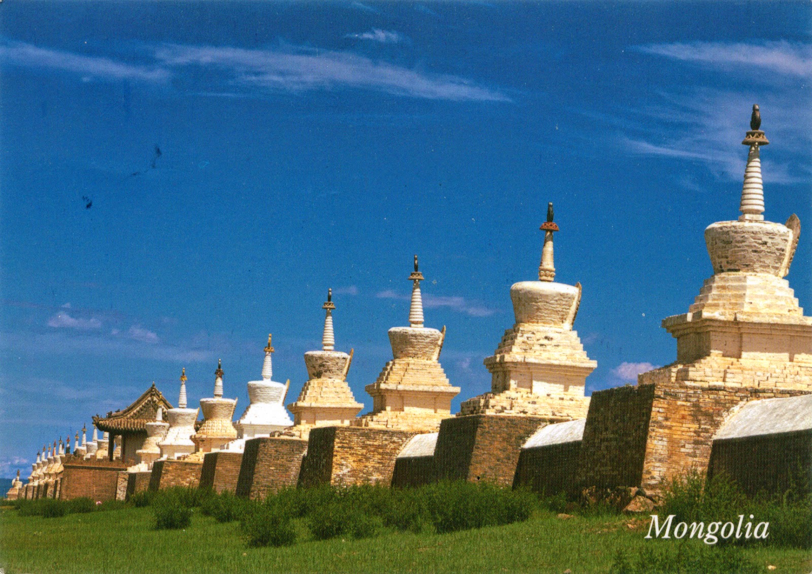
For many centuries, the Orkhon Valley, located in Central Mongolia, some 320 km west from the capital Ulan Bator, was viewed as the seat of the imperial power of the steppes. The first evidence comes from a stone stele with runic inscriptions, which was erected in the valley by Bilge Khan, an 8th-century ruler of the Göktürk Empire. Some 25 miles to the north of the stele, in the shadow of the sacred forest-mountain Ötüken, was his Ördü, or nomadic capital. Mountains were considered sacred in Tengriism, but Ötüken was especially sacred, because the ancestor spirits of the khagans and beys resided here. Whoever controlled this valley was considered heavenly appointed leader of the Turks and could rally the tribes. Thus control of the Orkhon Valley was of the utmost strategic importance for every Turkic state.

Read more »

1111 ROMANIA - The map and the flag of the country

$
0
0

Located on the Lower Danube, at the north of the Balkan Peninsula (in which it is often framed, because of the historical and cultural similarities), on the western shore of the Black Sea, between Bulgaria, Hungary, Serbia and Ukraine, and having a border (which wouldn't have to exist) with Moldova, Romania forms a complex geographic unit centred on the Transylvanian Basin, around which the peaks of the Carpathian Mountains form a crescents. Beyond this zone, the plains of the south and east of the country, their potential increased by the Danube River and its tributaries, form a fertile outer crescent extending to the frontiers. Romania comprises a number of geographic regions, corresponding, completely or partially, to the historic regions whose names they share: Wallachia (consisting of Muntenia and Oltenia), Moldavia (only western Moldavia - the Hertza region is today in Ukraine, and eastern Moldavia, or Bessarabia, is divided between Moldova and Ukraine), Bukovina (only southern Bucovina - the north is today in Ukraine), Dobruja (only the north - the south of Dobruja, or Cadrilater, is today in Bulgaria), Transylvania, Banat (shared with Serbia and Hungary), Crișana (shared with Hungary), and Maramureș (only the south - the northern part is currently in Ukraine).

Read more »

1112 UNITED KINGDOM (Scotland) - A Highlander piper near the Eilean Donan Castle

$
0
0

For centuries the inhabitants of Scotland have been building fortifications and strongholds of one kind or another, so that at one time there were over 3,000 castles, larger or smaller. Many of them are in ruins or have disappeared completely, but hundreds still remained, to remind the tumultuous history of these lands. One of the most picturesque of them is the castle located on the Eilean Donan (Island of Donnán), a small tidal island where three lochs meet, Loch Duich, Loch Long and Loch Alsh, in Wester Ross. It is possible that an early Christian monastic cell was founded on the island in the 6th or 7th century, dedicated to Donnán of Eigg, an Irish saint who was martyred on Eigg in April 617. Anyway, the name of the island comes from this saint.

Read more »

1113 MICRONESIA (Pohnpei) - Pohnpei Surfing

$
0
0

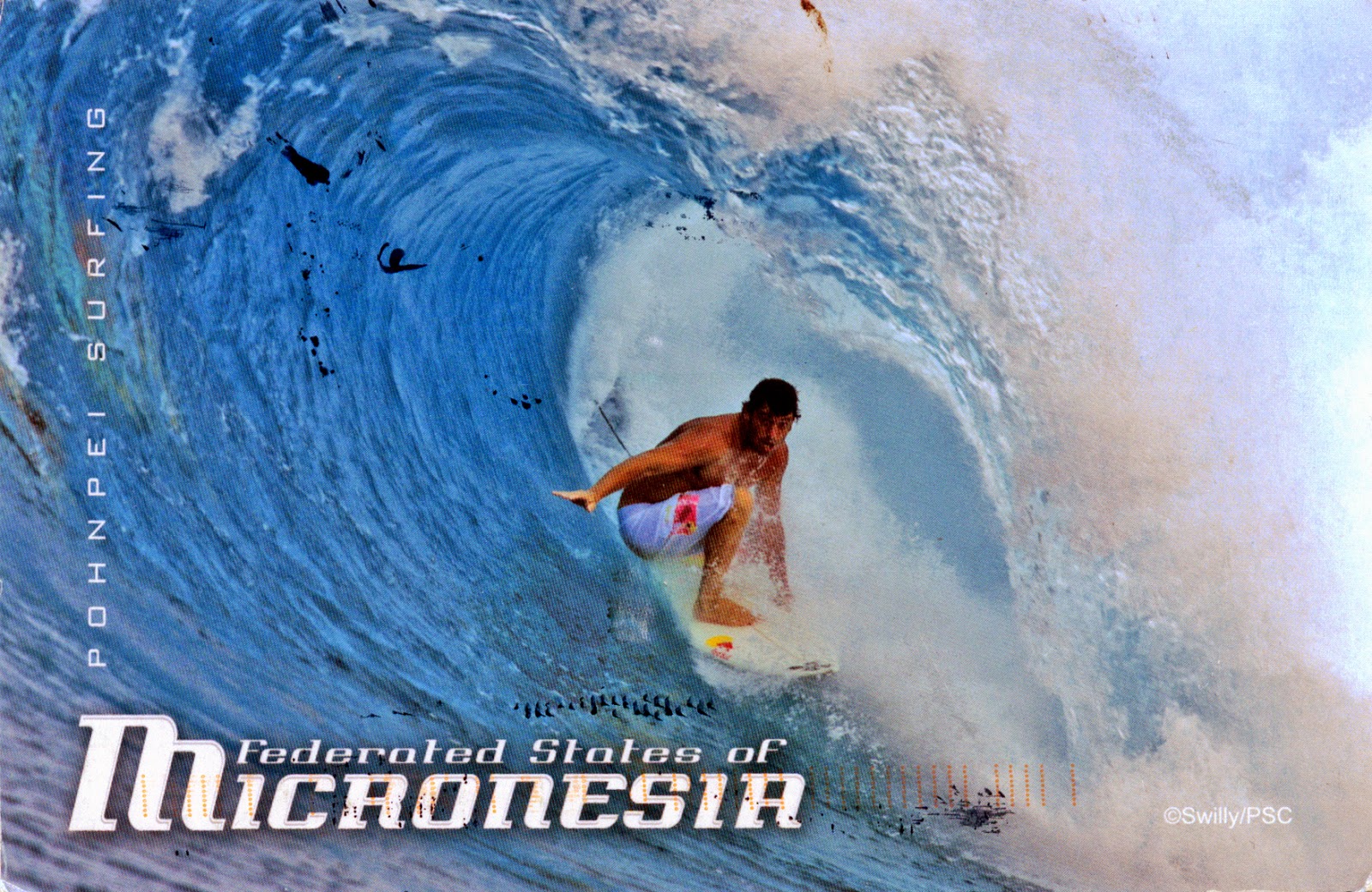
Pohnpei"upon (pohn) a stone altar (pei)" (formerly known as Ponape) is an island of the Senyavin Islands, which are part of the larger Caroline Islands group. It belongs to Pohnpei State, one of the four states in the Federated States of Micronesia (FSM). Palikir, the FSM's capital, is located on Pohnpei Island, the largest, highest, most populous, and most developed single island in the FSM. The locals have a reputation as being the most welcoming of outsiders among residents of the island group. Pohnpei is one of the wettest places on earth, and contains a wealth of biodiversity.

Read more »
1114 INDIA (Goa) - Churches and Convents of Goa - The Tower of the Church of St. Augustine (UNESCO WHS)

$
0
0

Situated at approximately 10km east of Panjim, Old Goa (Velha Goa) is a historical city,  founded in the 15th century on the banks of the Mandovi river by the rulers of the Bijapur Sultanate, to replace Govapuri, used as a port by the Kadamba and Vijayanagar kings. It served as capital of Portuguese India from the 16th century until its abandonment in the 18th century due to a plague. It is said to have once been a city of nearly 200,000 where from, before the plague, the Portuguese traded across continents. As center of Christianisation in the East, the city was evangelised by all religious orders, since all of them had their headquarters there. It was incorporated into the Republic of India in 1961, together with the rest of Goa.

Read more »

1115, 1116 RUSSIA (Arkhangelsk Oblast) - Cultural and Historic Ensemble of the Solovetsky Islands (UNESCO WHS)

$
0
0

The Solovetsky Islands (or Solovki) are a group of six islands located in the Onega Bay of the White Sea, with a population of only 861 inhabitants. They have been the setting of the Russian Orthodox Solovetsky Monastery complex, founded in the second quarter of the 15th century by two monks from the Kirillo-Belozersky Monastery. The existing stronghold and its major churches were erected in stone during the early reign of Ivan the Terrible at the behest of St. Philip of Moscow. By the end of the 16th century, the abbey had emerged as one of the wealthiest landowners and most influential religious centres in Russia. At the onset of the Schism of the Russian Church, the monks staunchly stuck to the faith of their fathers and expelled the tsar's representatives from the Solovki, precipitating the eight-year-long siege of the islands by the forces of Tsar Alexis. The Solovetsky complex was included between UNESCO World Heritage Sites in 1992, as an outstanding example of a monastic settlement in the inhospitable environment of northern Europe, which admirably illustrates the faith, tenacity and enterprise of late medieval religious communities. On the other hand, unfortunatelly it was turned into a special Soviet prison and labor camp (1926–1939), which served as a prototype for the Gulag system.


The architectural ensemble of the Solovetsky Monastery is located on the shores of the Prosperity Bay on Solovetsky Island, and is surrounded by massive walls (height 8 to 11 m, thickness 4 to 6 m) with 7 gates and 8 towers (built in 1584-1594 by an architect named Trifon), made mainly of huge boulders up to 5 m in length. The heart of the complex is the monastery itself, in three parts: the central square with its complex of monumental buildings, and the northern and southern courtyards devoted to domestic and craft activities. The central square is flanked by the Church of the Assumption, in Novgorod style with its refectory and cellarage, the Saviour Transfiguration Cathedral, the Bell Tower (1776-77), the Church of St Nicholas (1831-33), and the Holy Trinity, Zosimus and Sabbath Cathedral (1859). The north courtyard complex includes high-quality craft buildings, including the icon workshop (1615), the tailors' and cobblers' workshops (1642), storerooms, the Father Superior's lodgings, and a 17th-century leather-dressing cellar. In the south courtyard area are a drying barn, a mill, a wash-house and a bath-house.

Read more »

1014, 1117 FINLAND - Sami people in traditional clothes

$
0
0

Posted on 25.02.2014, 26.06.2014
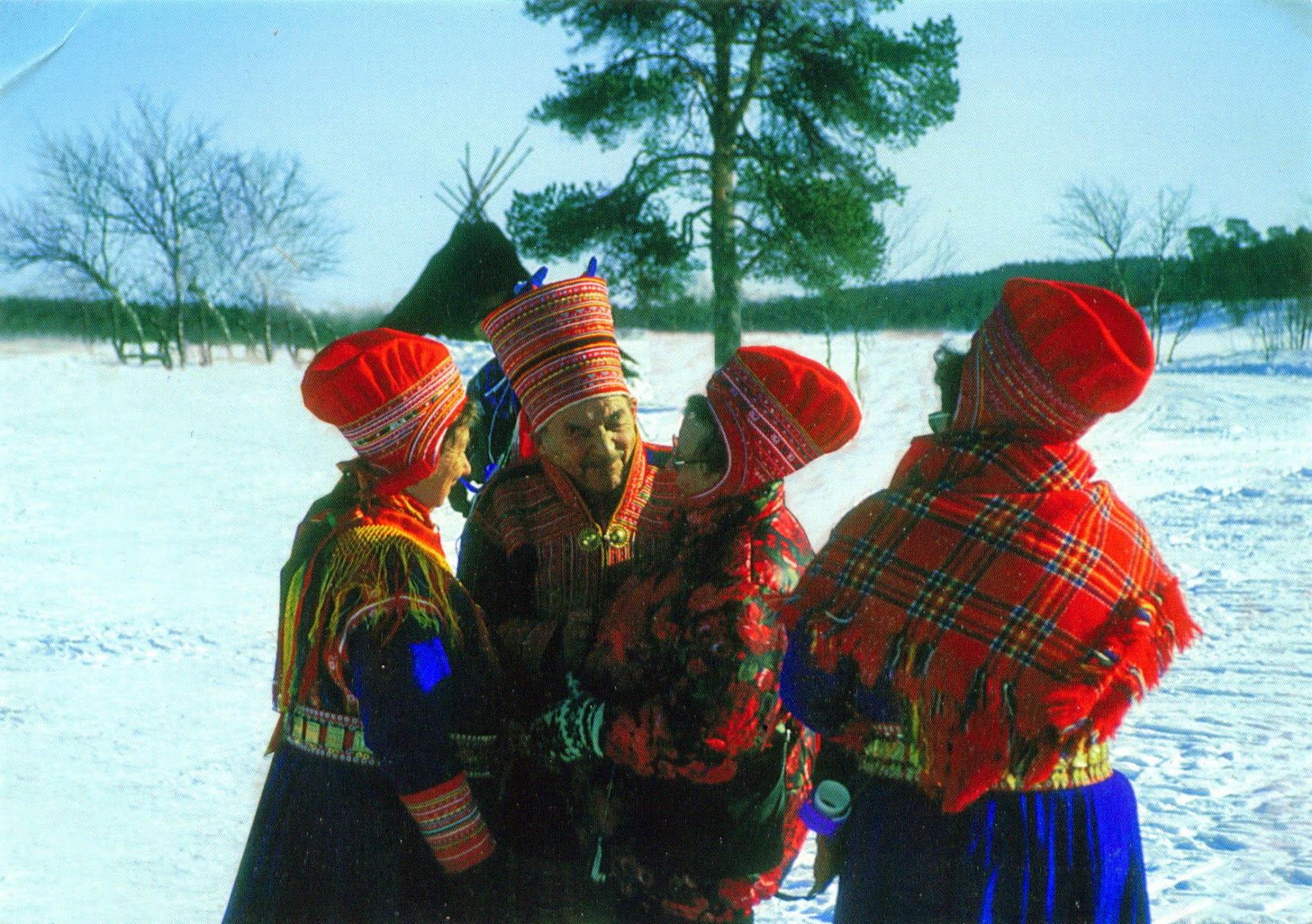
The Sami people are the indigenous Finno-Ugric people inhabiting the Sápmi, the cultural region which today encompasses parts of far northern Norway, Sweden, Finland, the Kola Peninsula of Russia, and the border area between south and middle Sweden and Norway. Known also as Lapps, an exonym considered by them as pejorative, the Sami have pursued a variety of livelihoods (including coastal fishing, fur trapping, and sheep herding), but the most representative is the semi-nomadic reindeer herding. Although they lived in Arctic Europe since prehistoric times (being mentioned for the first time in about 98 CE), they have been for centuries the subject of discrimination and abuse by the dominant cultures, being recognized as an indigenous people only in the last part of the 20th century in Norway, Sweden and Finland, and in Russia not even today.


From the approximately 160,000 Sami (although the sources are highly conflicting, some indicating a population of just 80,000) only slightly more than 7000 are living in Finland. Called gákti or kolt, their traditional costume is worn both in ceremonial contexts and while working. Traditionally, it was made from reindeer leather and sinews, but nowadays it is more common to use wool, cotton, or silk. It differ from community to community, and the colours, patterns and the jewellery have deeper meaning. There are also different gákti for women and men (for men a shorter "jacket-skirt", for women a long dress). Traditional gákti are most commonly in variations of red, blue, green, white, medium-brown tanned leather, or reindeer fur. In winter, there is the addition of a reindeer fur coat and leggings, and sometimes a poncho (luhkka) and rope/lasso. The collar, sleeves and hem usually have appliqués in the form of geometric shapes.

Read more »

1118 BARBADOS - A traditional chattel house

$
0
0

In 1625 Barbados was claimed by England, and the first settlement in the island was founded in 1627 by Henry Powell, who arrived with 80 settlers and 10 slaves (kidnapped or runaway English or Irish youth). In 1640 was introduced the sugarcane from Dutch Brazil, and this completely transformed the society and the economy, Barbados becoming one of the world's biggest sugar industries (in 1660 it generated more trade than all the other English colonies combined). As the cost of white labour rose in England, more slaves were imported from West Africa, so if in the mid 1600's there was over 5600 black African slaves on island, by early 1800's figure reached 385,000, in the 1700's Barbados being one of the leaders in the slave trade from the European colonies.

Read more »

1119 FRANCE (Languedoc-Roussillon) - Historic Fortified City of Carcassonne (UNESCO WHS)

$
0
0

Situated in the Aude plain between two great axis of circulation linking the Atlantic to the Mediterranean sea and the Massif Central to the Pyrénées, Carcassonne has about 2,500 years of history and is famous for its medieval fortress, located on a hill on the right bank of the River Aude, and restored by the theorist and architect Eugène Viollet-le-Duc in 1853 and added to the UNESCO list of World Heritage Sites in 1997. At the beginning of its history it was a Gaulish settlement then in the 3rd century A.D., the Romans decided to transform it into a fortified town. The main part of the lower courses of the northern ramparts dates from these times. Visigoths had occupied Carcassonne in 453, and built more fortifications. In 725 Saracens from Barcelona took the citadel, but King Pepin the Short drove them away in 759-60.

Read more »

0652, 0653, 1120 ITALY (Tuscany) - Historic centre of Florence (UNESCO WHS)

$
0
0

Posted on 21.05.2013, 27.06.2014
Founded by Romans as a settlement for veteran soldiers and named Fluentia, because it was built between two rivers, then successively ruled by Ostrogoths, Byzantines, and Lombards, Florence was conquered by Charlemagne in 774, but it surpassed the status of minor settlement only around 1000 A.D., after Margrave Hugo chose it as residency. From the 14th century to the 16th century, it was, according to the Encyclopædia Britannica, one of the most important cities in Europe and the world, of political, economic and cultural point of view. Wealthy and brilliant, but with a turbulent history, furrowed by numerous religious and republican revolutions, Florence is considered the birthplace of the Renaissance. It was home for the famous Medici family and Savonarola, but also for Michelangelo, Leonardo da Vinci, Botticelli, Giotto, Boccaccio, Dante, Machiavelli, Galileo Galilei and many others.


Because Historic Centre of Florence"attests in an exceptional manner, and by its unique coherence, to its power as a merchant-city of the Middle Ages and the Renaissance", in 1982 it became an UNESCO World Heritage Site. In the first postcard can be seen:
Ponte Vecchio (Old Bridge) - a Medieval stone closed-spandrel segmental arch bridge over the Arno River, noted for still having shops built along it.
A general view of Historic Centre.
Basilica di Santa Maria del Fiore (Basilica of Saint Mary of the Flower), Battistero di San Giovanni (Baptistry of St. John) and, in back, Campanile di Giotto (Giotto’s Campanile).
Basilica di Santa Croce (Basilica of the Holy Cross) - the principal Franciscan church in Florence, the burial place of Michelangelo, Galileo, Machiavelli, Foscolo, Gentile and Rossini.
Palazzo Vecchio (Old Palace) - the town hall of the city, built in the 13th century.
Basilica of Santa Maria Novella - the first great basilica in Florence, and the city's principal Dominican church. Especially famous are frescoes by masters of Gothic and early Renaissance.
San Miniato al Monte (St. Minias on the Mountain) and the Bishop's Palace - placed on one of the highest points in the city, it has been described as one of the finest Romanesque structures in Tuscany and one of the most beautiful churches in Italy.


At the foreground of the third postcard are the Baptistery and Giotto's Campanile, seen from Piazza del Duomo (Cathedral Square), located in the heart of the historic center, and in the background can be seen the facade and dome of the Florence Cathedral. Erected between 1059 and 1128 in Florentine Romanesque style,  the Baptistery has eight equal sides with a rectangular addition on the west side, all clad in geometrically patterned colored marble. The pilasters on each corner are decorated with white and dark green marble in a zebra-like pattern. Dante and many other notable Renaissance figures were baptized here. Giotto’s Campanile (built between 1334 and 1359) is a free-standing campanile with five levels (84.7m height), one of the showpieces of the Florentine Gothic architecture with its design by Giotto, its rich sculptural decorations and the polychrome marble encrustations.

Read more »

1121 SURINAME - A surinamese woman in amerindian cultural clothing

$
0
0

According to the 2012 census, only 3.7% of the population of Suriname are of indigenous ancestry, whitch means about 20,000 people. The main ethnic groups of original inhabitants can be devided into the lowland and upland ones. The lowland Amerindians are the Arawaken and the Caraiben, whilst there are three groups of Amerindians who can be considered as the upland ones namely, the Wajanas, the Trioes and the Akurioe, who live mainly in the South-Eastern portion of the country. Very few of them still leading a traditional way of life, mostly being influenced by western culture. I think that the woman from the postcard wears an outfit that only suggests the traditional one.

Read more »

1122 PERU (Puno) - Lake Titicaca (UNESCO WHS - Tentative List) and its floating islands

$
0
0

Located in the Andes, on the border of Peru and Bolivia, Titicaca (Titiqaqa in Quechua) covers 8,300 square km and is the largest lake in South America, and also the highest navigable lake in the world, with a surface elevation of 3,812m. Its waters are limpid and only slightly brackish, and the surface temperatures average is 14°C. The lake averages between 140 and 180m in depth, reaching its greatest recorded depth of 280 m off Isla Soto in the lake's northeast corner. It holds large populations of water birds and was designated as a Ramsar Site on August 26, 1998. Several threatened species are largely or entirely restricted to the lake. In addition, approximately 90% of the fish species in the basin are endemic.

Read more »

1059, 1123 NEPAL - Faces of Nepal

$
0
0

Posted on 14.04.2014, 29.06.2014
Nepali society is multiethnic and multilingual, Nepalese people (or Nepali or Gurkha) being the descendants of three major migrations from India, Tibet, and North Burma and the Chinese province of Yunnan via Assam. Even though Indo-Nepalese migrants were latecomers to Nepal relative to the migrants from the north, they have come to dominate the country not only numerically, but also socially, politically, and economically. Nepal's 2001 census enumerated 102 castes and ethnic groups. There are three main ethnicities: Khas (Bahun, Chhetri, Damai, Kami etc.), Mongoloid (Tamang, Gurung, Magar, Sherpa, Thakali and Kirat) and mixed (Newar). Nepali, a derivative of Sanskrit, is the official language; Newari, a language of the Tibeto-Burman family, and numerous other languages are spoken. About 90% of the population is Hindu, and the remaining Buddhist.


Read more »

1124 TURKEY (Aegean Region) - Miletus

$
0
0

Situated on the western coast of Asia Minor, near the mouth of the Maeander River (from which come the word "meander") in ancient Caria, Miletus was considered the greatest and wealthiest of Greek cities before the Persian invasion in the middle of the 6th century BC. After a period of decline, it reached its greatest wealth and splendor during the Hellenistic era (323-30 BC) and later Roman times. It became known for the great number of colonies founded around the Black Sea, more than any other Greek city (90), but also for the annual pilgrimage along the Sacred Way that led from Miletus to the Temple of Apollo at Didyma, a distance of 20 km (build under the Emperor Trajan, in 2nd century AD), and as the birthplace of philosopher Thales, and of Isidore, the Hagia Sophia's architect. By the 6th century, the silting of the Meander River had destroyed the city's harbors and attracted malaria. By the Ottoman period, the once-proud city was just a small village. The site was finally abandoned in the 17th century. Today the ruins of city lie some 10km from the sea.

Read more »

1125 UNITED STATES (Utah) - The map and flag of State of Utah

$
0
0

Bordered by Colorado, Wyoming, Idaho, Arizona and Nevada (and touching a corner of New Mexico), Utah, one of the Four Corners states, is well known as the most religiously homogeneous state in the Union (its nickname is Beehive State), approximately 62% of Utahns being members of The Church of Jesus Christ of Latter-day Saints or LDS (Mormons), which greatly influences the state's culture and daily life. The world headquarters of The Church of Jesus Christ of Latter-day Saints (LDS Church) is located in the state capital, Salt Lake City, founded in 1847 in proximity to the Great Salt Lake. It is a geographically diverse state, located at the convergence of three distinct geological regions: the Rocky Mountains, the Great Basin, and the Colorado Plateau. Utah is known for its natural diversity and is home to features ranging from arid deserts with sand dunes to thriving pine forests in mountain valleys.

Read more »

1127 FIJI - Natadola Beach

$
0
0

Located in the South Pacific Ocean, at about 2,000 km northeast of New Zealand's North Island, and comprising 332 islands and 522 islets, Fiji is endowed with forest, mineral, and fish resources, being a developing country with a large subsistence agriculture sector. Tourism has expanded rapidly since the early 1980s and is the leading economic activity in the islands. The largest island and also the site of the nation's capital, Suva, is Viti Levu, home to 70% of the population (about 600,000) and the hub of the entire Fijian archipelago. Its size is comparable with The Big Island of Hawaii or slightly smaller than Connecticut.

Read more »
Viewing all 2426 articles
Browse latest View live