Quantcast
Channel: WORLD, COME TO MY HOME!
Viewing all 2426 articles
Browse latest View live

1128 GREECE (South Aegean) - The traditional architecture of Oia, in Santorini

$
0
0

Located in the southern Aegean Sea, about 200km southeast of Greece's mainland, Santorini, classically Thera, and officially Thira, is the largest island of a small, circular archipelago which bears the same name. It is essentially what remained after an enormous volcanic eruption (which occurred some 3600 years ago) that destroyed the earliest settlements on a formerly single island, and may have led indirectly to the collapse of the Minoan civilization on the island of Crete, 110km to the south, through a gigantic tsunami. A giant central, rectangular lagoon, which measures about 12 by 7km, is surrounded by 300m high, steep cliffs on three sides.

Read more »

0379, 1129 CROATIA (Dubrovnik-Neretva) - Old City of Dubrovnik (UNESCO WHS)

$
0
0

Posted on 09.11.2012, 07.07.2014
Located in the southern Dalmatian coast, Dubrovnik, named official Ragusa until 1918,  and known as Pearl of the Adriatic or even Thesaurum mundi,  "is a remarkably well-preserved example of a late-medieval walled city, with a regular street layout", reason for which it was designated by UNESCO a World Heritage Site in 1979 (with an extension in 1994), under the name Old City of Dubrovnik. Until recently, it was believed that the city was founded about 614 AD by a group of refugees from Epidaurum (today's Cavtat), who fled of the Slavs and Avars and established a settlement to an island, and named it Laus (lausa means rock in latin), which will become Ragusa or Rausa. Opposite that location, at the foot of Srđ Mountain, the Slavs developed their own settlement, under the name of Dubrovnik (from dubrava, which means oak woods). In the 12th century the channel that separated these two settlements was filled (in present is Placa or Stradun, the main street of the city) and they were united. But recent archaeological discoveries have pushed the city's history before the Common Era, there being evidence that Dubrovnik was established by Greek sailors.


Being first under the protection of the Byzantine Empire, Ragusa came, after the infamous Fourth Crusade, under the sovereignty of Venice (1205-1358), then by the Treaty of Zadar (1358) became part of the Hungarian-Croatian Kingdom, and since 1458 paid a tribute to the Ottoman Empire, but was effectively a free state between 1358 and 1808, named Respublica Ragusina (Ragusan Republic). Its motto, Non bene pro toto libertas venditur auro (Latin for "Liberty is not well sold for all the gold"), says everything about its principles, as also the fact that the republic abolished the slave trade early in the 15th century, and its official language was Latin until 1472, and thereafter the Ragusan dialect of the Romance Dalmatian language.

Read more »

1130 INDIA (Rajasthan) - A Rajasthani woman in traditional dress

$
0
0

Located on the western side of India, at the border with Pakistan, between Gujarat, Madhya Pradesh, Uttar Pradesh, Haryana, and Punjab, and comprising most of the wide and inhospitable Thar Desert, Rajasthan ("Land of Kings" or "Land of Kingdoms") is India's largest state by area. It has a mainly Rajasthani population of approximately 68,621,012, made up mainly of Hindus, who account for 88.8% of the population. Although history of Rajasthan goes back as far as Indus Valley Civilization, the foundation of Rajasthani community took shape with the rise of Western Middle Kingdoms such as Western Kshatrapas (35-405 BC). They were successors to the Indo-Scythians who invaded the area of Ujjain and established the Saka era, marking the beginning of the long-lived Saka Western Satraps kingdom. With time their social structures got stronger reorganizations giving birth to several martial sub ethnic groups. Some claim that Romani people originated in parts of the Rajasthan and Gujarat. Indian origin was suggested on linguistic grounds as early as 200 years ago. The roma ultimately derives from a form ḍōmba ("man living by singing and music"), attested in Classical Sanskrit.

Read more »

1131 NETHERLANDS (North Holland) - An orange Amsterdam

$
0
0

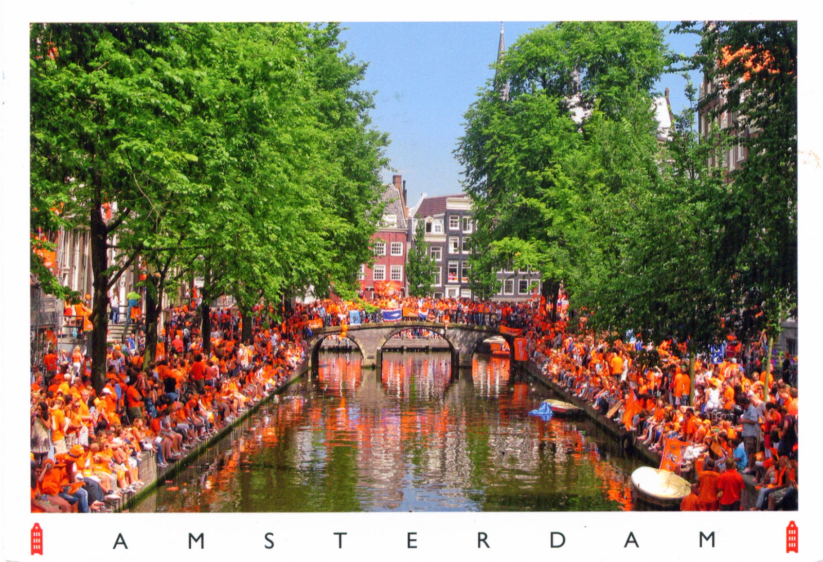
I searched long time on the Internet this postcard, but I couldn't find it, so I don't know why gathered all these people on this canal in Amsterdam. Anyway, it must be something with national spirit, because so many wears orange shirts. For those who don't know, orange is the color of the Dutch Royal Family, but today it symbolizes a broader pride in the country and in being Dutch. The lineage of the current dynasty - the House of Oranje-Nassau - dates back to Willem van Oranje (William of Orange). It is possible that the photograph to have been done with the ocasion of Koningsdag (King's Day), celebrated on 27 April (26 April if the 27th falls on a Sunday) to mark the birth of King Willem-Alexander. This day is an opportunity for "orange madness" or oranjegekte, for the national colour, when the normally strait-laced Dutch let down their hair, often dyed orange for the occasion.

Read more »

1133 SPAIN (Balearic Islands) - The traditional Ibiza women dress

$
0
0

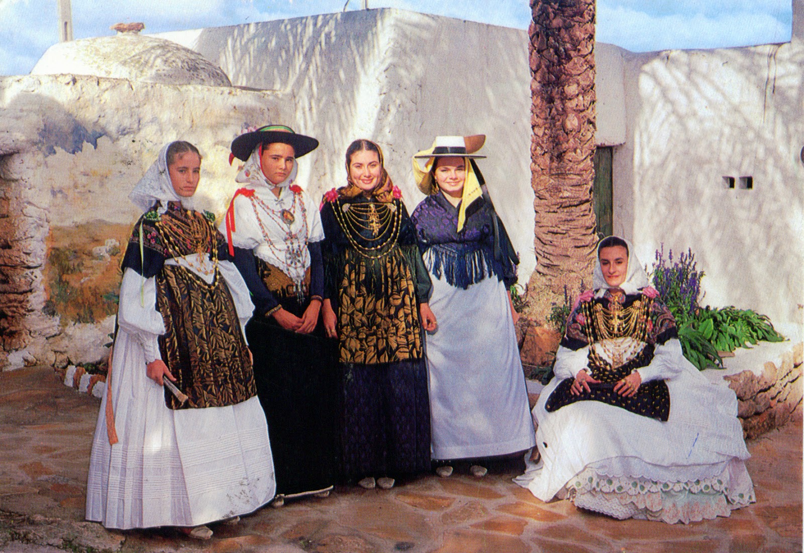
Placed at 79km off the coast of the city of Valencia, Ibiza (Catalan: Eivissa), the third largest of the Balearic Islands, is well known in our days for its summer club scene which attracts very large numbers of tourists. Colonized by Phoenicians in 654 BC, then ruled successively by Carthaginians, Romans, Vandals, Byzantines, Moors, Norwegians, and Aragoneses, became part of Spain, maintaining its own self-government in several forms until 1715, when King Philip V of Spain abolished the local government's autonomy. At the geographical heart of the island, the village of Santa Gertrudis is Ibiza in microcosm. Steeped in tradition, its main square houses the whitewashed church and a cluster of bars, restaurants and shops, whilst in the rich agricultural landscape all around, live sheep, goats and the island's only dairy cows. The architecture is sober and simple, and the folklore remained on the same line, perhaps with some colorful touches.

Read more »

1030, 1134 ITALY (Tuscany) - Historic Centre of Siena (UNESCO WHS)

$
0
0

Posted on 12.03.2014, 09.07.2014
Settled for the first time by Etruscans (c. 900-400 BC), Siena was founded, according to legend, by Senius, son of Remus. Anyway, it didn't prospered under Roman rule, because it wasn't sited near any major roads. After the Lombard occupation, the situation was changed, and the city developed as a trading post. Conquered by Charlemagne in 774, the city became republic in 12th century, which existed for over 400 years. In the Italian War of 1551-1559, the republic was defeated by the rival Duchy of Florence in alliance with the Spanish crown, and that ceded it to the Grand Duchy of Tuscany, to which it belonged until the unification of Italy in the 19th century. In 1995, its historic centre was designated a UNESCO World Heritage Site, because "the whole city of Siena, built around the Piazza del Campo, was devised as a work of art that blends into the surrounding landscape."


The Siena Cathedral, dedicated on its earliest days as a Roman Catholic Marian church, and now dedicated to Santa Maria Assunta (Holy Mary, Our Lady of the Assumption), begun in the 12th century, and is one of the great examples of Italian Romanesque-Gothic architecture. Its main façade was completed in 1380. After the completion of the transept and the building of the east wall the money ran out and the rest of the cathedral was abandoned. In the interior the pictorial effect of the black and white marble stripes on the walls and columns strikes the eye. Black and white are the colours of the civic coat of arms of Siena. The capitals of the columns in the west bays of the nave are sculpted with allegorical busts and animals. The horizontal moulding around the nave and the presbytery contains 172 plaster busts of popes dating from the 15th and 16th centuries starting with St. Peter and ending with Lucius III. The spandrels of the round arches below this cornice exhibit the busts of 36 emperors.

Read more »

1019, 1135 UNITED STATES (New York) - The map of State of New York

$
0
0

Posted on 02.03.2014, 09.07.2014
Bordered by New Jersey and Pennsylvania to the south and by Connecticut, Massachusetts, and Vermont to the east, New York State has a maritime border with Rhode Island, as well as an international border with Canada. It is a center for finance and culture, and also the largest gateway for immigration to the United States. Over 100 million Americans can trace their ancestry to the immigrants who first arrived in America through Castle Clinton and Ellis Island. New York City, with a population of over 8.3 million in 2012, is the most populous city in the U.S.A., making up over 40% of the population of the state. Both the state and city were named for the 17th century Duke of York, future King James II of England. Its capital city is Albany, officially chartered as a city in 1686 and located on the west bank of the Hudson River, about 16km south of its confluence with the Mohawk River.


New York was inhabited by various tribes of Algonquian and Iroquoian at the time when Dutch settlers moved into the region in the early 17th century. In 1609, the region was first claimed by Henry Hudson for the Dutch, and Fort Nassau was built near the site of the present-day capital of Albany in 1614. The Dutch soon also settled New Amsterdam and parts of the Hudson River Valley, establishing the colony of New Netherland. The English captured the colony during the Second Anglo-Dutch War and governed it as the Province of New York, of which borders were similar to those of the present-day state. About one third of all the battles of the Revolutionary War took place in New York, which became the 11th state to ratify the U.S. Constitution.

Read more »

0733, 0734, 1136 CROATIA (Split-Dalmatia) - Historical Complex of Split with the Palace of Diocletian (UNESCO WHS)

$
0
0

Posted on 11.07.2013, 09.07.2014
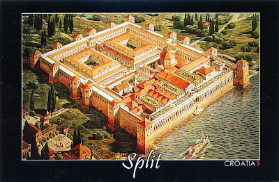
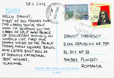
It is said that the Diocletian's Palace is placed on the center of the city of Split. For the sake of accuracy, I must say that in fact the city was built around the palace. It was began in 293 AD, and was finished in 305, right on time to receive its owner, who retired there, becoming the first Roman Emperor to voluntarily remove himself from office. He will enjoy only 6 years by the pleasures offered by the opulent refuge, because he committed suicide in 311. After the Romans abandoned the site, the palace remained empty until the 7th century, when nearby residents fled to the walled palace to escape invading barbarians, and so was born the current city. After the Middle Ages the palace was unknown in the West until the Scottish neo-classical architect Robert Adam discovered the ruins in 18th century. In 1979 UNESCO designated the Historical Complex of Split with the Palace of Diocletian an World Heritage Site.


As can be seen in the first postcard, a reconstruction of the palace in its original appearance, made by the French architect and archaeologist Ernest Hébrard in 1912, the ground plan of the assembly is an irregular rectangle (approximately 160m x 190m), with towers on three sides. The palace is enclosed by walls, and at times, it housed over 9000 people. Only the southern facade, the one seaward, was unfortified. The palace combines therefore the qualities of a luxurious villa with those of a military camp. A monumental gate in the middle of each of the walls led to an enclosed courtyard. The southern sea gate (the Porta Aenea) was simpler in shape and dimensions than the other three. The transverse road (decumanus) linking the eastern gate (the Silver Gate or Porta Argentea) and western gate (the Iron Gate or Porta Ferrea) divided the complex into two-halves.


A monumental court, called the Peristyle, formed the northern access to the imperial apartments. It also gave access to Diocletian's mausoleum on the east (now Cathedral of St. Domnius), and to three temples on the west (two of which are now lost, the third having become a baptistery, originally being the temple of Jupiter). The northern half of the palace, divided in two parts by the main north-south street (cardo) leading from the Golden Gate (Porta Aurea) to the Peristyle, is less well preserved. The palace was built of white local limestone, marble of high quality, tuff and brick, and was decorated with numerous 3500 year old granite sphinxes, originating from the site of Egyptian Pharaoh Thutmose III. Only three have survived the centuries. In the left is the Bell Tower, constructed in the year 1100 AD, in the Romanesque style, the city's main symbol.

Read more »

1137 GRENADA - The carnival in Island of Spice

$
0
0

Located in the southeastern Caribbean Sea, and known as the Island of Spice, Grenada, a former colony of Britain and France, was built on the labour of enslaved Africans, so the vast majority of the population are of African descent (about 90%), and its culture is a combination of French and African cultures. For Christians, Carnival is a festive season which occurs immediately before Lent (the word "carnival" comes from the Latin carne levare - farewell to meat). In colonies, the slaves were left out of their owners' fun and fanfare, so they organized their own parties, puting together costumes with what little they had. Grenada's Carnival (Spice Mas) has been celebrated on the island since the Europeans occupied it, each year before Lent, but because since 1975 in february is also celebrated the independence, it was moved several times, until it came to be celebrated in August (for 2014 it starts on the 10th of August and ends on the 14th). After months of preparation, there are many events to attend at the National Stadium: the National Queen show, the SMC/LIME Soca Monarch Competition, the Panorama Night of Pan and Soca. The pre-Carnival festivities culminates with Dimanche Gras. After four days of music and competition, the party is ready to get started with the three main events of Spice Mas.

Read more »

1138 FAROE ISLANDS - Kamarið Cliff in Suðuroy

$
0
0

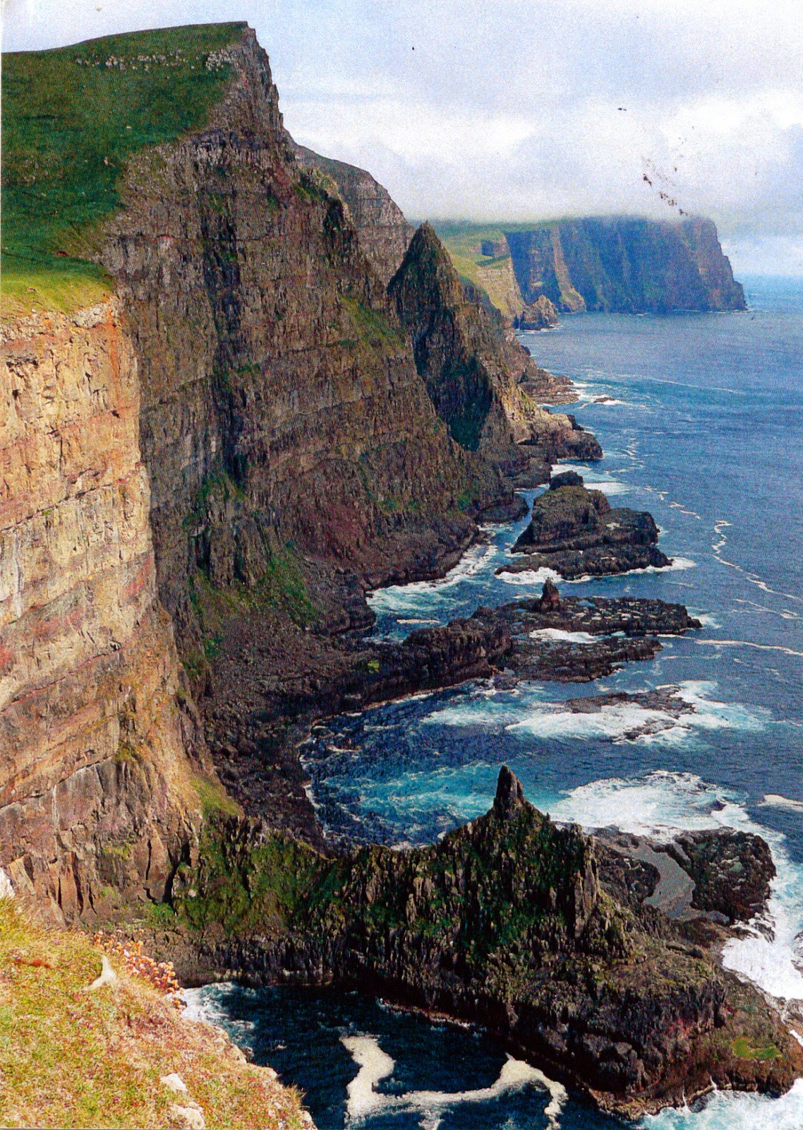
Covering 163.7 square kilometres and being inhabited by 4,678 people, Suðuroy (literally South Island) is the southernmost of the Faroe Islands. It is the island which has the most islets and skerries (263), and also the only of the 18 islands of the Faroes which has a coalmine still active. The highest point of Suðuroy is the mountain Gluggarnir (610m), but the most famous peak is definitely the mountain of Beinisvørð north-west of the village of Sumba. The Beinisvørð and its scenery have been praised by the local poet Poul F. Joensen (1898–1970), as well as other Faroese poets. The western side of the island has been identified as an Important Bird Area by BirdLife International because of its significance as a breeding site for seabirds, especially Northern Fulmars, European Storm Petrels, European Shags, Black-legged Kittiwakes, Atlantic Puffins, Common Guillemots and Black Guillemots. On the postcard is Kamarið (The Chamber), near the village Vágur, situated on the east coast of the island on the Vágsfjørður fjord.

Read more »

0432, 1139 JORDAN - Wadi Rum Protected Area (UNESCO WHS)

$
0
0

Posted on 26.12.2012, 10.07.2014
Placed between Saudi Arabia, Iraq, Syria and Israel, sharing control of the Dead Sea with the latter two, and its only port, at the Gulf of Aqaba, with Israel, Egypt, and Saudi Arabia, Jordan consists of an arid plateau in the east and an highland area in the west, with arable land and Mediterranean evergreen forestry, part of the region considered to be "the cradle of civilization", the Levant region of the Fertile Crescent. Controlled by the ancient empires of Persians and Macedonian Greeks, and later by the Nabatean kingdom and Roman Empire, it became a heartland for the Arabic Islamic Empire, and in 1516 was incorporated in the Ottoman Empire. During WWI, the Transjordanian tribes fought against the Ottoman Empire as part of the Arab Army of the Great Arab Revolt, supported by the Allies. The chronicle of the revolt was written by T. E. Lawrence (in the picture, on the first postcard) who, as a young British Army officer, played a liaison role during the revolt, and become the basis for the iconic movie Lawrence of Arabia. In 1922 Transjordan came under the British Mandate, which ended in 1946.


Located at 60km to the east of Aqaba, Wadi Rum (transcribed by archaeologists as Wadi Ramm), also known as The Valley of the Moon, is the largest wadi (a dry riverbed, that contains water only during times of heavy rain) in Jordan, cut into the sandstone and granite rock. Due to its iconic desert landscape, renowned for its spectacular series of sandstone mountains and valleys, natural arches, and the range of narrow gorges, towering cliffs, massive landslides, and dramatic cavernous weathering forms displayed, but also due to the evidence of long-term patterns of pastoral, agricultural and urban human activity (25,000 petroglyphs, 20,000 inscriptions, and 154 archaeological sites, stretched over a period of at least 12,000 years), Wadi Rum Protected Area became an UNESCO World Heritage Site in 2011. In the West, Wadi Rum is best known for its connection with T. E. Lawrence, who based his operations here during the Arab Revolt of 1917-1918, so in the 1980s one of the rock formations in this wadi (in the picture) was named The Seven Pillars of Wisdom, after Lawrence's bookwith the same name.

Read more »
1140 KAZAKHSTAN - Mosque Khazret Sultan in Astana

$
0
0

In 1997, Nursultan Nazarbayev, the Kazakhstan's leader since 1989, but found in the circles of power long before the separation of the country from Soviet Union, moved the capital from Almaty in the southeast, in the north, to the steppe town of Akmola, to which changed also the name in Astana. On 6 july 2012, to commemorate the 14th anniversary of this event, was opened in the city the biggest mosque not only in Kazakhstan, but even in the whole Central Asia. Kazakhstan is the largest economy in Central Asia, and is predominantly Muslim (followers of the Hanafi school of Sunni Islam), so nothing strange this far, but was it a coincidence that July 6th was also Nazarbaev's 72nd birthday? The mosque, called Khazret Sultan, is big enough to take 5,000 worshippers and stands on a 27 acre site, roughly the size of 18 football pitches. Each of its domes is fitted with Barrisol sheets, printed with oriental patterns. The biggest dome is 28m wide and 51 m high, and the four minarets have 77m hight.

Read more »

1141 ALGERIA - Women from the south of Algeria in traditional clothes

$
0
0

As in other Maghreb countries, the majority of people from Algeria are Berbers in origins, and many of them identifies with an Arabic-based culture. Even if nine out of ten algerians live along the northern coastal region, in the Saharan regions of the south there are still some nomadic or semi-nomadic communities. Most people speak a North African dialect of Arabic known as darja, but education and the written language are in classical Arabic. Because Algeria sits at the crossroads of three worlds, Arab, Mediterranean and African, the traditional Algerian clothes has long been influenced by the fact that its unique location has been a place of historic meetings and exchanges. Women's costume in particular, successfully combines the modesty required under the Islamic law, with the flamboyance, utility and elegance. There is a strong emphasis on intricate decoration and colors. The use of colorful fabrics for clothing stands out against the predominant surrounding earth tones and the Algerian woman has kept her love for color and brightly colored patterns. Reds, yellows, greens and blues as well as many other color combinations are combined and finely embroidered with gold and silver threads.

Read more »

1142 KOSOVO - A woman in traditional clothes and images of Pristina

$
0
0

Kosovo is a state located in the central Balkan Peninsula, which declared independence from Serbia in February 2008, recognised by 107 UN members (from 193) and Taiwan. Serbia recognises the Republic's governance of the territory, but continues to claim it as its own Autonomous Province of Kosovo and Metohija. The largest ethnic group in Kosovo is Albanians (majority Muslims), but in region live also Serbs, Bosniaks and Gorans, Turks and Roma. The capital and largest city of Kosovo is Pristina, located close to the Goljak mountains, and founded by romans. First attested by Byzantines by its name in 1342, it was an important town in Medieval Serbia, having been a royal estate of Stefan Milutin, Stefan Uroš III, Stefan Dušan, Stefan Uroš V and Vuk Branković.

Read more »

1143 BAHAMAS - St. Mary the Virgin Anglican Church in Nassau

$
0
0
 

The capital, largest city, and commercial centre of the Commonwealth of the Bahamas, Nassau is located on the island of New Providence, and was formerly known as Charles Town. Burned by the Spanish in 1684, was rebuilt and renamed Nassau in 1695 in honour of the Dutch Stadtholder. By 1713, it had become a haven for pirates, who proclaimed Nassau a pirate republic, which survived only 5 years. During the 19th century, Nassau became urbanized, attracting rural residents. Most whites built houses along the shore, east as far as Fort Montagu, west as far as Saunders Beach, and along the ridge edging the city. During the 20th century, the city spread east to Village Road and west to Fort Charlotte and Oakes Field.

Read more »

1144 SWAZILAND - King Mswati III and the Reed Dance

$
0
0

The Swazi are a BantuNguni-speaking people in southeastern Africa, chiefly in Swaziland and South Africa. The term bakaNgwane (Ngwane's people) is still used as an alternative to emaSwati, to refer to the Swazi people. They originated in South-east Africa in the 15th century, moved into southern Mozambique, and then into present-day Swaziland (sometimes called kaNgwane or Eswatini), a small, land-locked country, bordered by South Africa and by Mozambique. The first king of modern Swaziland was Ngwane III (1745-1780). In the 1840s, a substantial portion of Swazi territory was ceded to the Transvaal Boers, instead the remaining territory of Swaziland, and their king, Mswati II, were recognized by both the Transvaal and by Britain. The Pretoria Convention for the Settlement of the Transvaal in 1881 recognized the independence of Swaziland and defined its boundaries. Britain claimed authority over Swaziland in 1903, and independence was regained in 1968. Today, the number of Swazis in South Africa is slight larger than that of Swazis in Swaziland, which is approximately 1.1 million people.

Read more »

1145 BARBADOS - Historic Bridgetown and its Garrison (UNESCO WHS)

$
0
0

Bridgetown, the capital and largest city of Barbados, is located along the Carlisle Bay, on the southwestern coast of the island. The present day location of the city was established by English settlers in 1628 following a prior settlement under the authority of Sir William Courten at St. James Town. Historic Bridgetown is an outstanding example of British colonial architecture consisting of a well-preserved old town built in the 17th, 18th and 19th centuries, which testifies to the spread of Great Britain's Atlantic colonial empire. The property also includes a nearby military garrison which consists of numerous historic buildings.

Read more »

1146 POLAND (Lublin) - Old City of Zamość (UNESCO WHS)

$
0
0

Founded in the 16th century by the chancellor Jan Zamoysky on the trade route linking western and northern Europe with the Black Sea, Zamość is, in the view of UNESCO, "a unique example of a Renaissance town in Central Europe, consistently designed and built in accordance with the Italian theories of the "ideal town," on the basis of a plan which was the result of perfect cooperation between the open-minded founder, Jan Zamoyski, and the outstanding architect, Bernardo Morando. Zamość is an outstanding example of an innovative approach to town planning, combining the functions of an urban ensemble, a residence, and a fortress in accordance with a consistently implemented Renaissance concept. The result of this is a stylistically homogeneous urban composition with a high level of architectural and landscape values. A real asset of this great construction was its creative enhancement with local artistic architectural achievements."

Read more »

1147 HONDURAS - Maya Site of Copan (UNESCO WHS)

$
0
0

Discovered in 1570 by Diego García de Palacio, the ruins of Copán, one of the most important sites of the Mayan civilization (located now on western Honduras, near to the border with Guatemala) were not excavated until the 19th century. The first evidence of population in the Copan Valley dates back to 1500 B.C., but the first Maya-Cholan immigration from the Guatemalan Highlands is dated around 100 A.D. The Maya leader Yax Kuk Mo, coming from the area of Tikal (Petén), arrived in the Copan Valley in 427 A.D., and started a dynasty of 16 rulers that transformed Copan into one of the greatest Maya cities during the Classic Maya Period. The great period of Copán occurred during the Classical period, AD 300-900.

Read more »

0398, 0509, 0862, 1148, 1149 BRAZIL (Paraná) - Iguazú Falls (UNESCO WHS)

$
0
0

Posted on 28.11.2012, 18.02.2013, 15.11.2013, and 18.07.2014
"It is said that many years ago, there was a big and monstrous serpent which lived in the Iguazú river and its name was Boi. Once per year, the guaranies had to sacrifice a beautiful maid as an offer to Boi, by throwing her to the river. All the tribes, including the ones which lived far away, were invited for this ceremony. One year, a young boy whose name was Tarobá, became leader of the tribe. When Tarobá knew the beautiful maid Naipí was the chosen girl for the sacrifice, rebelled to elderly members of the tribe and tried in vain to convince them of not offering her. In order to save Naipí, he decided to kidnap her the night before the sacrifice."


"So he put her on a canoe and escaped by the river. But Boi knew about this; she became furious and her anger was so deep that she vent over her back, split the river forming the falls  catching Naipí and Tarobá. Boi turned Tarobá into trees, that we can observe from the upper circuit, and the long hair of the beautiful Naipí into the falls. Then Boi submerged in the Devil's  Throat and from this place she watches Naipí and Tarobá never come together again... however, on sunny days the rainbow surpasses Boi's  power and join them..."


Taller than Niagara Falls, twice as wide with 275 cascades spread in a horsehoe shape over 2.7 kilometres of the Iguazu River, Iguazú Falls (named also Iguassu Falls or Iguaçu Falls; in Portuguese Cataratas do Iguaçu, and in Spanish Cataratas del Iguazú, from the Guarani words for Big Water) is actually the result of a volcanic eruption which left yet another large crack in the earth. Lying on the Argentina - Brazil border, in the place where the Iguazu River tumbles over the edge of the Paraná Plateau, 23 kilometres upriver from the Iguazu's confluence with the Paraná River, it was discovered by the Spanish conquistador Álvar Núñez Cabeza de Vaca in 1541 (do you remember the fascinating movie The Mission?). In March 1944, when she saw it,  Eleanor Roosevelt exclaimed "Poor Niagara!" It seems to be only a legend, because Eleanor Roosevelt never saw this waterfall (read here), but it is as beautiful as that from the beginning of my post.


The waterfall is shared by the Iguazú National Park (Argentina) and Iguaçu National Park (Brazil), the two parks being designated UNESCO World Heritage Sites in 1984 and 1987, respectively, because "conserve one of the largest and most spectacular waterfalls in the world comprised of a system of numerous cascades and rapids and almost three kilometres wide within the setting of a lush and diverse sub-tropical broadleaf forest. The permanent spray from the cataracts forms impressive clouds that soak the forested islands and river banks resulting in a visually stunning and constantly changing interface between land and water."


The two parks also "forms the largest single protected remnant of the Paranaense subtropical rainforest, which belongs to the Interior Atlantic Forest. The rich biodiversity includes over 2000 species of plants, 400 species of birds and possibly as many as 80 mammals, as well as countless invertebrate species." In 2011 it was announced as one of the seven winners of the New Seven Wonders of Nature.

Read more »
Viewing all 2426 articles
Browse latest View live