Quantcast
Channel: WORLD, COME TO MY HOME!
Viewing all 2426 articles
Browse latest View live

1182 NEW CALEDONIA (Isle of Pines) - A Kunie child ready to dance

$
0
0

New Caledonia, a special collectivity of France, consists in an archipelago located in the southwest Pacific Ocean, in Melanesia, at mid-way between Australia and New Zealand. Among its islands is the Isle of Pines (French: Île des Pins; Kanak name: Kunyié), nicknamed "l'île la plus proche du paradis" (the closest island to Paradise). The inhabitants of the island are mainly native MelanesianKanaks and the population is 2,000 (estimated 2006). The origin of Kanak people is unclear, but ethnographic research has shown that Polynesian seafarers have intermarried with the Kanaks over the centuries. Kanak society is organised around clans, each having between fifty and several hundred members. The clan could initially be made up of people related through a common ancestor, comprising several families. Common markers of national identity include the cultivation of yams and taros, a hierarchy that differentiates high-ranking persons (masters of the soil and chiefs) from lower status persons, kinship relations, the practice of nonmercantile ceremonial exchanges between clans and chieftainships for marriages and funerals, and belief in ancestors' presence among the living.

Read more »

1183 MONTSERRAT - The eruption of Soufrière Hills volcano

$
0
0

Montserrat, nicknamed The Emerald Isle of the Caribbean, is a British Overseas Territory located in the Leeward Islands, part of the chain of islands known as the Lesser Antilles, at approximately 480km east-southeast of Puerto Rico and 48km southwest of Antigua. In July 1995, Soufrière Hills volcano, a complex stratovolcano with many lava domes forming its summit, dormant for centuries, erupted and buried the island's capital, Plymouth, in more than 12m of mud, destroyed its airport and docking facilities, and rendered the southern part of the island uninhabitable. After the destruction of Plymouth and disruption of the economy, more than half of the population left the island, which lacked housing. The volcano is andesitic in nature and the current pattern of activity includes periods of dome growth, punctuated by brief episodes of dome collapse which result in pyroclastic flows, ash venting, and explosive eruption.

Read more »

0861, 1184 CANADA (Alberta / British Columbia) - Canadian Rocky Mountain Parks (UNESCO WHS)

$
0
0

Posted on 14.11.2013, and 16.08.2014
Renowned for their scenic splendor, the Canadian Rocky Mountain Parks are comprised of Banff, Jasper, Kootenay and Yoho national parks and Mount Robson, Mount Assiniboine and Hamberprovincial parks. Together, they exemplify the outstanding physical features of the Rocky Mountain Biogeographical Province. Classic illustrations of glacial geological processes - including icefields, remnant valley glaciers, canyons and exceptional examples of erosion and deposition - are found throughout the area. The Burgess Shale Cambrian and nearby Precambrian sites contain important information about the earth’s evolution.

Located at 110-180km west of Calgary, Banff National Park is Canada's oldest national park, established in 1885. Named for an early trail guide and trapper in this area and located in Banff National Park, Peyto Lake(in the first postcard) is a glacier-fed lake formed in a valley of the Waputik Range, between Caldron Peak, Peyto Peak and Mount Jimmy Simpson, at an elevation of 1,860m. During the summer, significant amounts of glacial rock flour flow into the lake, and these suspended rock particles give the lake a bright, turquoise colour. The lake is fed by the Peyto Creek, which drains water from the Caldron Lake and Peyto Glacier (part of the Wapta Icefield), and flows into the Mistaya River.


One of the icefield of Canadian Rocky Mountain Parks is Columbia Icefield, which lies partly in the northwestern tip of Banff National Park and the southern end of Jasper National Park. It is about 325 km² in area, 100 to 365m in depth and receives up to 7m of snowfall per year. The icefield feeds eight major glaciers, including Athabasca Glacier (in the second postcard). It currently recedes at a rate of about 5m per year and has receded more than 1.5km in the past 125 years and lost over half of its volume. The glacier moves down from the icefield at a rate of several centimetres per day. Due to its close proximity to the Icefields Parkway, between the Alberta towns of Banff and Jasper, and rather easy accessibility, it is the most visited glacier in North America.

Read more »

1185 BELARUS (Minsk City) - Minsk Passazhirsky railway station

$
0
0

Located in the centre of the capital Minsk, and sometimes called Minsk Ploshchad Lenina due to the metro station serving the terminal, Minsk Passazhirsky is the primary passenger railway station in Belarus, the hub of national passenger transport. It is also served by several international trains to various countries of Europe, mainly to Russian and Ukrainian destination. It was built in 1873 as Vilenski vakzal, Vilnius station, but the initial wooden building was demolished in 1890 and rebuilt in stone. During WWII it was completely destroyed, being rebuilt in 1945-1946 and served until 1991. The new building was erected in 1991-2002, and boasts one of the most modern and up-to-date railway stations in the CIS. The two buildings at the Station Square, located in front of the terminal, are classic examples of Stalinist architecture.

Read more »

1186 ROMANIA (Maramureş) - The craftsman in wood Cuza Perţa

$
0
0

Maramureş, the region which covers the Maramureş Depression and the surrounding Carpathian mountains, along the upper Tisa River, now dividedbetweenRomaniaand Ukraine, with autonomous traditions since the Middle Ages, is one of the places where traditional log building wasn't interrupted and where a rich heritage in wood survives. Its well-preserved wooden villages and churches (eight of them were designated an UNESCO World Heritage site - Wooden churches of Maramureş), its traditional lifestyle, and the local colourful dresses still in use make Maramureş as near to a living museum as can be found in Europe. Therefore, in Maramureş wooden carving was and is on a place of honor among traditional crafts. Alexandru Perţa-Cuza is the long-lasting wood craftsman in Târgu Lăpuş (do this for six decades), known among Romanians in communities around the border for his triptychs.

Read more »

0901, 1187 UZBEKISTAN (Samarqand) - Samarkand, Crossroad of Cultures (UNESCO WHS)

$
0
0

Posted on 14.12.2013, and 17.08.2014
Along with Bukhara, Samarkand, located in a large oasis in the valley of the Zerafshan River, is one of the oldest inhabited cities in the world, prospering from its location on the trade route between China and the Mediterranean (Silk Road). With a history of over two and a half millennia, it was the crossroads of world cultures, having its most significant development between 14th and 15th centuries, when it was capital of the powerful Temurid realm. Founded c. 700 BC by the Sogdians, it was successively conquered by Alexander the Great, Sassanians, Hephtalites, Göktürks, Sassanids, and Umayyad Caliphate. During this period, Samarkand was home to a number of religions, including Buddhism, Zoroastrianism, Manichaeism, Judaism and Nestorian Christianity, but after the Arab conquest of Sogdiana, Islam became the dominant religion.


The Abbasid control was replaced with that of the Iranian Samanids, overthrown by Turkish tribes around the year 1000. Genghis Khan conquered and pillaged completely the city in 1220, killing all who took refuge in the citadel and the mosque. After 150 years, another mongol, Timur, made Samarkand his capital, rebuilt it and populated it with great artisans and craftsmen. Timur gained a reputation as a patron of the arts and the city grew to become the centre of Transoxiana. In 1500 the Uzbek nomadic warriors took control of it, and in the 16th century the Shaybanids moved the capital to Bukhara, Samarkand entering into decline. The city came under Russian rule in 1868, and so remained until 1991, when Uzbekistan declared independence.

Read more »

1188 BELGIUM (Flemish Brabant) - Leuven Town Hall

$
0
0

Located about 25km east of Brussels, Leuven is home to Anheuser-Busch InBev, the world's largest brewing group and one of the five largest consumer-goods companies in the world; and to the Katholieke Universiteit Leuven, the largest and oldest university of the Low Countries and the oldest Catholic university still in existence. Mentioned for the first time in 891, it became between the 11th and 14th centuries the most important centre of trade in the Duchy of Brabant, and in the 15th century witnessed a new golden era. One of the city's  landmarks, the Town Hall (in the postcard), was erected in this period.

Read more »

1130, 1189 INDIA (Rajasthan) - Traditional clothing from Rajasthan

$
0
0

Posted on 07.07.2014, and 17.08.2014
Located on the western side of India, at the border with Pakistan, between Gujarat, Madhya Pradesh, Uttar Pradesh, Haryana, and Punjab, and comprising most of the wide and inhospitable Thar Desert, Rajasthan ("Land of Kings" or "Land of Kingdoms") is India's largest state by area. It has a mainly Rajasthani population of approximately 68,621,012, made up mainly of Hindus, who account for 88.8% of the population. Although history of Rajasthan goes back as far as Indus Valley Civilization, the foundation of Rajasthani community took shape with the rise of Western Middle Kingdoms such as Western Kshatrapas (35-405 BC). They were successors to the Indo-Scythians who invaded the area of Ujjain and established the Saka era, marking the beginning of the long-lived Saka Western Satraps kingdom. With time their social structures got stronger reorganizations giving birth to several martial sub ethnic groups. Some claim that Romani people originated in parts of the Rajasthan and Gujarat. Indian origin was suggested on linguistic grounds as early as 200 years ago. The roma ultimately derives from a form ḍōmba ("man living by singing and music"), attested in Classical Sanskrit.


Rajasthanis form ethno-linguistic group that is distinct in its language, history, cultural and religious practices, social structure, literature, and art. However, there are many different castes and communities, with diversified traditions of their own. Major sub ethnic groups are Ahirs, Jats, Gurjars, Rajputs, Rajput Mali, Meenas, Bhils, Kalvi, Garasia, Kanjar, etc. The garments are loose and flowing clothes and are generally cut out to cover up most of the body, to prevent sunburns. The textiles are mainly soft cottons during the summer months, and wool for winter. The women wear either Sarees (a drape wrapped around the waist, with one end draped over the shoulder, baring the midriff) or Ghaghra Cholis (skirt) and Kanchli (top).

Read more »

0010, 1190 FINLAND - The map and the flag of the country

$
0
0

Posted on 13.10.2011, and 17.08.2014
Bordered by Sweden, Norway, and Russia, Finland has a population of around 5.5 million, with the majority concentrated in its southern regions. Lying approximately between latitudes 60° and 70° N, Finland is one of the world's northernmost countries. Of world capitals, only Reykjavík lies more to the north than Helsinki, established as a trading town by King Gustav I of Sweden in 1550, become the capital of the Grand Duchy of Finland (in the Russian Empire) in 1812, and the capital of independent Finland in 1917. Finland is a country of thousands of lakes and islands - about 188,000 lakes and 179,000 islands. Much of its geography is explained by the Ice Age. The glaciers were thicker and lasted longer in Fennoscandia compared with the rest of Europe. Their eroding effects have left the Finnish landscape mostly flat with few hills and fewer mountains (the highest peak in Finland is Ridnitsohkka - 1,316m).


Taiga covers most of Finland from northern regions of southern provinces to the north of Lapland. On the southwestern coast, forests are mixed, that are more typical in the Baltic region. In the extreme north of Finland, near the tree line and Arctic Ocean, Montane Birch forests are common. It contains many species of mammals, birds, and fish, but only a few reptiles and amphibians. The brown bear (Ursus arctos) is Finland's national animal. The endangered Saimaa Ringed Seal, one of only three lake seal species in the world, exists only in the Saimaa lake system. It has become the emblem of the Finnish Association for Nature Conservation.

Read more »

1191 DENMARK (Zealand) - Stevns Klint (UNESCO WHS)

$
0
0

This geological site, located at 6km southeast of Store Heddinge on the Danish island of Zealand, comprises a 15 km-long fossil-rich coastal white chalk cliff, offering exceptional evidence of the impact of the Chicxulub meteorite that crashed into the planet at the end of the Cretaceous, about 65 million years ago. Researchers think that this caused the most remarkable mass extinction ever, responsible for the disappearance of over 50 per cent of all life on Earth. An exceptional fossil record is visible at the site, showing the complete succession of fauna and micro-fauna charting the recovery after the mass extinction. Subject to frequent erosion, the cliff rises to a height of up to 40m.

Read more »

1192 SAINT VINCENT AND THE GRENADINES - The national bird of the country

$
0
0

Saint Vincent and the Grenadines is an island country in the Lesser AntillesIsland arc, in the southern portion of the Windward Islands, between Saint Lucia, Barbados and Grenada. The country has a French and British colonial history and is independent since 1979. Its national bird is Saint Vincent Parrot (Amazona guildingii), known also as Saint Vincent Amazon. It is the only type of parrot on the island, and also an endemic species. It is a large, approximately 40 cm long, multi-colored parrot, with a yellowish white, blue and green head, greenish-bronze upperparts plumage, and violet blue-green wings. There is no difference in plumage or size between the sexes, and the immatures are duller than the adult birds. This noisy parrot uses a variety of calls including yapping, honking, shrieking, bubbling and squawking. Hunting for food, trapping for the cage-bird trade and habitat loss were the principal causes of this species's decline. Deforestation has been the result of forestry activities, the expansion of banana cultivation, charcoal production, the loss of nesting-trees felled by trappers seeking young birds for trade, and natural events such as hurricanes and volcanic eruptions. Due to all of these contributing factors, the St. Vincent Parrot is considered Vulnerable on the IUCN Red List of Threatened Species.

Read more »

1193 UKRAINE (Odessa Oblast) - Spaso-Preobrazhensky Cathedral in Odessa

$
0
0

The first and foremost church in the city of Odessa, the Spaso-Preobrazhensky Cathedral (Saviour's Transfiguration Cathedral), belongs to the Ukrainian Orthodox Church (Moscow Patriarchate), and was founded in 1794 by Gavril Bănulescu-Bodoni, a Romanian clergyman who served as Metropolitan of Moldavia (1792), Metropolitan of Kherson and Crimea (1793–1799), Metropolitan of Kiev and Halych (1799–1803), Exarch of Moldo-Wallachia (1806–1812), and Archbishop of Chişinău (1812–1821), being the first head of the church in Bessarabia after the Russian annexation. The building lagged several years behind schedule when the newly appointed governor of New RussiaArmand-Emmanuel de Vignerot du Plessis, Duc de Richelieu, employed the Italian architect Francesco Frappoli to complete the edifice.

Read more »

1194 MALAWI - A witch doctor and his utensils

$
0
0

The area of Africa now known as Malawi had a very small population of hunter-gatherers before waves of Bantu-speaking peoples began emigrating from the north around the 10th century. Although most of the Bantu peoples continued south, some remained permanently and founded ethnic groups based on common ancestry. By 1500 AD, the tribes had established the Kingdom of Maravi, which had broken up by 1700 into areas controlled by many individual ethnic groups. The area was then British protectorate, from 1889 until 1964, when it gained the independence. Now Malawi's population is made up of many native ethnic groups, as the Chewa, Nyanja, Tumbuka, Yao, Lomwe, Sena, Tonga, Ngoni, and Ngonde, as well as populations of Asians and Europeans. Although most Malawians are Christians (68%) or Muslim (25%), many of the practices related to ancient religious beliefs have survived until today.

Read more »

1195 MICRONESIA (Pohnpei) - Miller time at a Pohnpei river

$
0
0

About Pohnpei, The Garden Island of Micronesia, I wrote few words here. I should add that its tall mountain peak, Nahna Laud (772m), receives one of the world's highest rainfalls (over 8,000mm annually), creating a lush tropical jungle and 40 rivers that sweep over the rugged terrain in a series of swift running streams and create spectacular waterfalls. The Nanpil Watershed, situated on the northern side of the island, is unique in many aspects. This area of approximately 5 square km provides inflow to the Nanpil River that is the main source of the island's water supply. Unfortunatelly In recent years large areas of native forests are being cleared for housing and road development projects and unmanaged agricultural activities, activities which have negatively impacting the biodiversity health. Very close of Kolonia, the capital of Federated States of Micronesia until 1989, now the capital of Pohnpei State, is a large natural pool of Nanpil River, where the river temporarily slows down. Further along the same river are the spectacular Liduduhniap Twin Waterfalls.

Read more »

1196 GREECE (Crete) - The island of Spinalonga

$
0
0

The island of Spinalonga, officially known as Kalydon, is located in the Gulf of Elounda in north-eastern Crete, in Lasithi, next to the town of Elounda, near the Spinalonga peninsula, which often causes confusion. Actually it is an island only from 1526, since the Venetian occupation, when it was carved out of the coast for defense purposes. In 1578 the Venetians charged the engineer Genese Bressani to plan the island's fortifications. He created blockhouses at the highest points of the northern and southern side of the island, as well as a fortification ring along the coast. Afterwards they built stone walls, and the fortifications were extended, so that Spinalonga become an impregnable sea fortress, one of the most important in the Mediterranean basin. Along with Gramvousa and Souda, Spinalonga remained in Venetian hands even after the rest of Crete fell to the Ottomans in the Cretan War (1645-1669) and until 1715.

Read more »

1197 CHINA (Tibet) - A Lhoba man in traditional clothes

$
0
0

Lhoba is a term which apply to a diverse amalgamation of Tibeto-Burman tribespeople living in and around Pemako, a region in Southeastern Tibet. It is largely promoted by the Chinese government, which officially recognises Lhoba as one of the 56 ethnic groups in China, even though it has, according to official statistics, only 2970 members, and most people designated as Lhoba don't self-identify as a single entity. The two main tribal groups which fall under the designation Lhoba in are the Yidu (Idu Mishmi) and the Bo'gaer (Bokar Adi), who are found in far greater numbers inside Arunachal Pradesh, a state of India (claimed by China). Other groups identified by Chinese authorities as Lhoba include the Na (Bangni). The area which Lhoba live today was known as Lhoyü in medieval texts, but it isn't known whether they inhabited the area at the time of Tibetan conquest, in 7th century.

Read more »

1198 ITALY (Emilia-Romagna) - Early Christian Monuments of Ravenna (UNESCO WHS)

$
0
0

With an Etruscan name, Ravenna was the capital city of the Western Roman Empire from 402 up to its collapse in 476, then served as the capital of the Kingdom of the Ostrogoths until it was re-conquered in 540 by the Eastern Roman (Byzantine) Empire. Afterwards, the city formed the centre of the  Exarchate of Ravenna until the invasion of the Franks in 751, after which it became the seat of the Kingdom of the Lombards. The early Christian religious monuments in Ravenna are of outstanding significance by virtue of the supreme artistry of the mosaic art that they contain, and also because of the crucial evidence that they provide of artistic and religious relationships and contacts at an important period of European cultural history. All eight buildings included among UNESCO sites (the Mausoleum of Galla Placidia, the Neonian Baptistery, the Basilica of Sant'Apollinare Nuovo, the Arian Baptistery, the Archiepiscopal Chapel, the Mausoleum of Theodoric, the Church of San Vitale and the Basilica of Sant'Apollinare in Classe) were constructed in the 5th and 6th centuries.

Read more »

1199 ARMENIA - The monasteries of Tatev and Tatevi Anapat and the adjacent areas of the Vorotan Valley (UNESCO WHS - Tentative List)

$
0
0

Located in southeastern Armenia, on the edge of Vorotan gorge, the biggest gorge in the country, at 850m deep, Tatev is known as the bishopric seat of Syunik and played a significant role in the history of the region. The buildings of Tatev itself, protected on two sides by precipitous ravines and on the other two sides by defensive walls, dates from the 9th to the 13th centuries, and the monastery of Tatevi Anapat, on the bottom of the valley, dates to the 17h century. In the 14th and 15th centuries  it hosted one of the most important Armenian medieval universities, which contributed to the advancement of science, religion and philosophy, reproduction of books and development of miniature painting. Scholars of the Tatev University contributed to the preservation of Armenian culture and creed during one of its most turbulent periods in its history.

Read more »

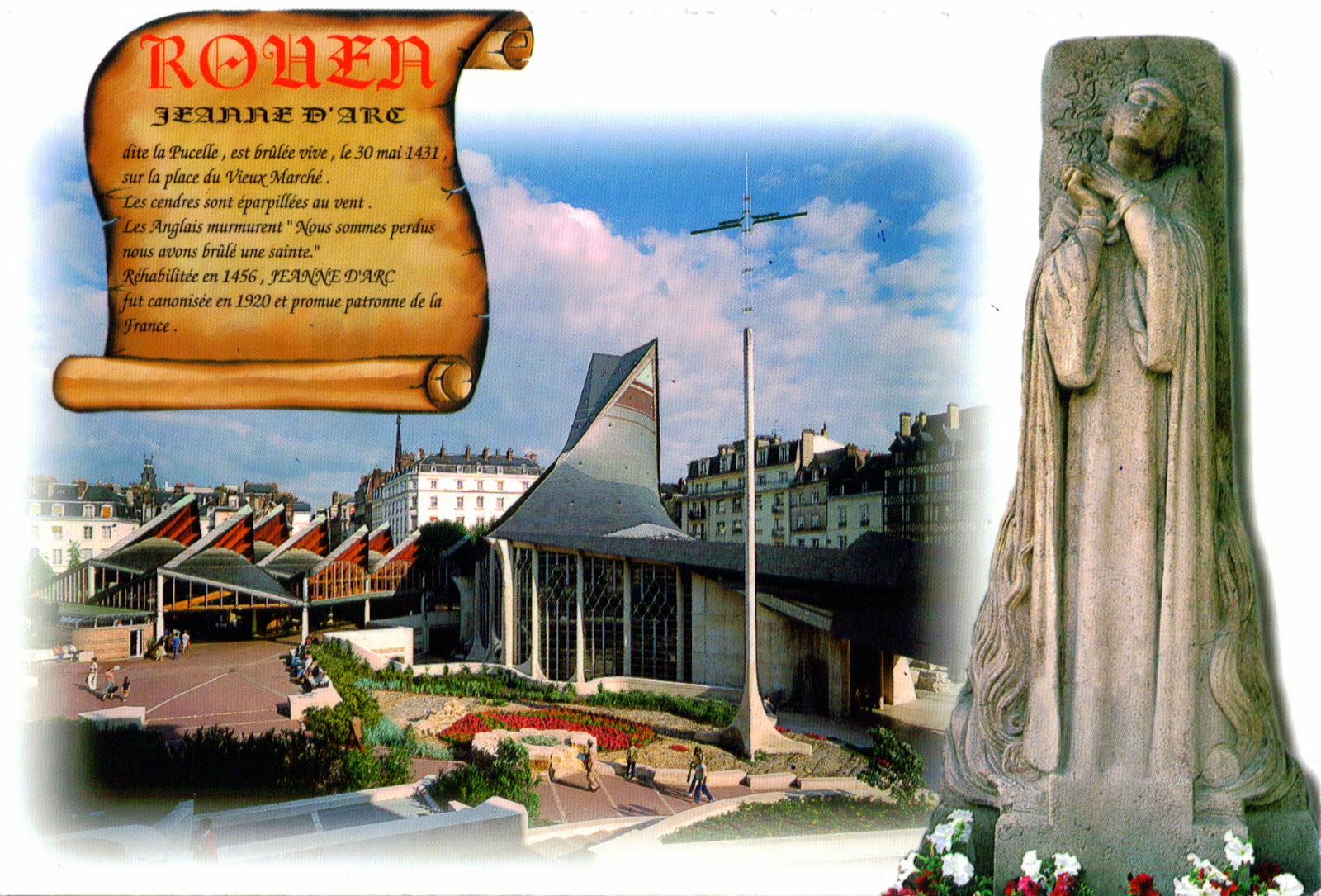
1200 FRANCE (Upper Normandy) - The Church and the Statue of Saint Joan of Arc in Rouen

$
0
0

Historic capital city of Normandy, one of the largest and most prosperous cities of medieval Europe, and one of the capitals of the Anglo-Norman dynasties, which ruled both England and large parts of modern France from the 11th to the 15th centuries, Rouen has also an unfortunate fame, because there was burned at the stake Joan of Arc, The Maid of Orléans, one of the iconic figures of France and a Roman Catholic saint. Born to a peasant family at Domrémy (in north-east France), Joan said she received divine visions instructing her to support Charles VII and recover France from English domination late in the Hundred Years' War. The uncrowned King Charles VII sent Joan to the siege of Orléans as part of a relief mission. She gained prominence after the siege was lifted in only nine days. Several additional swift victories led to Charles VII's coronation at Reims. On 23 May 1430, she was captured by the English-Burgundian faction, being later handed over to the English, and then put on trial, declared guilty, and burned at the stake on 30 May 1431, dying at about 19 years of age.

Read more »

1201 UNITED STATES (Virginia) - Assateague Lighthouse

$
0
0

Located on the southern end of Assateague Island (a 60 km long barrier island located off the eastern coast of Delmarva Peninsula) off the coast of the VirginiaEastern Shore, within the Chincoteague National Wildlife Refuge, Assateague Lighthouse is owned by the U.S. Fish and Wildlife Service and operated by the U.S. Coast Guard and is still used as an active aid in navigation. Conical in shape and painted in alternating bands of red and white, it has a base of over 9m and a height of  43m. A cast iron stairway reaches the existing electric revolving light which can be seen for 19 nautical miles. Was constructed in 1867 to replace a shorter lighthouse built in 1833.

Read more »
Viewing all 2426 articles
Browse latest View live