Quantcast
Channel: WORLD, COME TO MY HOME!
Viewing all 2426 articles
Browse latest View live

1499 ITALY (Sicily) - A Sicilian cart

$
0
0

The Sicilian cart (or carretto siciliano in Italian and carrettu sicilianu in Sicilian) is an ornate, colorful style of horse or donkey-drawn cart native to the island of Sicily. Horses were mostly used in the city and flat plains, while donkeys or mules were more often used in rough terrain for hauling heavy loads. The cart has two wheels and is primarily handmade out of wood with iron metal components. There are two types of carts: Carretto del Lavoro (cart for work), used for hauling miscellaneous, and Carretto de Gara, used for festive occasions. They were introduced to the island by the ancient Greeks, and reached the height of their popularity in the 1920s. The Museo del Carretto Siciliano, in Terrasini, in the province of Palermo, is a museum dedicated to the carts.

Read more »

1500 CONGO-KINSHASA - Virunga National Park (UNESCO WHS)

$
0
0

Located in the centre of the Albertine Rift, of the Great Rift Valley, the Virunga National Park (formerly named Albert National Park) stretches from the Virunga Mountains in the South, to the Rwenzori Mountains in the North, in the eastern Democratic Republic of the Congo, bordering Volcanoes National Park in Rwanda and Rwenzori Mountains National Park and Queen Elizabeth National Park in Uganda. It comprises an outstanding diversity of habitats, ranging from swamps and steppes to the snowfields of Rwenzori at an altitude of over 5,000 m, and from lava plains to the savannahs on the slopes of volcanoes. The wide diversity of habitats produces exceptional biodiversity, notably endemic species and rare and globally threatened species. Mountain gorillas are found in the park, some 20,000 hippopotamuses live in the rivers and birds from Siberia spend the winter there.

Read more »

1501 NEPAL - Sunrise over Mount Machhapuchhre, in the Annapurna Sanctuary

$
0
0

The Mount Machhapuchhre (literally "Fish Tail" in English) is located at the end of a long spur ridge, coming south out of the main backbone of the Annapurna Himal, that forms the eastern boundary of the Annapurna Sanctuary. The Sanctuary is a favorite trekking destination, and the site of the base camps for the South Face of Annapurna and for numerous smaller objectives. The peak (6,993m) is about 25 km north of Pokhara, the main town of the region. It is revered by the local population as particularly sacred to the god Shiva, and hence off limits to climbing. The only attempt was in 1957 by a British team, which stopped at 150m of the summit, because had promised not to set foot on it.

Read more »

1502 SAINT KITTS AND NEVIS - Rush hour!

$
0
0

Located in the eastern Caribbean Sea, in the Leeward Islands, Saint Kitts and Nevis is the smallest sovereign state in the Americas, in both area and population. The islands were discovered through a Spanish expedition under Columbus in 1493, and was home to the first British and French colonies in the Caribbean, being titled "The Mother Colony of the West Indies." They are of volcanic origin, with large central peaks covered in tropical rainforest; the steeper slopes leading to these peaks are mostly uninhabited. The majority of the population on both islands (consisting primarily of descendants of western Africans) lives closer to the sea where the terrain flattens out. Agriculture is the principal economic activity, although tourism is of increasing importance.

Read more »

0922, 0923, 1503 POLAND (Subcarpathia) - Tarnobrzeg

$
0
0
0922 - Tarnobrzeg - Square Bartosz Glowacki
The Dominican Church and Convent of Assumption of Mary


Posted on 29.12.2013, 28.03.2015
Founded in 1593, during the golden age of Poland, in the Sandomierz Basin, on the east bank of the river Vistula, to become the residence of the Tarnowski family, Tarnobrzeg remained a small town until the post-WWII period, when it became center of an industrial area, based on rich sulfur deposits. In 1772 it was incorporated in the Austrian Empire and remained in the province of Galicia until November 1918, when was declared the short-lived Republic of Tarnobrzeg. In 1919, the town became part of Lwow Voivodeship of the Second Polish Republic. Between 1975 and 1998 was the capital of Tarnobrzeg Voivodeship, since 1999 is situated in the Subcarpathian Voivodeship, and directly borders the town of Sandomierz.

0923 - Tarnobrzeg - Square Bartosz Glowacki
Statue of Bartosz Glowacki

The heart of the town is the Square Bartosz Glowacki. Until the 19th century the all buildings were made of wood, but in 1888 a fire destroyed almost the entire city, the houses being rebuilt with bricks. The Dominican Church and Convent of Assumption of Mary was founded in 1677. A year later the holy icon of Our Lady of Dzików was transferred from Dzików Castle to the monastery and since then the church became the Sanctuary of Our Lady of Dzików. Destroyed in 1703, was rebuilt in 1706, in Baroque style. Sometimes it's considered as the Our Lady of Tarnobrzeg or Queen of Sulfur Fields. In the north-eastern of the square is a statue of Bartosz Glowacki by Wladyslaw Korpal, erected on the initiative of the residents in 1904. In this way, the peasant became national hero in anti-Russian and anti-Prussian Kościuszko Uprising in 1794, has reached a sort of symbol of Tarnobrzeg, although in reality there is nothing to do with him.

1503 - Tarnobrzeg - Dzików Castle
 

Dzików Castle, or Tarnowski Family Castle in Dzików is a 15th-century (or perhaps a 14th-century) castle with the park complex and gardens. It was the site of Dzików Confederation of 5 November 1734, organized in order to reinstate Stanisław I Leszczyński as king of Poland after the death of August II the Strong. Over the years, the Tarnowski family acquired an impressive art collection housed in the Castle, which were, unfortunately, sold, seized, removed or lost in the 20th century. From 2007, the palace was under renovation, and in 2011, the ollections of the Historical Museum of the City of Tarnobrzeg was moved to the castle.

Read more »

1504 INDONESIA (Sumatra) - An omo sebua in Bawomataluo

$
0
0

Nias is a rugged island, the largest of the 131 chain parallel to the Sumatran coast. The native ethnic group which lives on the island bear the same name. The Nias people are a community that still actively living within the norms and practices of the indigenous culture. Their customary law is generally referred to as fondrakö, which regulates all aspects of life from birth to death. The caste system is also recognized in their society, whereby the highest level out of the 12 levels in the Nias caste system is Balugu. Niassan society is highly stratified and chiefs, particularly in the south of island, had access to a wealth of material resources and human labor. It was with this wealth that the early 20th century saw the chiefs of the isolated island build themselves the grand omo sebua.

Read more »

1505 UNITED STATES (Alaska) - Arctic Mariner returning to Dutch Harbor

$
0
0

The Bering Sea, located between Alaska, Bering Strait, Russia's Far East, Kamchatka Peninsula, Alaska Peninsula and the Aleutian Islands, is world renowned for its enormously productive and profitable fisheries. On the U.S. side, commercial fisheries catch approximately $1 billion worth of seafood annually. A top fishing port is Dutch Harbor, located on Amaknak Island in Unalaska. For 22 consecutive years, it is the number one fishing port in United States for seafood landings, and its docks are busy much of the year, landing more than 515 million pounds of fish and shellfish in 2010. Arctic Mariner is a fishing vessel by 390 tons, built in 1980 on Nichols Bros Boat Builders from Freeland (Washington). Its home port is Seattle.

Read more »

1506 UNITED KINGDOM (England) - Barnsley Road, Stairfoot, circa 1900-1910

$
0
0
Barnsley Road, Stairfoot, circa 1900-1910

Now, Ardsley is a small village approximately 5km east from Barnsley and forms part of the Metropolitan Borough of Barnsley of South Yorkshire. The earliest written evidence for the existence of Ardsley dates from the 12th century, and its name derives from the Saxon word leah (meaning a forest clearing or meadow), together with the personal name Eored, therefore means "Eored’s forest clearing". Stairfoot is also an urban village in the Metropolitan Borough of Barnsley, surrounded by Kendray and Ardsley, which gets its name from a house called "the Stares Foot" which stood very close to the Black Bull. The original "stair" was probably a stepped causeway built for the packhorses on the salt route from Cheshire to Doncaster (now the main Doncaster Road, which lead into Barnsley town centre).

Read more »

1507 BURUNDI - Batwa people and their pottery

$
0
0

The Great Lakes Twa (Batwa in English) are a pygmy people, generally considered to be the oldest population of the Great Lakes region, though currently they live as a Bantu caste. Current populations (approximately 80,000 people) are found in Rwanda, Burundi, Uganda, and the eastern portion of the DR Congo. Traditionally, they have been a semi-nomadic hunter-gatherers of the mountain forests living in association with agricultural villages. When the Hutu arrived in the region, they subjugated the people that they called Abatwa, the ancestors of the Batwa. Around the 15th century, the Tutsi arrived and dominated both the Hutu and the Twa, creating a three-caste society with the Tutsi governing, the Hutu the bulk of the population, and the Twa at the bottom of the social scale.

Read more »

1508 BAHAMAS - Paradise Island Bridge

$
0
0

Formerly known as Hog Island, Paradise Island is located just off the shore of the city of Nassau, which is itself located on the northern edge of the island of New Providence. With about 2 miles wide and 5 miles long, It is best known for the sprawling resort Atlantis with its extensive water park rides, pools, beach, restaurants, walk-in aquarium and casinos. Its first development took place when millionaire Axel Wenner-Gren, one of the richest man at that time, bought the island in 1935. He dredged the old pond, dug channels to link the lake with the harbor and the open sea and refurbished the already commodious estate, inspired by the imaginary land in James Hilton's novel Lost Horizon. He named his refuge Shangri-La. The island is connected to the New Providence by two bridges that cross Nassau Harbour, first built in 1966, and the second in the late 1990s.

Read more »

1509 LITHUANIA (Klaipėda) - Ventė Cape Lighthouse

$
0
0

Ventė Cape is a headland in Nemunas Delta, known as a rest place for many birds during their migrations, particularly the autumn migration. The Cape, being in the former Memel Territory, was part of Germany until 1919, and was marked as one of the most dangerous places in different old maps. It is the main reason why an 11m-high lighthouse (one of the seven that exist in Lithuania) stands in the horn. The first wooden lighthouse in Ventė Cape was built in 1837, surrounded by water on three sides. The present red brick lighthouse was built in 1852, at 30m from the Curonian Lagoon, and its signal is seen from 3.5km. In order to protect the lighthouse, the horn of Ventė Cape was paved with stones in 1860. Water measuring station was built next to the lighthouse in 1880.

Read more »

0061, 1510 MALAYSIA (Sarawak) - Iban people

$
0
0

0061 - Ibans performing ngajat dance in a longhouse

Posted on 05.12.2011, 04.04.2015
The population of Borneo (the third largest island in the world, divided between IndonesiaMalaysia, and  Brunei), totaling 20 million, mainly consists of Dayak ethnic groups, Malay, Banjar, Orang Ulu, Chinese and Kadazan-Dusun. Dayak is actually a generic term that designate six native clusters subdivided into approximately 450 sub-clusters, each with its own dialect, customs, laws, territory and culture. One of the most important branch of the Dayak are the Ibans, or Sea Dayak, located in Sarawak, Brunei, a small portion in Sabah and West Kalimantan. In the past, the Dayak practiced the headhunting, and the Ibans were pioneers of this custom, but after conversion to Christianity the practice was banned and disappeared, only to resurface in WWII (against the Japanese) and in the late 90s, when Dayak attacked Madurese emigrants.

1501 - An Iban with his grandson

The Ibans live in longhouses (rumah panjai), a massive communal structures usually located along a terraced river bank (there are over 4,500 longhouses only in Sarawak). They might reach up to 12m in height and to hundreds of metres in lenght, at times bringing more than 100 families under one roof, and affording safety from attacks during times of warfare. A traditional longhouse is built of axe-hewn timber, tied with creeper fibre, roofed with leaf thatch. Inside, the families live in separate apartments arranged along a central corridor (ruai), which serves as a communal area. Lack of class distinction favors this way of life. Or maybe vice versa? Anyway, in nowadays many have abandoned this system in favour of individual houses.

Read more »

1511 NIGER - The Djado Plateau and its forts (UNESCO WHS - Tentative List)

$
0
0

The Djado Plateau lies in northeastern Niger, and it is known for its cave art (often of large mammals long since absent from the area), but is now largely uninhabited, with abandoned towns and forts still standing and visible. The forts are the first architectural elements made from stone and clay in this area, found also in Tichitt Walata in Mauritania, and symbolize the first civilizations organized on the period of desiccation of the Sahara. There is no certainty about who were the founders of the settlement, but at some point the Kanouri people occupied it, they being the last inhabitants of the oasis. The reasons for the abandon aren't clear; it could be frequent raids in the area or the sickly amount of mosquitoes. Today the area is dominated by the Toubou people, who take care of the palm gardens.

Read more »

1512 GERMANY (Thuringia) - Bach House in Eisenach

$
0
0

The Bach House in Eisenach is a museum dedicated to the famous composer of the Baroque period Johann Sebastian Bach, who was born in the city in 1685, and spent the first 10 years of his life there. The core of the building complex is a half-timbered house, ca. 550 years old, which was identified as Bach's birth house in the middle of the 19th century. In 1905, the Neue Bachgesellschaft acquired the building, and in 1907 it was opened as the first Bach museum. Even though in 1928 it was discovered that Bach wasn't born in that house, the museum remained as a Bach memorial site, and even extended to the other surrounding properties. From 2005 to 2007, the buildings to the west of the Bach House were replaced by a new museum building, the historical building again underwent restoration, and the exhibition was completely modernized.

Read more »

1513 JAMAICA - Ackee and Breadfruit

$
0
0

The ackee (Blighia sapida) is native to tropical West Africa, was imported to Jamaica (probably on a slave ship) before 1778, and since then it has become a major feature of various Caribbean cuisines. The scientific name honours CaptainWilliam Bligh who took the fruit from Jamaica to the Royal Botanic Gardens in Kew, England in 1793. The fruit is pear-shaped. When it ripens, it turns from green to a bright red to yellow-orange, and splits open to reveal three large, shiny black seeds, each partly surrounded by soft, creamy or spongy, white to yellow flesh - the aril. Ackee is the national fruit of Jamaica, and ackee and saltfish is the national dish. Ackee pods should be allowed to ripen on the tree before picking. Prior to cooking, the ackee arils are cleaned and washed. The arils are then boiled for approximately 5 minutes and the water discarded. The dried seeds, fruit, bark, and leaves are used medicinally.

Read more »

1444, 1514 SRI LANKA - Golden Temple of Dambulla (UNESCO WHS)

$
0
0
1444 Golden Temple of Dambulla - Maha Raja Vihara

Posted on 07.02.2015, 06.04.2015
Situated in the central part of the country, Golden Temple of Dambulla, also known as Dambulla Cave Temple, is the largest and best-preserved cave temple complex in Sri Lanka. There are more than 80 documented caves in the surrounding area, and the rock towers 160m over the surrounding plains. This temple complex dates back to the 1st century BC, but prehistoric Sri Lankans would have lived in these cave complexes before the arrival of Buddhism in Sri Lanka as there are burial sites about 2700 years old in this area. The larger site incorporates a set of individual units reflecting all phases of site development from the megalithic period to the present day, including a monastic chapter house, bo-tree temple, dagoba and the earliest known village in Sri Lanka. Those are located within a site of considerable natural beauty and power.

1514 Golden Temple of Dambulla - The Golden Buddha statue

The complex has five caves under a vast overhanging rock, carved with a drip line to keep the interiors dry. In 1938 the architecture was embellished with arched colonnades and gabled entrances. Inside the caves, the ceilings are painted with intricate patterns of religious images following the contours of the rock. This complex dates from the 3rd and 2nd centuries BC, when it was already established as one of the largest and most important monasteries, and is still functional. King Valagambahu is traditionally thought to have converted the caves into a temple in the 1st century BC. Exiled from Anuradhapura, he sought refuge here from South Indian usurpers for 15 years. After reclaiming his capital, the King built a temple in thankful worship. Many other kings added to it later and by the 11th century, the caves had become a major religious centre and still are.

Read more »

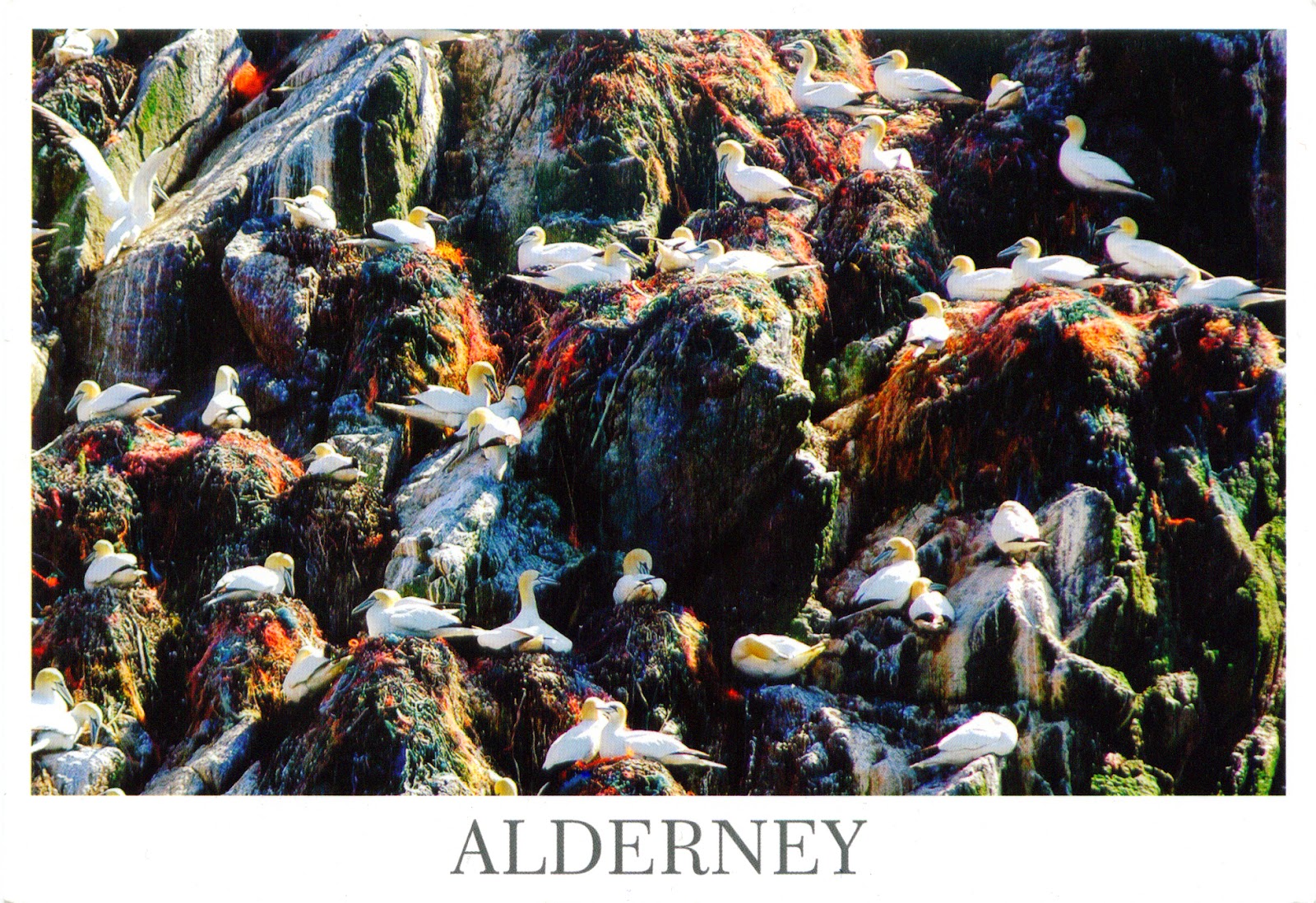
1264, 1515 GUERNSEY (Alderney) - Braye Harbour and Gannet Rock

$
0
0
1264 ALDERNEY - Moorings alongside the breakwater
at Braye Harbour

Posted on 02.10.2014, 07.04.2015
Alderney, part of the Bailiwick of Guernsey, is the most northerly of the Channel Islands, located at around 16km to the west of La Hague (Normandy, France), and 32km to the north-east of Guernsey. It is 4.8km long and 2.4km wide, and has about 1,900 inhabitants, formally known as Ridunians (from the Latin Riduna), but traditionally nicknamed vaques (after the cows), or else lapins (because of the many rabbits seen in the island). It shares a history with the other Channel Islands, becoming an island in the Neolithic period as the waters of the Channel rose. Its many dolmens have suffered through the large-scale military constructions of the 19th century and also by the Germans during the WWII occupation. Moreover, Germans fortified the island abandoned by inhabitants, as part of Hitler's Atlantic Wall, and built four concentration camps.

1515 ALDERNEY - Springtime on Gannet Rock

Braye Harbour is the main harbour on the north side of the island. It is an artificial harbour created by building a pier or jetty. The harbour faces out onto the Swinge, which is part of the English Channel. The breakwater at the Braye Harbour was built between 1847 and 1864. Originally, two arms were planned as a protection to the harbour, but only the western arm was completed, with a length of 1,471 m. Within a year 540 m was abandoned to the sea following heavy gales. The massive stone breakwater is generally used as a walk way to enjoy the scenic beauty of the bay, its harbour and the sea. Braye Harbour has a slipway but it doesn't have a marina and there are no alongside pontoon systems to berth to.

Read more »

1516 SAINT LUCIA - Pitons Management Area (UNESCO WHS)

$
0
0
 

The Pitons are two mountainous volcanic spires rising side by side from the sea (770 m and 743 m high respectively), linked by the Piton Mitan ridge, and located near the town of Soufrière, on the southwestern coast of Saint Lucia. The volcanic complex includes a geothermal field with sulphurous fumeroles and hot springs. The Marine Management Area is a coastal strip 11km long and about 1km wide. It comprises a steeply sloping continental shelf with fringing and patch reefs, boulders and sandy plains. The coral reefs, which cover almost 60% of the marine area, are healthy and diverse. The dominant terrestrial vegetation is tropical moist forest grading to subtropical wet forest, with small areas of dry forest and wet elfin woodland on the summits.

Read more »

1517 BARBADOS - The beach where landed the first settlers

$
0
0

The first English ship arrived in Barbados, where is now the Holetown, on the sheltered west coast of the island, on May 14th 1625, after what appears to have been a fortuitous accident. Captain John Powell and the crew of Olive Blossom were sailing from Brazil to England and went off course, due to a navigational error. Powell found the island to be uninhabited and claimed it in the name of King James I of England. On his return to England informed his employer, Sir William Courteen (a Dutch-born English merchant trader), what it happened. Immediately Courteen sent Powell back to occupy Barbados and establish a settlement. However, Powell never made it, as en route to Barbados he captured a Spanish ship and needed to return it to England.

Read more »

1518 LATVIA - Girls in traditional costumes in the Old Town of Riga

$
0
0

The Latvian national costume is basically the traditional festive outfit of ordinary folks as worn in the 19th century, approximately up to the 1870s. However, is not just a certain type of festive garb: it is an expression of a nation’s sense of beauty, ability to form an ornament and put together colors, as well as knowledge of the craft. It embodies centuries-old traditions of making, adorning, and wearing the costume, and is a composite of a variety of festive outfits. There are many local varieties that are combined based on the five cultural-historical or ethnographic areas of Latvia: Vidzeme, Latgale, Augšzeme, Zemgale, and Kurzeme. It is possible that at the basis of the older, barely determinable distinguishing marks of the traditional costume are the outfits of Baltic tribes and Livs living in what is now the territory of Latvia.

Read more »
Viewing all 2426 articles
Browse latest View live